


WELCOME TO THE CHURCH TO STEELE ELECTRONIC ENVIRONMENTAL REVIEW DOCUMENT (eERD)
Executive Summary
Delmarva Power & Light Company (Delmarva Power) proposes to rebuild the existing 138 kilovolt (kV) transmission line (Circuit 13701) from the Church Substation in Queen Anne's County to the Steele Substation in Caroline County, Maryland (herein Church-Steele or Project). The line is located entirely within the existing 300-foot rights-of-way (ROWs). The existing 25.5-mile ROW contains three transmission circuits, the 138 kV Church-Steele Circuit 13701 on wooden H-frame structures, and two 230 kV circuits (23001 and 23009), which are supported on lattice tower structures. Delmarva Power has submitted an application (Application) to the Maryland Public Service Commission (PSC) for a Certificate of Public Convenience and Necessity (CPCN) pursuant to Section 7-207 of the Public Utility Companies Article of the Annotated Code of Maryland and Title 20, Subtitle 79 of the Code of Maryland Regulations (COMAR) requesting authorization to rebuild the Church-Steele Project.
Delmarva Power conducted a comprehensive review of readily available local, state, and federal public data, including Maryland Geographic Information System (GIS) resource data layers, and regulatory agency databases. As part of the Project data review process, Delmarva Power requested relevant information from appropriate agencies to facilitate the analysis of possible resource-related effects from the Project. Table 1.3-1 provides a summary of agency contacts for the Project. Additionally, Delmarva Power conducted Project specific field studies for resources within the Project ROW. These studies were used, along with public data, to establish the existing conditions and conduct the effects analysis of the Project on natural resources (Appendices F-I).
Delmarva Power implements avoidance and minimization measures (A&M) during all phases of Project development (Table 1.1-1 in Appendix E). The Delmarva Power Project team (e.g., Environmental, Engineering, Construction Management) has developed Project specific environmental avoidance and minimization commitments to minimize environmental effects of the Project to the extent practicable (Section 3.0). Figure ES-1 below is a graphical representation of the typical cross sections showing the existing and proposed configuration for the Project ROW based upon the best available engineering data at the time of the Environmental Review Document (ERD) submittal.
Project Effects
To address COMAR Section 20.79.04 requirements, Delmarva Power evaluated the potential effects of the Project on resources in the existing Church-Steele ROW. This multi-step evaluation, which Delmarva Power characterizes as an "environmental effects assessment" examines potential Project effects to individual resources. Delmarva Power's environmental effects assessment, which includes an initial effects assessment, an avoidance and minimization evaluation, and a final effects determination is described in detail in Section 1.4. Details of the Project effect determination process are included in Section 2.0. Project effect determinations are broken down into the following categories: No effect, Minor effects, Moderate effects, and Significant effects. The analysis: reviews natural resources, cultural resources, socioeconomics, and land use. The analysis evaluates the significance the proposed access, real property constraints, and proposed construction activities may have on a particular regulated or protected resource. It identifies opportunities for resource avoidance and minimization and includes a detailed Project effects analysis, which incorporates relevant and appropriate best management practices (BMPs). These measures are identified by Delmarva Power as environmental commitments to minimize overall environmental effects and conform to the applicable environmental standards.
Through this process, Delmarva Power has demonstrated that the Church-Steele Project will have only Minor effects to resources. Below is a comprehensive list of the Project's potential effect on resources. A detailed summary of the proposed Project effects can be found in Table 2.1-3.
Resources with No Project Effects
- Geology
- Socioeconomic
- Potential Contaminated Sites
- Land Use
- Cultural Resources
Resources with Minor Project Effects
- Soils
- Vegetation
- Wildlife
- Air
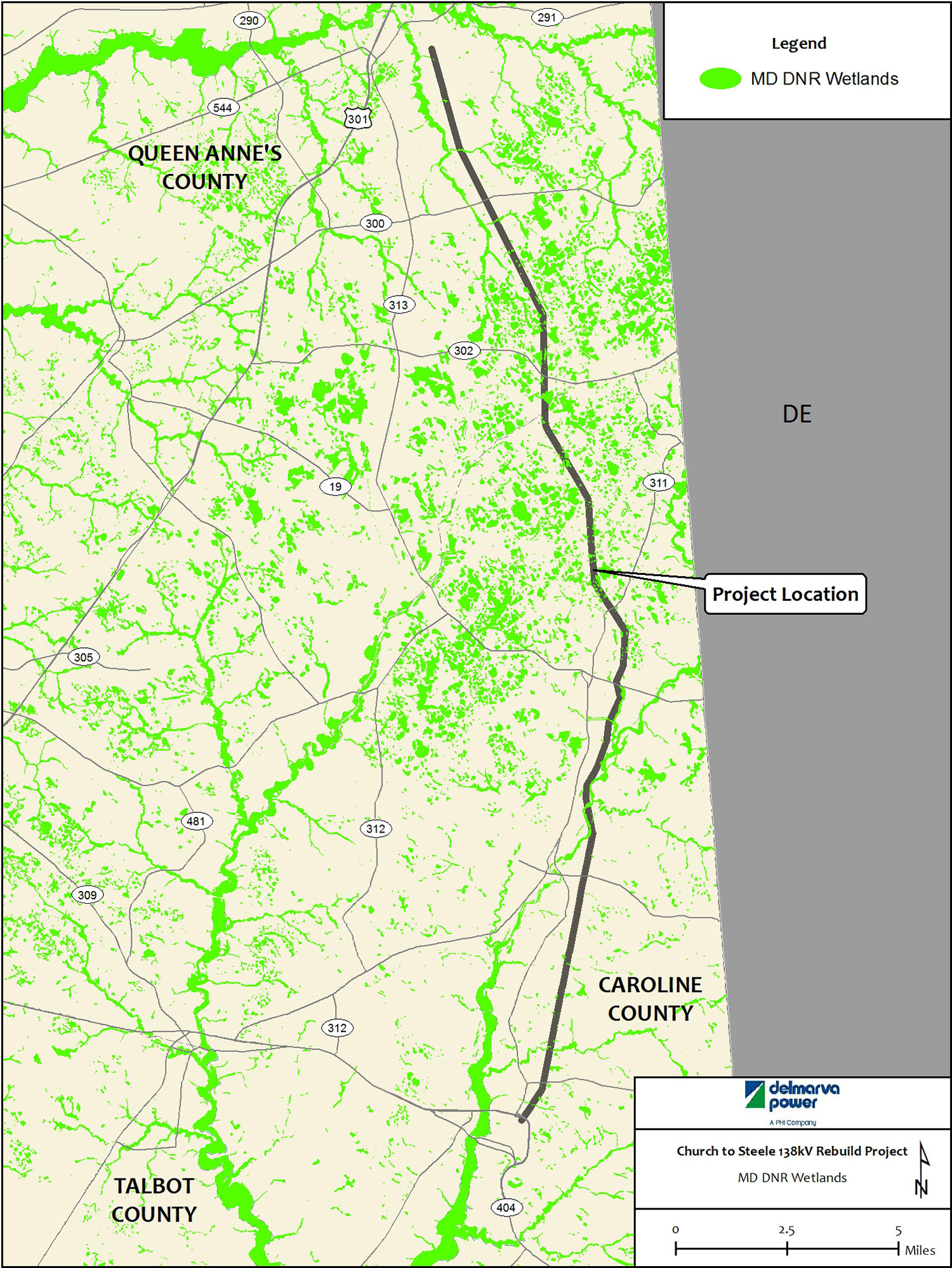
- Non-Tidal Wetlands
- Water Resources
- Fisheries
- Noise
- Rare, Threatened, and Endangered (RTE) Species and Habitat
Delmarva Power will minimize overall environmental effects by utilizing the existing transmission ROW, applying relevant and appropriate BMPs during construction activities to protect the environment, committing to specific ongoing ROW maintenance practices during operation of the line, and complying with applicable environmental policies and regulations.
Acronym List
A&M - Avoidance and Minimization
AADT - Average Annual Daily Traffic
Act - Smart and Sustainable Growth Act of 2009
AOLIC - Avian Power Line Interaction Committee
BMP(s) - Best Management Practice(s)
BWI - Baltimore/Washington International Airport
CAC - Critical Area Commission
CBI - combined biotic index
CERCLIS - Comprehensive Environmental Response, Compensation, and Liability Information System
Church-Steele - Church Substation to Steele Substation 138 kV transmission (Circuit 13701) Rebuild Project (or Project)
COMAR - Code of Maryland Regulations
CPCN - Certificate of Public Convenience and Necessity
CREP - Conservation Reserve Enhancement Program
CZMA - Coastal Zone Management Act
CZMP - Coastal Zone Management Program
Delmarva Power - Delmarva Power & Light Company
DFS - Delmarva Fox Squirrel
EDR - Environmental Data Resources, Inc.
eERD - Electronic ERD
EFH - Essential fish habitats
EMS - Emergency Medical Services
ERD - Environmental Review Document
°F - degrees Fahrenheit
FAA - Federal Aviation Administration
FCA - Maryland Forest Conservation Act
FCP - Forest Conservation Plan
FEMA - Federal Emergency Management Agency
FERC - Federal Energy Regulatory Commission
FIDS - Forest Interior Dwelling Species
FINDS - Facility Index System
FIRM - Flood Insurance Rate Maps
FSD - Forest Stand Delineation
ft² - square feet
GIA - Green Infrastructure Assessment
GIS - Geographic Information System
GPS - global positioning system
HIST UST - Historical Underground Storage Tank
HUC - Hydrologic Unit Code
IBI - Index of Biotic Integrity
IEEE - Institute of Electrical and Electronics Engineers
IPRU - Integrated Policy and Review Unit
IVM - Integrated Vegetation Management
kV - kilovolts
LCD - Local Climatic Data
LEAD - Maryland Lead Registry
MALPF - Maryland Agricultural Land Preservation Foundation
MBSS - Maryland Biological Stream Survey
MD DNR - Maryland Department of Natural Resources
MDE - Maryland Department of the Environment
MD-OCP - MDE's Oil Control Program
MDOT - Maryland Department of Transportation
MDP - Maryland Department of Planning
MFRI - Maryland Fire and Rescue Institute
mg/l - milligrams per liter
MGS - Maryland Geological Survey
MHAA - Maryland Heritage Areas Authority
MHT - Maryland Historical Trust
mph - miles per hour
MRRP - Midshore Regional Recycling Program
MTN - Martin State Airport
NAAQS - National Ambient Air Quality Standards
NERC - North American Electric Reliability Corporations
NHD - National Hydrography Dataset
NMFS - National Marine Fisheries Service
NOAA - National Oceanic and Atmospheric Administration
NOI - Notice of Intent
NPDES - National Pollutant Discharge Elimination System
NRCS - Natural Resource Conservation Service
NRHP - National Register of Historic Places
NTIS - National Technical Information Service
NWI - National Wetlands Inventory
OPGW - optical ground wire
PEM - Palustrine Emergent
PFA - Priority Funding Area
PFO - Palustrine Forested
PPA - Priority Preservation Area
Project - Church Substation to Steele Substation 138 kV transmission Circuit 13701 Rebuild Project (or Church-Steele)
PSC - Maryland Public Service Commission
PSS - Palustrine Scrub-Shrub
PUB - Palustrine Unconsolidated Bottom
QAEC - Queen Anne's Emergency Center
RCRA UST - Resource Conservation and Recovery Act Underground Storage Tank
RCRA-SQG - Resource Conservation and Recovery Act Small Quantity Generator
RGA-HWS - Recovered Government Archive State Hazardous Waste Sites
ROW(s) - Right(s)-of-Way
RTE - Rare, Threatened, and Endangered
SHA - State Highway Administration
SHWS - State Hazardous Waste Sites
SSPRA - Sensitive Species Project Review Areas
SSURGO - NRCS's soil survey geographic
TEA - Targeted Ecological Areas
TMDL - Total Maximum Daily Loads
TSS - total suspended solids
USACE - US Army Corps of Engineers
USDA - US Department of Agriculture
USEPA - US Environmental Protection Agency
USFWS - US Fish and Wildlife Service
USGS - United States Geological Survey
WHS - Wildlife and Heritage Service
WSSC - Wetlands of Special State Concern
yd³ - cubic yards
Table 2.1-3 Existing Environmental Conditions & Project Effects
RESOURCE |
EXISTING CONDITIONS |
Avoidance and Minimization MEASURES |
COMMENTS |
|---|---|---|---|
Resources with No Effects |
|||
GEOLOGY |
Coastal Plain |
NONE - No Unique geological features are within the ROW. |
Removal and installation of utility structures will not adversely affect geologic features or mineral mining sites. |
POTENTIAL CONTAMINATED SITES |
None identified within the ROW |
If encountered during construction contaminated material will be handled in accordance with Delmarva Power procedures and all regulatory requirements. |
Based upon the proximity/location of the sites to the ROW it is not anticipated that project could be affected by contaminated sites. |
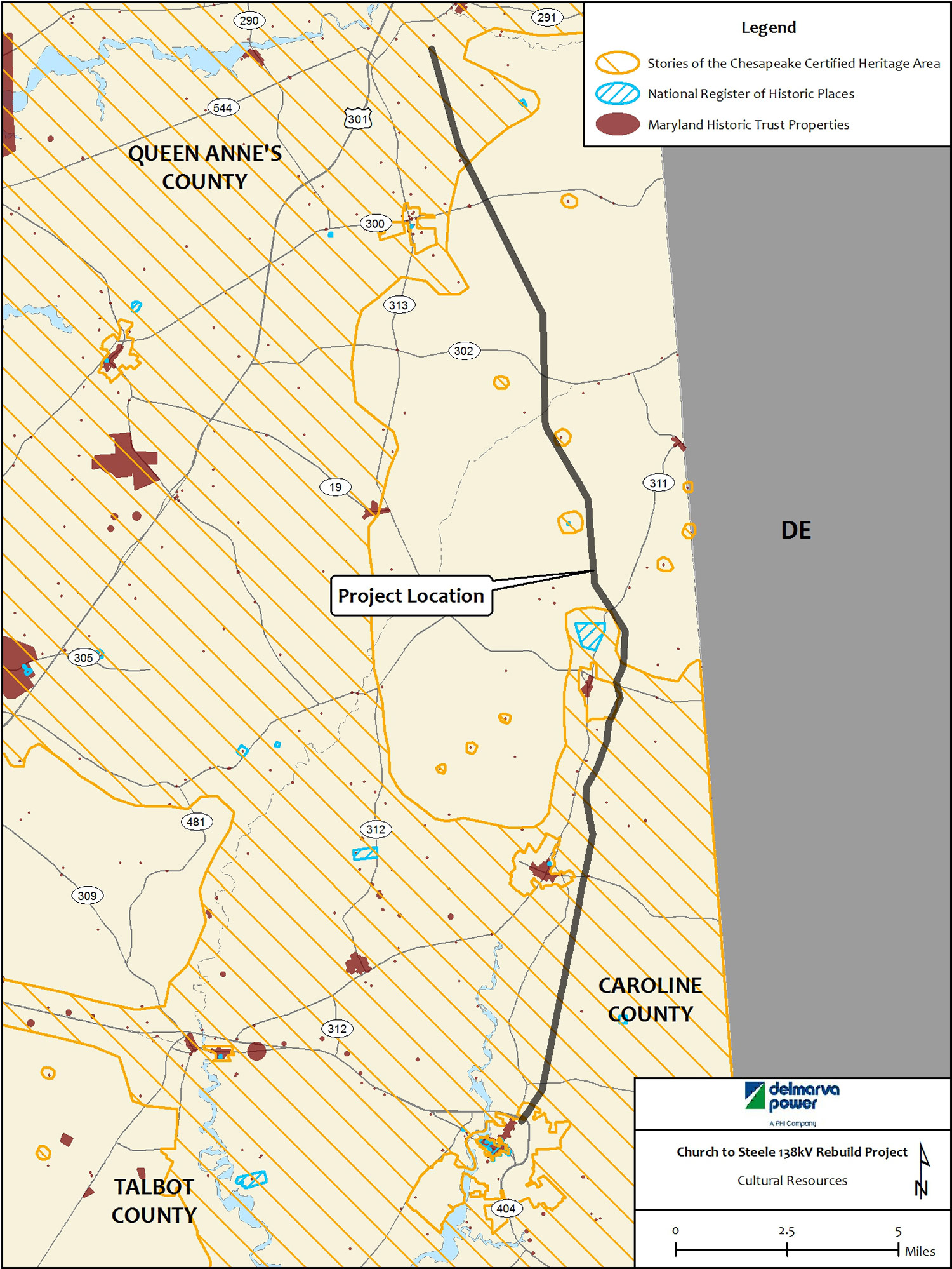
CULTURAL RESOURCES |
19 historic sites located near the ROW. |
No Historic Properties or archeological sites are located within or immediately adjacent to the Project ROW. |
Structure replacement, equipment mobilization, and conductor installation will result in no adverse effects to cultural resources. |
SOCIO-ECONOMIC |
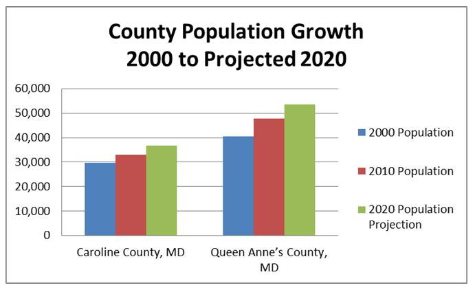
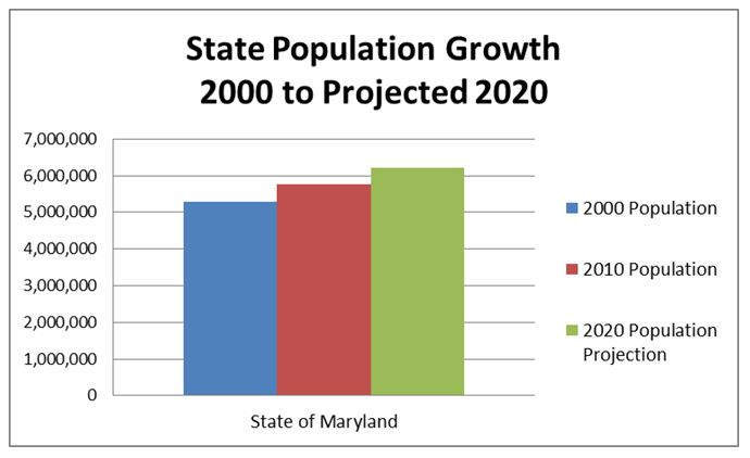
Population, education, healthcare, county facilities, schools, emergency services, public services, waste management, roadways. |
NONE - The Project will have no short-term and long-term effect on population, education, healthcare, county facilities and services or schools. |
No new development within the Project ROW. |
LAND USE |
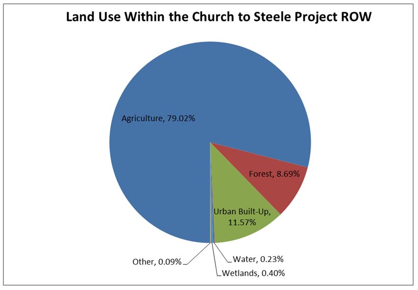
79% of Project ROW is agriculture with the majority being cropland. |
Reseeding of disturbed areas. The replacement of existing structures and the associated construction activities will not affect agricultural land preservation efforts. |
Replacement of structures and construction activities will not result in effects to agricultural land preservation efforts. |
Resources with Minor Effects |
|||
SOILS |
52 soil units |
BMPs - erosion and sediment controls, reseeding in areas with exposed soil or areas with steep slopes. Use of existing access, farm roads and public roads to reach the Project ROW |
Minor, short-term effects to soils within the Project ROW may occur during structure installation with soil erosion and soil compression from construction equipment. Temporary matting to support construction equipment and minimize soil disturbance would be used in areas where compression and ruts may occur. All soil-disturbing activities will comply with erosion and sediment control regulatory requirements |
WATER RESOURCES |
Watersheds - (Upper Chester River, Tuckahoe Creek and Upper Choptank River) |
Apply BMPs during construction activities near streams to control erosion and sedimentation. |
Minor effect on water resources within watersheds; Temporary effects to streams resulting from construction activities, primarily access. Temporary effects to floodplains resulting from construction activities and access, some new fill resulting from installation of new structures. Minor effect on surficial aquifers during installation of structures. |
VEGETATION |
Actively maintained transmission ROW. |
Coordinate with local land owners to avoid crop damage. |
Planned vegetation management activities will take place in the existing ROW. |
WILDLIFE |
No FIDS, Colonial Nesting bird habitat, waterfowl staging areas, bald eagle nesting sites are located within the ROW. |
Implement BMPs during construction to minimize habitat disturbance. |
Temporary effects from construction vehicle access and structure installation. |
FISHERIES |
Species of concern: |
Implement BMPs during construction to minimize stream disturbance and erosion, and sedimentation from construction activities. |
Effects to Yellow Perch and Swamp Darters habitat are not anticipated. |
AIR |
Queen Anne’s and Caroline Counties are designated attainment areas for the USEPA’s NAAQS criteria pollutants. |
Implement BMPs during construction to minimize dust from construction activities. |
The criteria pollutants in the area of the Project ROW are below the levels established by the NAAQS. BMPs will minimize and suspended particles from dust. |
NOISE |
No noise receptors within Project ROW. |
Coordinate with local residents and officials and adjust work hours, if needed. |
Construction activities will generate moderate noise, but the adjacent land uses are primarily agricultural fields. |
RTE SPECIES AND HABITAT |
Delmarva Bays (Vernal Pools) Habitat which includes Eastern tiger salamander, barking treefrog and numerous plant species. |
Implement BMPs during construction to minimize vegetation disturbance and known species habitat. |
Specific surveys are required by the state. Surveys will begin during the appropriate season. Through continued coordination with DNR, commitments will be made regarding avoidance and minimization. |
NON-TIDAL WETLANDS |
79 non-tidal wetlands |
Install temporary matting equipment access in wetlands and wetland buffers. |
The existing structures will be replaced with new structures and where possible wetlands will be avoided. Construction activities and access will use temporary matting and BMPs to minimize the effect on wetlands. |
1. Introduction
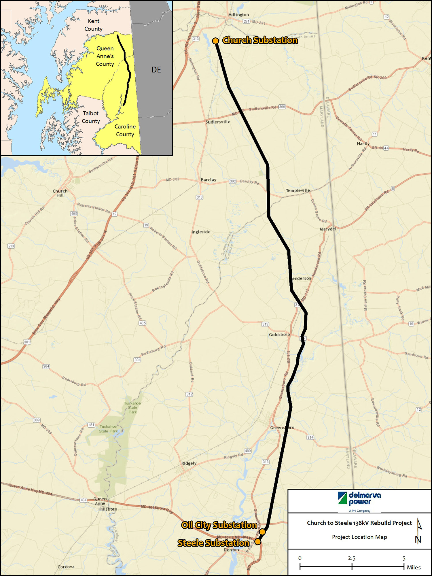
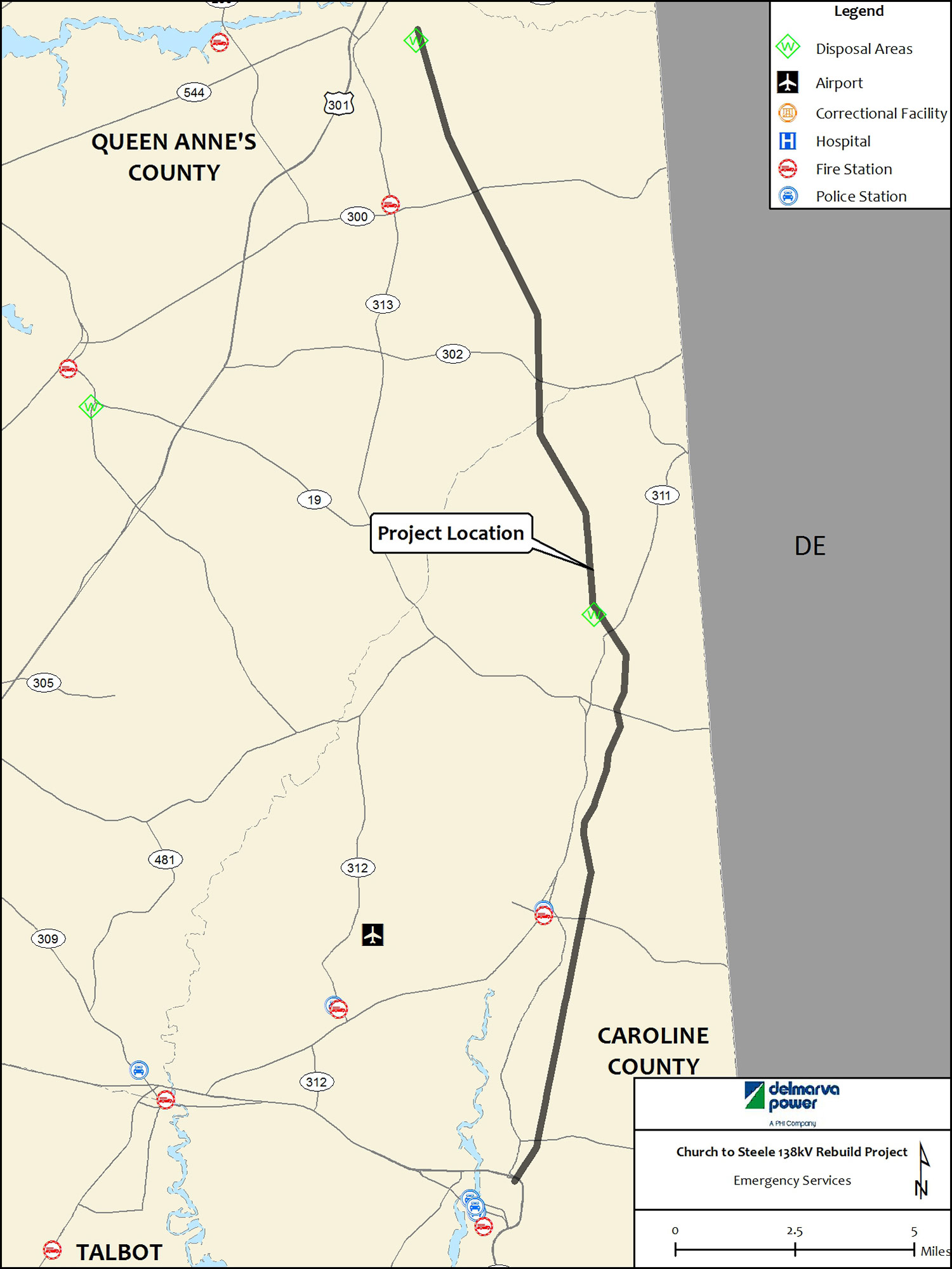
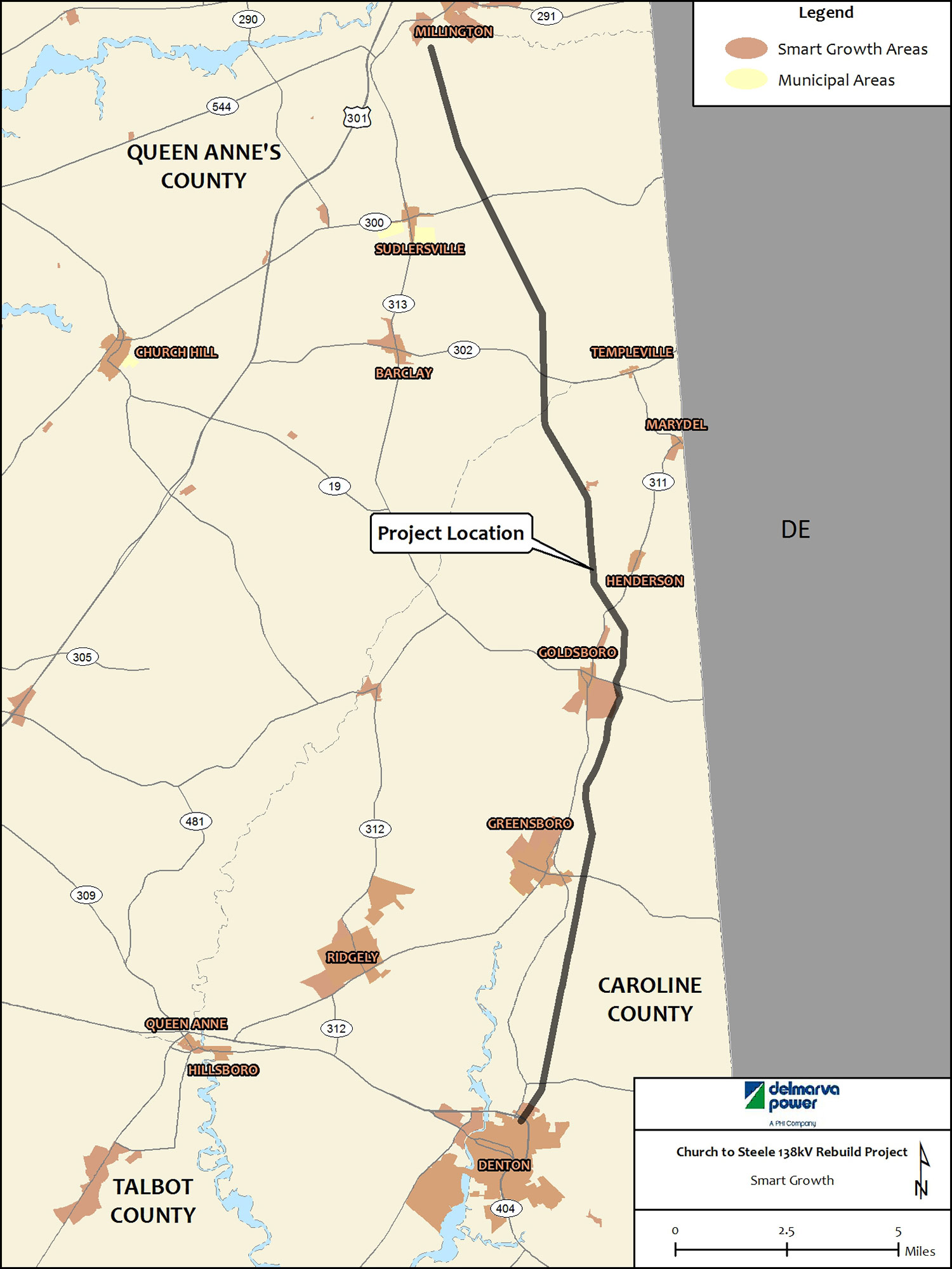
Pursuant to the provisions of Section 7-207 of the Public Utilities Article of the Annotated Code of Maryland and Sections 20.79.01 and 20.79.04 of the Code of Maryland Regulations (COMAR) requiring entities constructing overhead transmission lines greater than 69 kilovolts (kV) to obtain a Certificate of Public Convenience and Necessity (CPCN) from the Maryland Public Service Commission (PSC), Delmarva Power & Light Company (Delmarva Power) is submitting an application for a CPCN to rebuild the existing 25.5-mile 138 kV transmission line (Circuit 13701) between Delmarva Power's Church Substation in Queen Anne's County to Delmarva Power's Steele Substation in Caroline County, Maryland (Church-Steele line or Project) ( Figure 1.0-1). The proposed structures will be rebuilt entirely within the existing rights-of-way (ROWs). This Environmental Review Document (ERD) was prepared to provide the environmental information required by COMAR Section 20.79.04.04.
ERD Review
Delmarva Power has developed an electronic ERD (eERD) for the Project as a digital application and geographic information system (GIS)-based tool to assist in ERD review and facilitate the environmental review process. The eERD presents the narrative, summary tables, mapping, and figures in a user-friendly interactive web-based environment. The eERD enables reviewers to view and search documentation regarding existing conditions including natural resources, cultural resources, land use and socioeconomics, proposed access routes and construction methods, potential Project effects, and Delmarva Power's proposed environmental commitments to progressively conform to applicable environmental regulatory standards. The eERD provides reviewers with a simple functional interface, including links to dynamic maps with layers, summary tables, and visualization aids (e.g., video, photo simulation, and other graphic information). The eERD provides the reviewer with the capability to focus on various components of the ERD, as well as a Geographic Information System (GIS) mapping tool to view multiple layers of data with the intended effect of enhancing the presentation of the Project.
1.1 Project Description
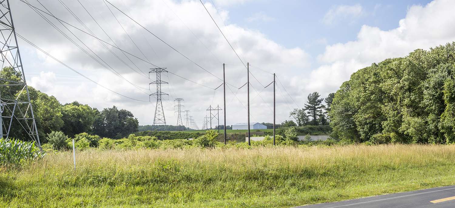
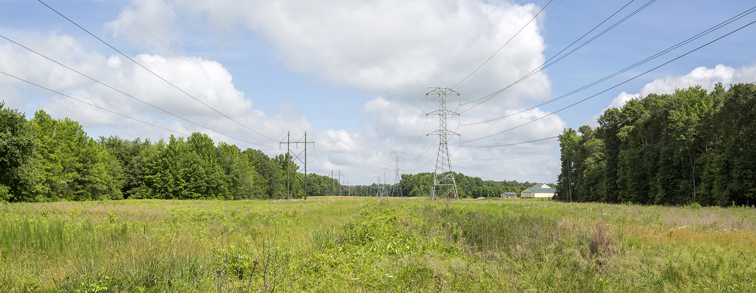
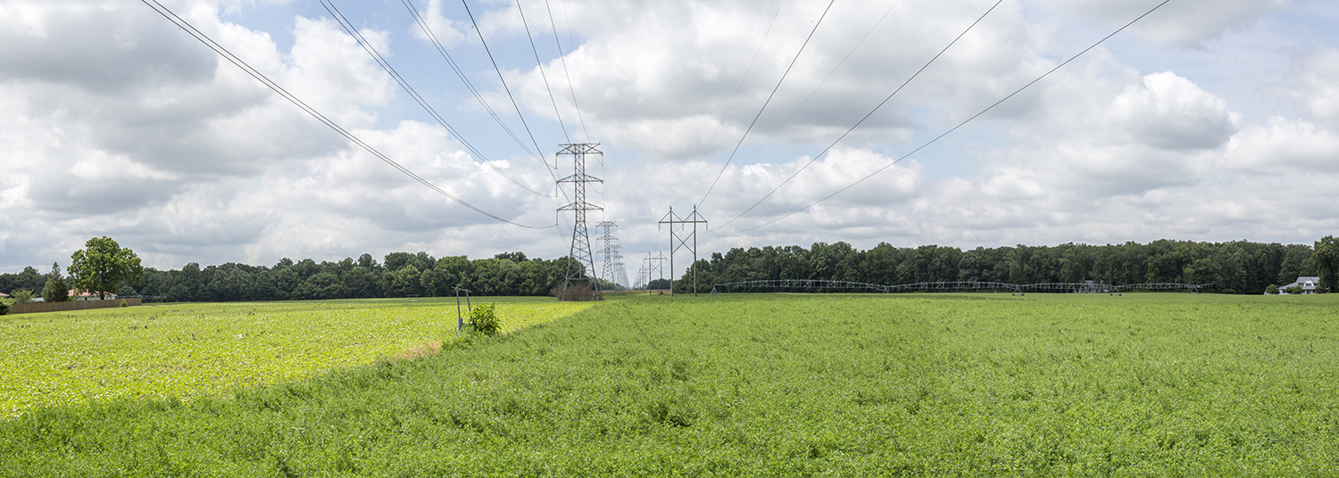
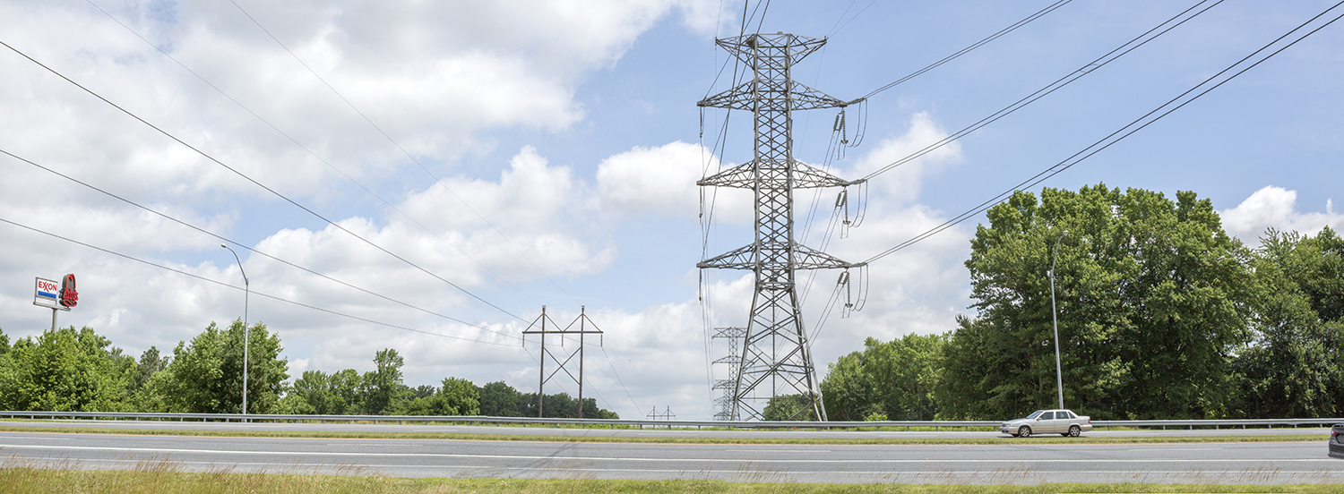
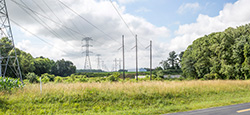
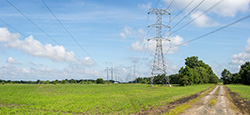
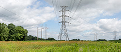
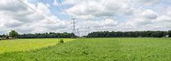
The Project involves replacing the existing 138 kV (Circuit 13701) H-frame wood structures and installing new overhead circuit and static wire on steel monopoles within the existing ROW. The transmission line (Circuit 13701) generally runs north to south from Millington, Maryland to Denton, Maryland ( Figure 1.0-1). The Project ROW is 25.5 miles long and 300 feet wide, with the exception of a 775-foot section outside the Church Substation where it is 150 feet wide. The ROW contains three transmission circuits: the 138 kV Church-Steele wood H-frame Circuit (Circuit 13701), and two 230 kV circuits (Circuits 23001 and 23009), which are supported on lattice towers. The Project will not require the acquisition of additional property or property rights.
Generally, the rebuilt line will be constructed 75 feet from the existing 230 kV circuits (Circuits 23001 and 23009). The entire ROW encompasses approximately 931 acres. Where feasible, structure locations have been adjusted to minimize impacts to resources as described in Appendix E. The typical ROW cross-section and proposed structure types are shown in Appendix E.
The information provided in this ERD is based upon the best available information at the time of the CPCN filing. The engineering details provided for the environmental analysis are sufficient to determine environmental effects of the Project. The environmental data has been supplemented with field assessment data, including wetland delineation (Appendix M); raptor nest surveys (Appendix N); cultural resource reviews (Appendix G); habitat assessments (Appendix O); targeted Rare, Threatened, and Endangered (RTE) species surveys (pending); and ongoing agency coordination and regulatory database review.
1.2 Project Schedule
The proposed construction start date for the Project is February 2016. The construction schedule and sequencing for the Project will be developed based on engineering, transmission system, and environmental constraints. The proposed in-service and completion date for the Project is May 2017 (Appendix E, Section 4.0).
1.3 CPCN Application Support
This ERD provides an analysis of the environmental impacts that construction and the long term maintenance of the Project may have on environmental resources and provides other COMAR-required information in support of the CPCN application. The ERD includes:
- A list of each local, state, or federal government agency having authority to approve or disapprove the construction or operation of the Project and contains a statement (Table 1.3-1) indicating the following [COMAR 20.79.01.04.E]:
- Whether the necessary approval from each agency has been obtained, with a copy of each approval or disapproval attached (Appendix B ).
- If necessary approval has not been obtained, the reason why.
- Whether any waiver or variance has been granted or requested, with a copy of each attached.
- Location and identification of access roads for construction or maintenance either existing or to be built (Appendix C) [COMAR 20.79.04.02.C].
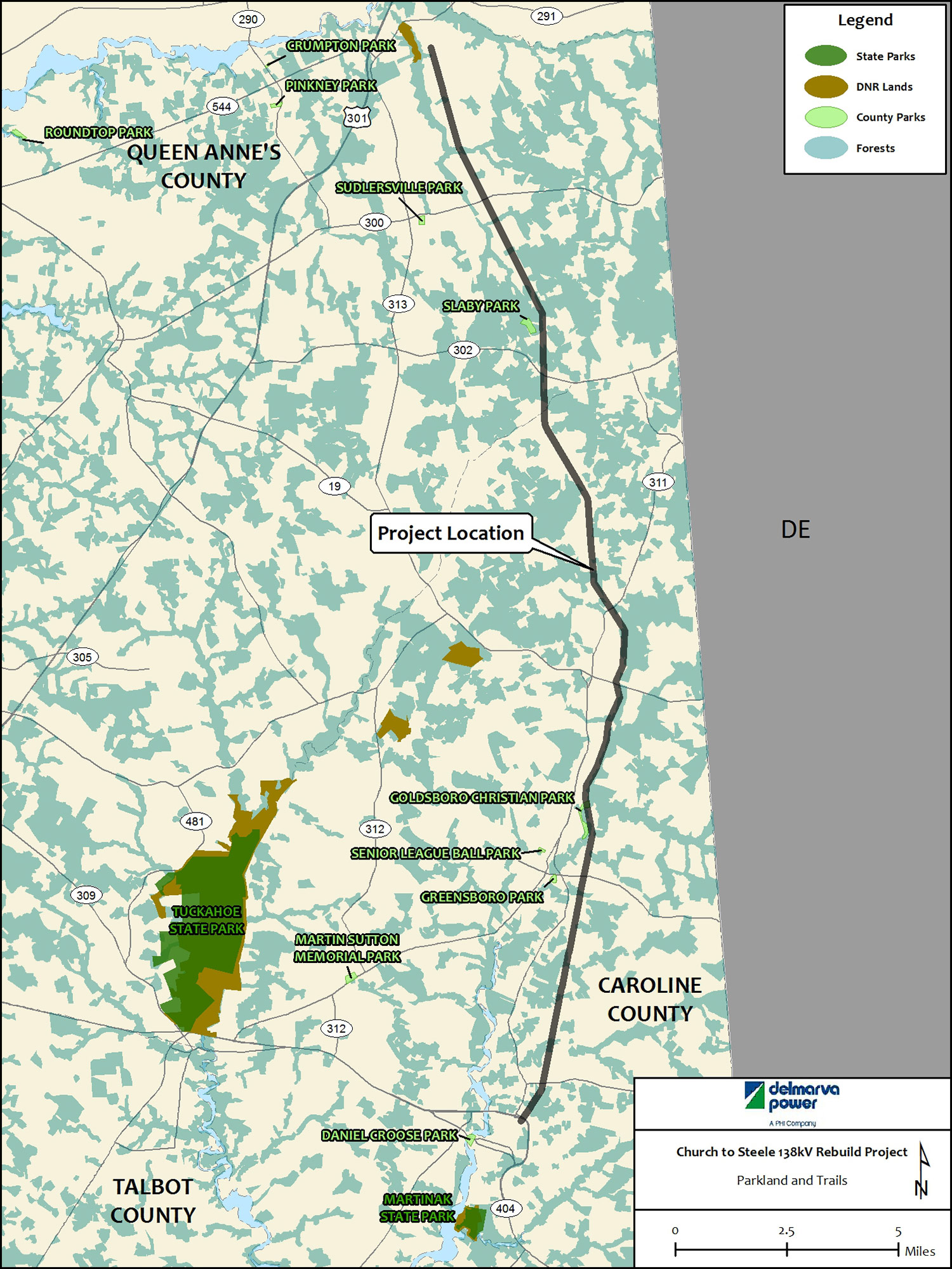
- Location and identification of the following sites from which the Project would be clearly visible [COMAR 20.79.04.02. D(1)-(7)]:
- Historical (Appendix G)
- Institutional land (Appendix H-I)
- Recreational area (Appendix H)
- Aesthetic (Appendix G-I)
- Archeological (Appendix G)
- Wildlife management area (Appendix F)
- Park or forest (Appendix F-I).
- Location and identification of all portions of the Project ROW requiring construction within the 100-year floodplain of any stream ( Appendix F and Appendix D, Figure D-2) [COMAR 20.79.04.02.E].
- Location and identification of any public airport one mile or less from the transmission line (Circuit 13701) (Appendix H and Appendix D, Figure D-6) [COMAR 20.79.04.02.F].
- Depiction on suitable topographic map (minimum scale: 1 inch = 2,000 feet) of Items 2 through 5 above (Appendix D, Figure D-1) [COMAR 20.79.04.02.G].
- Environmental information required for transmission circuits, including [COMAR 20.79.04.04 et. seq.]:
- A general description of the physical, biological, aesthetic, and cultural features, and conditions of the site and adjacent areas ( Section 2.0 and Appendix F-I).
- A summary of the environmental and socioeconomic effects of the construction and operation of the Project, including a description of the unavoidable impacts and recommended mitigation (Section 2.0 and Appendix F-I).
- A copy of all studies of the environmental impact of the Project prepared by the applicant (Appendix F-I).
- A statement of the ability to conform to the applicable environmental standards (Section 2.0).
1.3.1 Agency Consultation
Delmarva Power sent consultation letters to various agencies and stakeholders to assist in identifying environmental issues and applicable permitting requirements. Table 1.3-1 provides a summary of agency contacts for the Project. Agency comments received are addressed in the appropriate resource section in this ERD. Copies of the correspondence provided to the various agencies and the responses received are provided in Appendix B.
1.3.2 Permits, Approvals, and Regulatory Requirements
A list of the environmental permits and other regulatory approvals that may be required to construct and operate the Project can be found in Table 1.3-2. Based on the information provided in this ERD, the Project conforms to all applicable environmental standards.
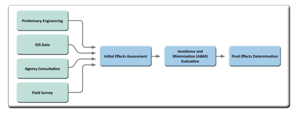
1.4 Environmental Effects Assessment
Delmarva Power conducted a detailed environmental effects assessment for the Project. An environmental effects assessment is the evaluation of the natural and cultural resources, land use, and socioeconomic for potential effects as a result of the Project. Delmarva Power completed an initial effects assessment of existing conditions to determine potential Project effects to resources. Next, avoidance and minimization for each resource was assessed. Following the initial effects assessment and avoidance and minimization analysis, relevant and appropriate best management practices (BMPs) and environmental commitments were determined and incorporated into the final design. A final determination was made regarding the effects of the Project on regulated/protected resources. The avoidance and minimization measures and BMPs are identified by Delmarva Power as environmental commitments to minimize impacts to resources and reduce the overall Project effect.
The results of the environmental effects assessment are summarized on Table 2.1-3. The following appendices contain the environmental resource technical reports, consultation letters, Project plans, and construction details.
- Appendix B: Consultation Letters
- Appendix C: Project Plans
- Appendix D: Resource Mapping
- Appendix E: Project Construction Details
- Appendix F: Natural Resource Technical Report
- Appendix G: Cultural Resources Technical Report
- Appendix H: Socioeconomic Technical Report
- Appendix I: Land Use Analysis
- Appendix J: Delmarva Power Best Management Practices
- Appendix K: Integrated Vegetation Management
- Appendix L: EDR Report
- Appendix M: Wetland Delineation Report
- Appendix N: Raptor Nest Report
- Appendix O: Habitat Assessment Report
Figure 1.4-1 depicts Delmarva Power's approach to the environmental effects assessment conducted for the Project. This includes Initial Effects Assessment, Avoidance and Minimization Evaluation, and Final Effects Determination. The Phases are described in further detail in the following sub-sections.
1.4.1 Initial Effects Assessment
The purpose of the Initial Effects Assessment is to use available GIS data, resource mapping, socioeconomic planning information, agency consultation, and field studies to evaluate existing conditions, and determine potential effects to resources within the Project area resulting from Project activities. The evaluation assumed the following construction activities:
- Installation of required erosion and sediment controls.
- Installation of construction access, including temporary matting in wetlands where necessary (access roads and around structures) and temporary bridges where necessary.
- Clearing brush and saplings around work areas.
- Excavation and subsequent installation of new structures including foundations, structures, cross-arms, and hardware.
- Wire pulling.
- Removal of old structures and complete restoration of work areas and access roads.
A description of proposed access associated BMPs, as well as the construction process anticipated for the Project (including construction elements, techniques, phasing, and schedule), is included in Appendix E.
1.4.2 Avoidance and Minimization Evaluation
Delmarva Power employs a wide variety of techniques, activities, BMPs, and work processes to avoid and/or minimize environmental impacts. These practices begin in the design and planning phases of a project and extend to construction and post-construction activities.
The A&M Evaluation includes the following steps:
- Conducting a structure-by-structure analysis to determine where impacts to resources can be avoided. Avoidance options are incorporated into the engineering and construction planning process.
- Identifying and selecting access to existing structures that maximizes the use of existing roads and minimizes new road access.
- Identifying structures that can be relocated from wetlands and wetland buffers away from wetlands and other sensitive resources.
- Conducting a feasibility analysis for use of temporary construction mats for wetland crossings and temporary bridges for stream crossings.
- Conducting avian risk review.
- Conducting field review for constructability.
The A&M Evaluation is discussed in detail in Appendix E, Section 1.0. Table 1.1-1 in Appendix E provides a listing of the typical programmatic environmental impact avoidance and mitigation measures employed by Delmarva Power for work along transmission line ROWs.
1.4.3 Final Effects Determination
After the Initial Effects Analysis and the A&M Evaluation were complete, the final Project effects to protected/regulated resources were determined for environmental, cultural, land use, and socioeconomics. The Project effects are summarized in Section 2.0 and Table 2.1-3.
1.4.4 Protection Measures
After reviewing the Project effects summary, Delmarva Power developed additional protection measures for the Project to minimize potential adverse impacts during construction. Section 3.0, describes the protection in detail.
2. Summary of Project Effects
2.1 Existing Conditions and Project Effects
This section provides a summary of the existing conditions within the Project ROW and the effects the Project may have on natural, socioeconomic, land use, and cultural resources.
Determination of the Magnitude or Significance of Impacts
The following hierarchy was used to determine the magnitude or significance of the impacts the Project may have on a particular regulated or protected resource.
- No Effect - The project has no or negligible impacts on regulated or protected resources.
- Minor Effect - The project is located within a previously disturbed area and has insignificant temporary or permanent impacts to regulated or protected resources.
- Moderate Effect - The project is located in a previously undisturbed area and has some temporary and permanent impacts to regulated or protected resources.
- Significant Effect - The project is located in a previously undisturbed area and has greater than moderate temporary or permanent impacts on regulated or protected resource areas.
Summary of Project Effects
A detailed summary of Project effects on existing conditions within the Project ROW, organized by magnitude of effect or impact, is summarized below. Maps of each of the resources evaluated have been provided in Appendix D: Table 2.1-3 which summarize the determination of Project effects.
2.1.1 No Effect
The Project will have no effect on the resources discussed below.
Geology
The Project ROW is located entirely within the coastal plain, consisting primarily of unconsolidated sediments including sands, silts, clays, and gravels that were deposited in marine, shallow water, or fluvial environments. There are no known unique geological features in the Project area. Although the Project ROW is located in an aquifer formation, the proposed removal of old structures and the installation of new structures will have a negligible effect on aquifer formations and groundwater or other geologic features within Queen Anne's and Caroline Counties. There are no mineral mining sites within the Project ROW (Appendix F, Section 1.0).
Potential Contaminated Sites
Based upon the EDR Radius report the entire length of the Project will be within a ROW currently used for electric transmission that does not contain any known contaminated sites. Multiple facilities with potential contamination concerns were identified within a one mile radius of the Project ROW. Due to the distance of these sites from the ROW, it is unlikely that contamination at any of the listed sites has impacted soils in the Project ROW. Therefore, the Project will have no impact on contaminated sites because there are none identified within the Project area ( Appendix F, Section 2.0).
Cultural Resources
Through consultation with the Maryland Historic Preservation Officer, it was determined that the proposed construction activities will result in no adverse impacts to cultural resources. On January 21, 2104, the MHT concurred that the Project will have no adverse effect on historic properties within the Project ROW (Appendix B). The proposed structures will range from an additional 30 to 60 feet in height compared to the existing structures. The Project ROW will have similar features of the existing utility circuit within the ROW that would not result in substantial changes in the view-shed of the ROW or negative visual effects in the Project area (Appendix G).
Socioeconomic
The Project will have no effect on population, education, healthcare, county facilities and services, or schools because the Project is within existing ROW and there will be no new ROW development. Impacts from the Project to public services, such as emergency services, law enforcement, and waste management will be negligible. Waste materials produced during construction will not strain existing management facilities and practices because of the minor quantities involved. The presence of construction vehicles and equipment may cause minor, short-term effects to traffic patterns on local roadways; however, the roadways are primarily located in rural areas that generally have lighter traffic loads. Construction mobilization will occur only during daylight hours and is not expected to require road closure. During construction, some local economic benefit may be achieved due to spending in the Project area and Project employment opportunities. Overall, impacts on socioeconomic factors will be negligible ( Appendix H).
Land Use
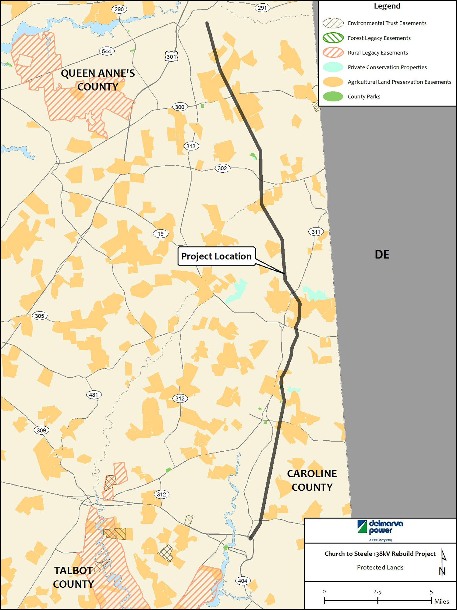
Land use in the vicinity of the Project is primarily agriculture. The Project area is located within the Coastal Plain Province and is characterized by relatively flat terrain. Approximately 79 percent of the land within the Project ROW is under agricultural use, including 77 percent as cropland. The Project ROW traverses Conservation Reserve Enhancement Program (CREP) land in Queen Anne's County and crosses multiple Maryland Agricultural Land Preservation Foundation (MALPF) easements in Queen Anne's and Caroline Counties. However, the replacement of existing structures and the associated construction activities will not affect agricultural land preservation efforts. Once construction is complete, conditions within the Project ROW are expected to be reestablished (Appendix I).
2.1.2 Minor Effects
The Project will have a minor effect on the resources discussed below.
Soils
Fifty-two soil units were identified and evaluated within or adjacent to the Project ROW. The 52 soil units generally have some or all of the following characteristics: highly erodible soils, compaction-prone soils, drought-prone soils, soils with low vegetation potential, and hydric soils. Soils within the Project ROW will be subject to disturbance during structure replacements, foundation installation and the removal of old structures. Site-specific disturbance and potential soil erosion and sedimentation will depend on existing grades and the presence or absence of vegetation. The erosion potential from Project construction is minor because of level terrain and minor excavation from structure placement. Potential effects on soils will be mitigated by MDE and County approved BMPs such as perimeter controls and stabilization measures. Where soil compaction is a site-specific concern, temporary construction mats will be installed to mitigate ruts and soil compression. All soil-disturbing activities will comply with sediment and erosion control regulatory requirements (Appendix F, Section 3.0).
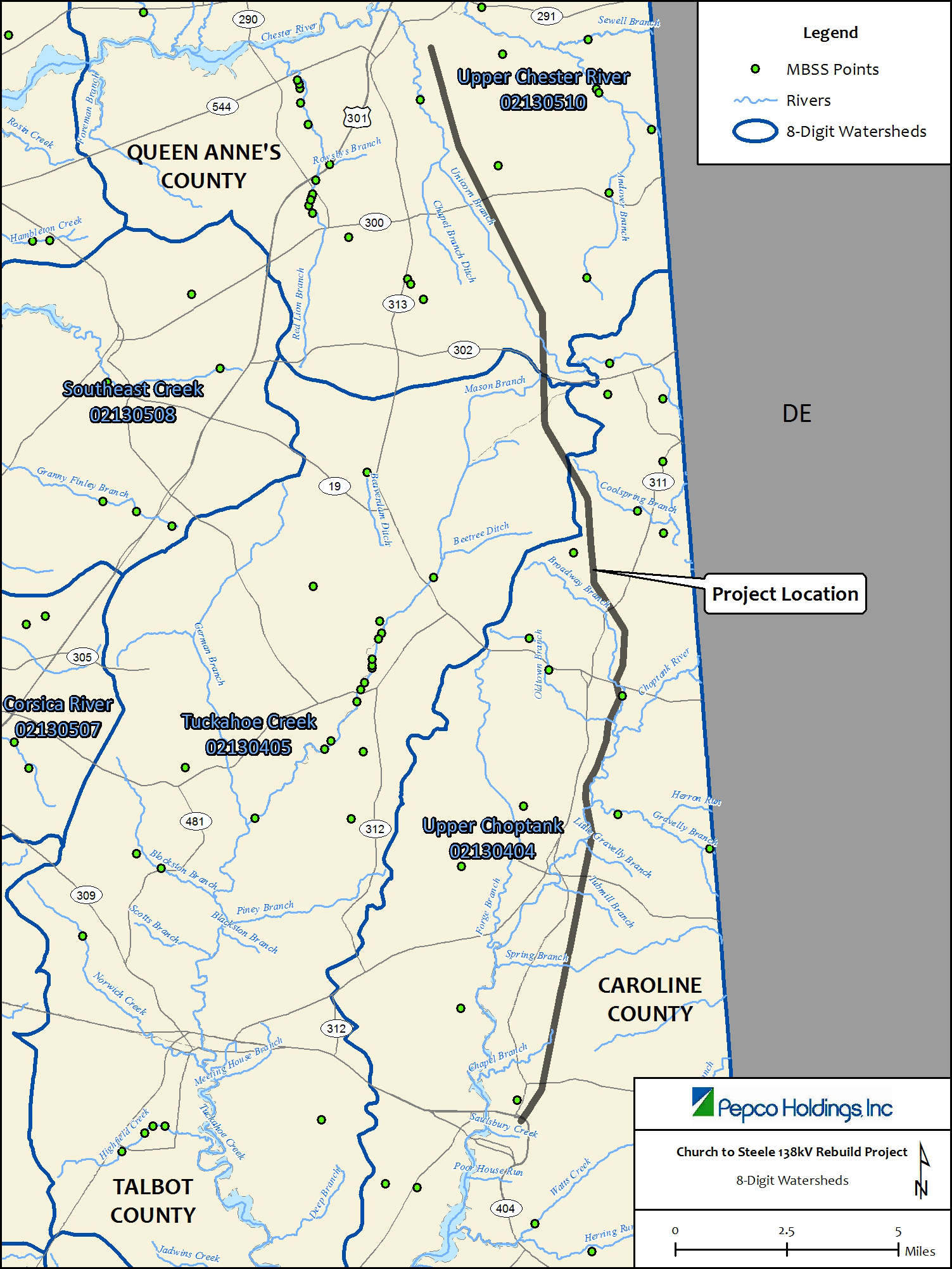
Water Resources - Surface Water, 100- Year Flood Plain, Groundwater
The Project ROW is located within three watersheds (Upper Chester River, Tuckahoe Creek, and Upper Choptank River) and crosses eight named streams and 42 unnamed tributaries (Appendix F, Section 4.0). The Project construction involves four temporary stream crossings. The limited Project scope (i.e., rebuilding structures within the existing ROW) and the implementation of appropriate BMPs, including avoiding stream crossings and using temporary bridges that span streams entirely, results in the Project having only minor effects on water resources within the Project ROW.
The Project ROW crosses approximately 27 acres of the 100-year floodplain. The southern portion of the ROW, south of Sandtown Road, crosses the 100-year floodplain of the Choptank River and its tributaries at seven different locations. Four structures are currently located in the 100-year floodplain and four structures will be rebuilt in the 100-year floodplain. These structures, although unavoidably located in the floodplain, will have a negligible effect on flood storage or flood flow because of the small volume of fill associated with the structure placement. During construction, Delmarva Power proposes to use appropriate BMPs for erosion and sedimentation control. Once the new replacement structures are placed, Delmarva Power proposes to remove the existing structures and restore the work area. As a result, the Project will have a negligible effect on the 100-year floodplain (Appendix F, Section 4.0).
The Project ROW is entirely within the Eastern Shore's surficial aquifer. The limited Project scope and implementation of appropriate BMPs, including proper dewatering methods during structure installation, result in the groundwater resources within the Project ROW being adequately protected ( Appendix F, Section 4.0).
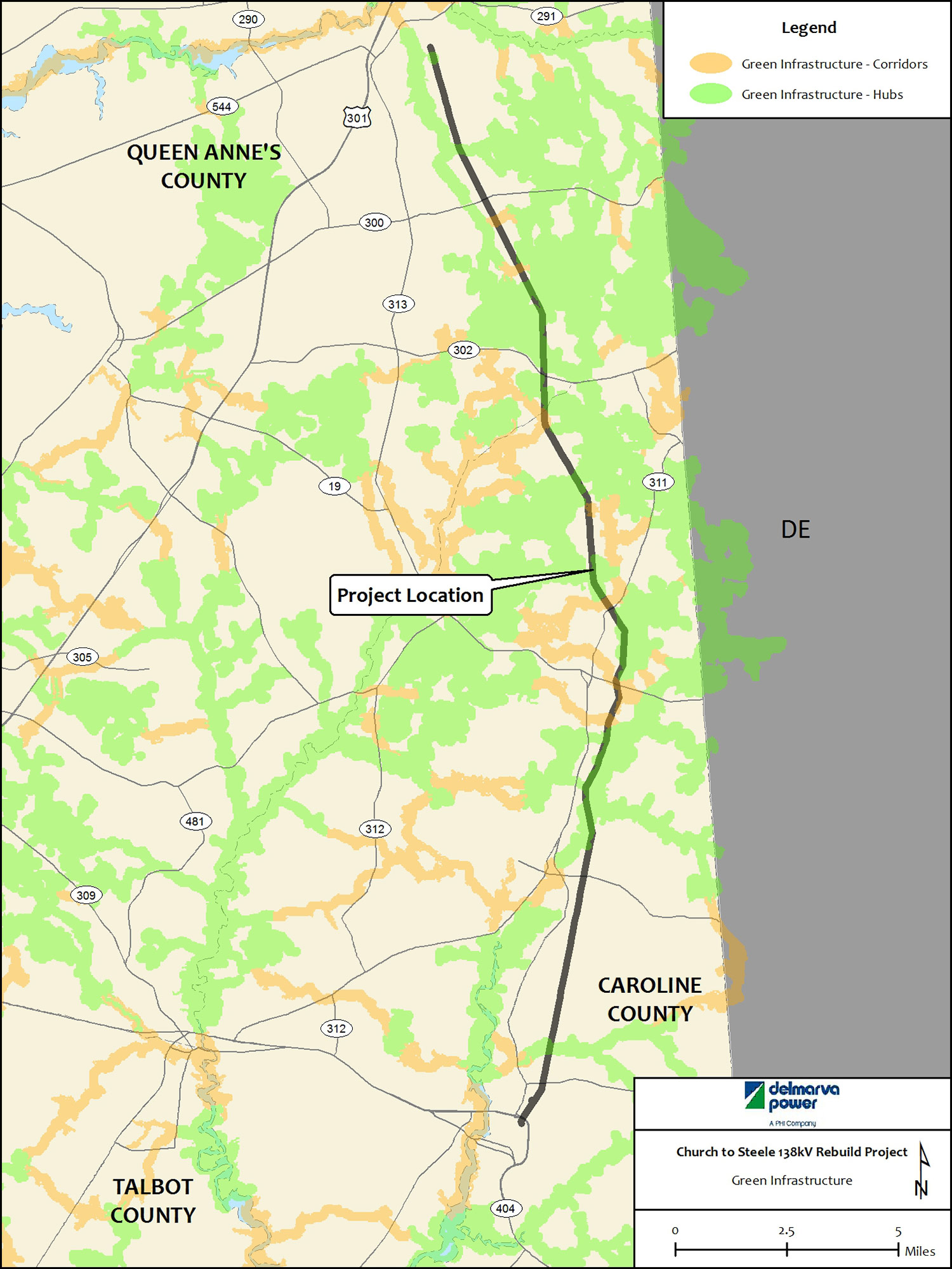
Vegetation - MD DNR Green Infrastructure Areas and Rural Legacy Lands
Queen Anne's and Caroline Counties are located within the Coastal Plain ecoregion. The land cover within and adjacent to the ROW consists primarily of agricultural lands (soybeans and corn), wetlands, and forests. The Project ROW is primarily active agriculture with non-agricultural areas dominated by herbaceous and shrub cover. Approximately nine percent of the area adjacent to the Project ROW consists of forested areas. Delmarva Power does not propose to expand the existing ROW. Planned vegetation management activities will take place in the existing ROW. Project construction activities will have a minor temporary effect from access and equipment staging areas and the installation of new structures on existing vegetation in the ROW that is not agricultural (Appendix F, Section 6.0).
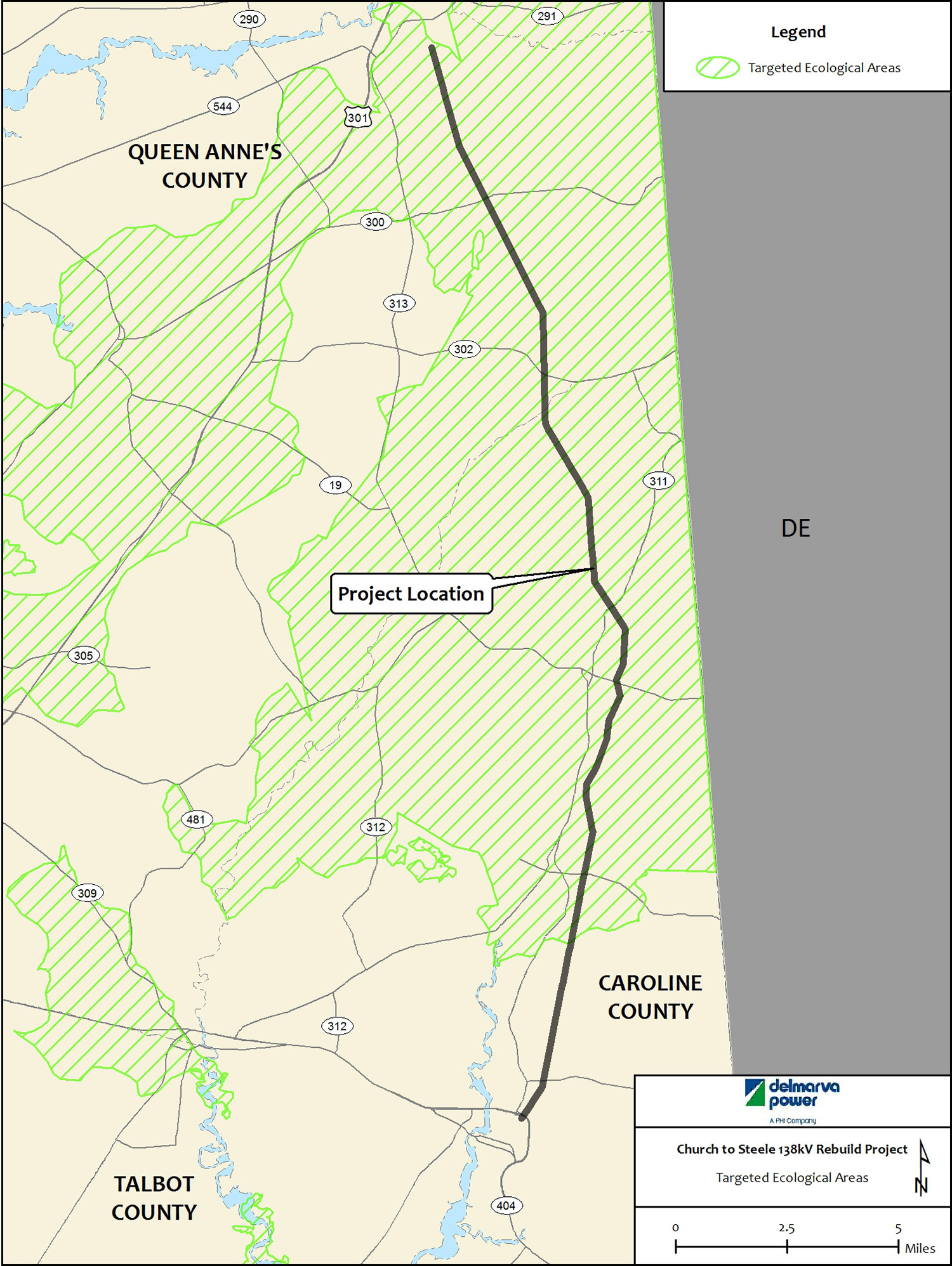
The Project ROW intersects several Green Infrastructure Hubs, Gaps, and Corridors. Approximately 34 percent of the Project ROW consists of habitat identified as Hubs; 27 percent consists of Gaps; and nine percent of ROW is within habitat identified as Corridors. Hubs are large, contiguous blocks of forests, wetlands, habitat areas, and other unique ecological communities and are at least 100 acres in size. Gaps are human-disturbed areas including developed, agricultural, mined, or cleared lands within the Green Infrastructure. Corridors are linear features such as stream valleys and mountain ridges that connect hubs, facilitating the movement of plant species and animals between hubs. The intent of the Maryland Green Infrastructure is to minimize fragmentation of Corridors and Hubs and where possible restore vegetation in the Gap areas (Appendix F, Section 6.0). The Project ROW is considered a Gap within the Green Infrastructure. However, the vegetated portions of the Project ROW provides potential habitat for grassland and "edge" species within the adjacent Green Infrastructure areas.
Planned vegetation management activities will take place in the existing ROW. Delmarva Power does not propose to expand the existing ROW. To minimize vegetation disturbance in the ROW that bisects designated MD DNR Green Infrastructure areas, Delmarva Power will (subject to appropriate landowner permission) restore and maintain the ROW such that the ROW wire zone supports a low growing plant community dominated by grasses, herbs, forbs, and small shrubs under 10 feet in height at maturity. This vegetation management strategy will conserve cover vegetation and encourage wildlife use in the ROW. The Project may result in temporary disturbance to vegetation from planned vegetation management activities and construction within the existing maintained ROW in MD DNR Green Infrastructure mapped areas that are not in active cultivated agricultural fields. In general, vegetation disturbance in Green Infrastructure areas will not result in fragmentation of Corridors or Hubs. Disturbance will be temporary and limited to access and equipment staging areas (Appendix F, Section 6.0).
The Project ROW also intersects Rural Legacy Area lands in Queen Anne's County and Caroline County. As previously stated Delmarva Power will conduct planned vegetation management activities in the existing ROW. However, Delmarva Power does not propose to expand the existing ROW. Therefore, it will not result in the fragmentation of Rural Legacy Areas or Green Infrastructure areas (Appendix F, Section 6.0).
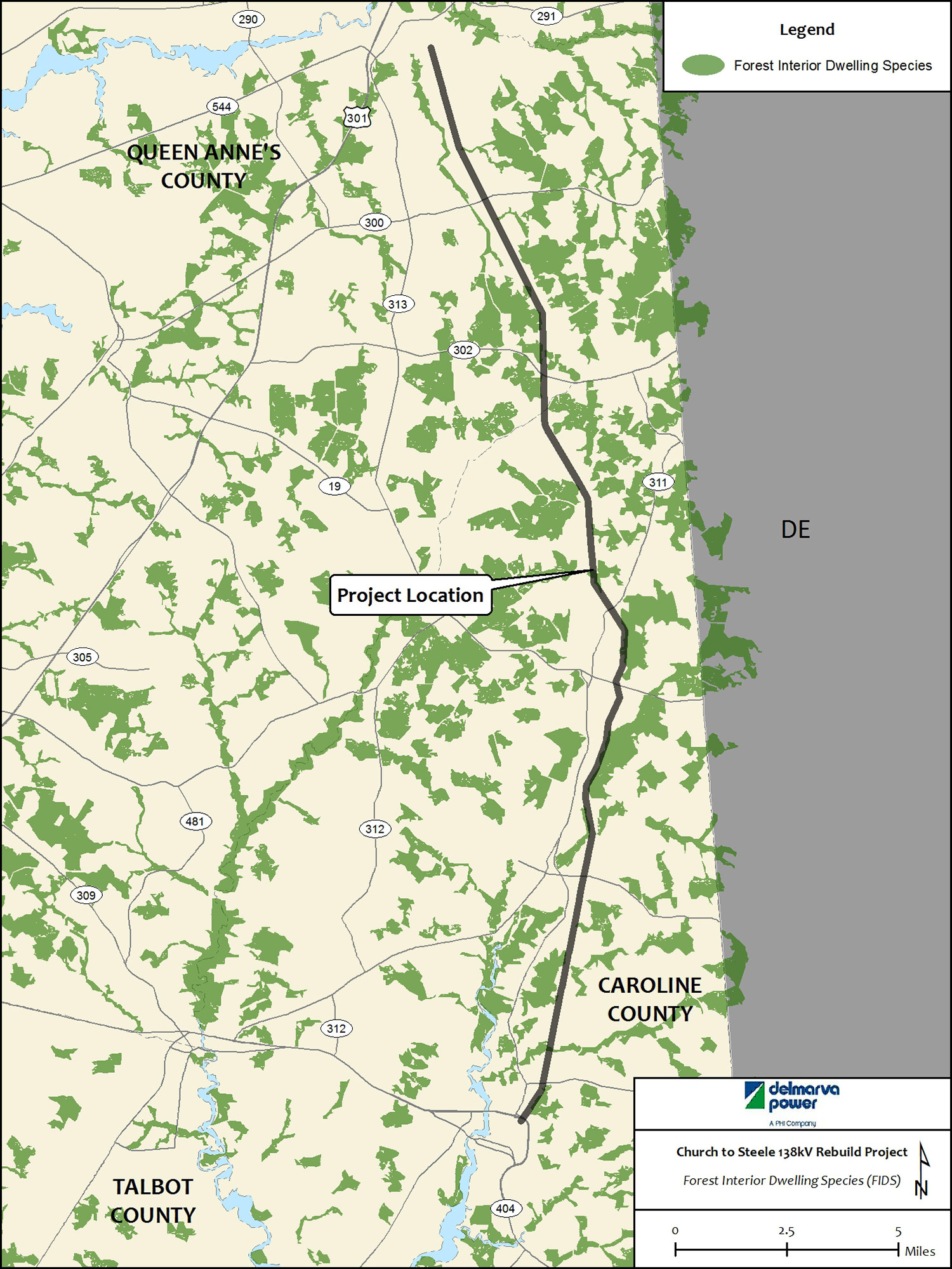
Wildlife
Field surveys confirm that the Project ROW is primarily active agriculture land with only relatively small areas dominated by herbaceous and or shrub vegetation, including wetlands and old successional fields. Potential habitat for Forest Interior Dwelling Species (FIDS), Colonial Nesting bird habitat, and waterfowl staging areas were not observed in the ROW. No bald eagle nesting sites were observed within the Project ROW. Delmarva Power identified three raptor nests within the Project ROW (Appendix N). In general, vegetation disturbance from the Project will be temporary and limited to construction vehicle access and structure installation. To minimize vegetation and habitat disturbance in wetlands, Delmarva Power will use temporary construction matting in wetlands. Delmarva Power will restore disturbed areas in vegetated upland areas to the existing conditions. The temporary disturbance of vegetation will not adversely affect wildlife such as mammals, reptiles, and amphibians ( Appendix F, Section 7.0).
Fisheries
The Project does not involve any in-stream work associated with Project rebuild activities. Two protected fish species are known to exist in two streams that traverse the Project ROW. Yellow Perch was found in Gravelly Branch and the Swamp Darter was found in Unicorn Branch. The Project involves crossing four streams, which cannot be avoided for access to the ROW. These stream crossings will be accomplished with the use of temporary construction mats or bank to bank bridging in accordance with Maryland Waterway Construction Guidelines so as to avoid adverse stream bank and streambed effects during the installation, operation, and removal of these bridges. All temporarily disturbed areas near streams will be stabilized and re-vegetated as soon as possible after disturbance. Stabilization and revegetation is key to avoiding sediment flow into nearby streams, which would adversely affect fish. With these measures, Delmarva Power anticipates that the Project will have only minor effects on stream water quality or fisheries (Appendix F, Section 8.0).
Air
Queen Anne's and Caroline Counties are currently designated as attainment areas for the US Environmental Protection Agency's (USEPA's) National Ambient Air Quality Standards (NAAQS) criteria pollutants. Therefore, criteria pollutants in the Project ROW are below the levels established by the NAAQS. The potential for the Project to affect local air quality is confined to emissions from construction equipment and the formation of dust during the operation of construction equipment. Construction activities will result in a negligible increase in suspended dust particles. Nonetheless, Delmarva Power will employ appropriate BMPs, such as dampening the dry disturbed areas to reduce the potential to generate suspended dust particles. Effects on air quality will be minor and limited to the temporary construction period (Appendix F, Section 10.0).
Noise
Noise effects from the proposed Project will be minor and limited to the temporary construction period. Project equipment operation will generate temporary moderate noise levels during construction. However, since most of the Project ROW is located on agricultural land, noise receptors such as residences, schools, and other facilities that might be sensitive to increases in noise levels are not located near temporary work areas ( Appendix F, Section 11.0).
RTE Species and Habitat
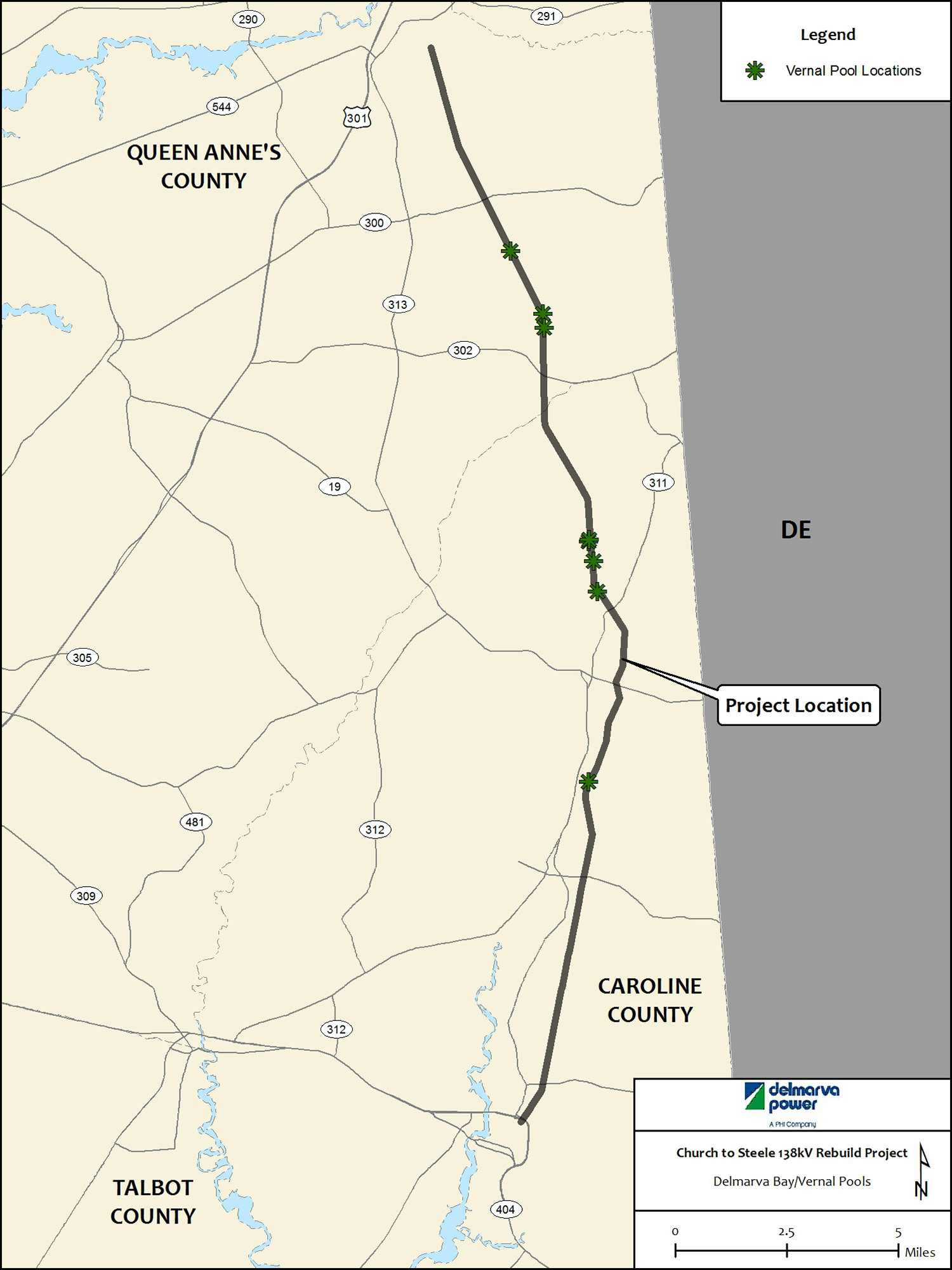
Consultation from DNR Wildlife and Heritage indicated the presence of potential populations and habitat for numerous federal RTE species within the Project ROW and within the vicinity of the Project. DNR Wildlife and Heritage requested detailed species specific surveys for the Eastern Tiger Salamander (Ambystoma tigrinum), the Barking Treefrog (Hyla gratiosa) and the plant species listed in Table 2.1-1. Delmarva Power is currently conducting the requested species surveys.
Prior to receiving a response from DNR Wildlife and Heritage to Delmarva Power's consultation request, Delmarva Power conducted targeted habitat suitability assessments in late 2013 and early 2014. The habitat suitability assessments identified several areas of Delmarva Bays (Vernal Pool) habitat near the Project ROW. Delmarva Bays have unique habitat areas that support several RTE plant and animal species. Delmarva Power consulted with DNR and USFWS to determine the requirements of the species-specific surveys in order to complete them during the appropriate survey season. Pending the results of these surveys in the Fall of 2014, Delmarva Power will work to further avoid and minimize the proposed structure locations and temporary work areas. Through this iterative process and adherence to the recommendations regarding BMP and construction practices within the vicinity of RTE species, the overall Project effect on RTE species will be minor (Appendix F, Section 9.0).
Non-tidal Wetlands
Delmarva Power identified 79 wetlands within the Project ROW, many of which included more than one wetland classification (Appendix M ). Wetland classifications that were identified within the Project ROW include: palustrine scrub-shrub and palustrine emergent wetland. Several wetlands were identified as Delmarva Bays (Vernal Pool). There are eight Wetlands of Special State Concern (WSSC) on or adjacent to the Project ROW.
Table 2.1-2 below describes the existing structures in wetlands and wetland buffers and the number of proposed structures in wetlands and wetland buffers. The avoidance and minimization process the number of structures located within wetlands has decreased. However, this has resulted in an increase in structures within the wetland buffers.
Equipment access and staging in wetlands will be conducted on temporary construction matting to avoid vegetation disturbance, soil compaction, and soil erosion. Mats will be removed and vegetation will be permitted to naturally reestablish. Through planning and use of BMPs during construction, Delmarva Power will minimize effects to wetlands. The project will result in approximately 9-acres (392,793 ft2) of temporary wetland impacts and 0.02-acre (737 ft2) of permanent wetland impacts. Project effects on wetlands are considered minor because of the minimal temporary and permanent impacts to wetlands resulting from access and work areas (Appendix F, Section 5.0).
2.1.3 Moderate Effects
The Project will not result in Moderate Effects to any resources. Delmarva Power does not propose expanding the ROW. Project construction effects will be confined to the existing ROW. After restoration and mitigation efforts, the Project is expected to have only Minor Effects on natural, socioeconomic, land use and cultural resources beyond those within the existing ROW.
2.1.4 Significant Effects
The Project will not result in Significant Effects to any resources. Delmarva Power does not propose expanding the ROW. Project construction effects will be confined to the existing ROW. After restoration and mitigation efforts, the Project is expected to have only Minor Effects on natural, socioeconomic, land use, and cultural resources beyond those within the existing ROW.
3. Environmental Protection Measures
Delmarva Power has conducted a thorough review and analysis of the proposed construction activities and effects on resources. Through the use of BMPs and A&M measures, Project effects are minimized. Delmarva Power has also identified and will implement applicable environmental resource protection measures for the Project. These measures have been identified from a range of standard practices and procedures including: Delmarva Power's BMP Manual (Appendix J); Erosion and Sediment Control Plans; MDE Wetland and Waterway authorizations; and USACE authorizations. These measures will be implemented as required by the Project approvals and Delmarva Power standards. Through the implementation of these measures, effects on the resources will be minimized. The environmental protection measures identified for implementation on this Project are described in detail in Appendix E.
3.1 Environmental Commitments
In order to proactively minimize potential effects from Project construction and operation, a number of environmental commitments are considered in Table 3.1-1. These commitments are consistent with applicable state, federal, and local regulations. The following measures are incorporated into the Project plans, as appropriate:
- Delmarva Power will access existing structures through the use of existing roads.
- The Project will not require any in-stream work. These features will be bridged, and erosion and sedimentation controls will be implemented to prevent the potential discharge of sediment to streams during construction. There are only unavoidable stream crossings proposed for the Project. Temporary crossings, in accordance with Maryland Waterway Guidelines, will be used to bridge/cross streams to avoid potential stream bank and streambed Project effects.
- All abandoned (existing) structures in wetlands will be removed and disturbed areas will be restored in accordance with BMPs and restoration requirements. Equipment access and staging in wetlands will be conducted on temporary construction matting to avoid vegetation disturbance, soil compaction, and soil erosion. Mats will be removed, and the area will be temporarily stabilized in accordance with BMPs to allow the natural vegetation to reestablish.
- Once the rebuilt Church-Steele line is operational, Delmarva Power will implement its Integrated Vegetation Management (IVM) program. Delmarva Power will employ the wire/border zone management approaches specified in Best Management Practices: Integrated Vegetation Management (IVM) on Electric Utility Rights-of-Way (most recent edition). The resultant vegetation clearances are to be in compliance with applicable North American Electric Reliability Corporations (NERC) and Federal Regulatory Commission (FERC) rules, guidelines, policies, procedures, and/or regulations.
- Regulatory compliance during construction activities will be evaluated and documented through implementation of Delmarva Power's established voluntary Environmental Monitoring program.
3.2 Environmental Monitoring
When the appropriate permits are received, an environmental monitoring manual will be developed to ensure the application of all BMPs for construction, and to ensure that the permitted activities are carried out in a manner consistent with the permit requirements. The environmental monitoring manual will contain a variety of information, including permits, permit drawings, frequently asked questions, environmental field inspection forms, inspection and maintenance forms, environmental incident forms, health and safety measures, and contact information for Delmarva Power personnel. The detailed information will ensure that construction personnel are aware permit conditions and will also ensure that the work will be undertaken and documented to the satisfaction of all stakeholders and in compliance with regulatory requirements.
Throughout the construction phase, a Delmarva Power contractor that specializes in environmental oversight will perform environmental monitoring services for the Project. The Environmental Monitor will observe construction activities and evaluate and maintain compliance with environmental permits, regulations, and other environmental commitments made by Delmarva Power. The Environmental Monitor will maintain and facilitate daily communication and coordination with Delmarva Power and the construction contractor regarding environmental compliance. In general, the Environmental Monitor's role will include the following responsibilities:
- Review of design plans to ensure that they meet permit requirements and that all practical avoidance and minimization efforts are incorporated.
- Routine construction monitoring to verify that the work is in compliance with permits and regulations.
- Recommendation of measures to keep the Project in compliance to Delmarva Power Construction Management.
- Completion of daily reports and weekly reports, as needed.
- Completion of NPDES post storm inspections.
Delmarva Power will use an "Environmental Monitoring Toolkit" to track environmental compliance on a daily basis. The Environmental Monitoring Toolkit is a web-based, password-protected online database that allows multi-user access to coordinate field activities, permit requirements, and permit compliance. The Environmental Monitor will enter data into the database, including the documentation of all preconstruction and construction activities (Appendix E, Section 3.0).
Appendix B - Consultation Letters
Consultation Letters
Appendix C - Project Plans
Project Plans
- Project Plans - May ERD submittal (86 MB)
- Project Plans - October ERD submittal (120 MB)
- May Plan and Profile (Image Files - 71 MB)
- Plan and Profile (Image Files - 38 MB)
- Plan and Profile (Vector Files - 52 MB)
Appendix D - Resource Mapping
Resource Mapping
Static resource maps are available below in .pdf format for download, print, or online viewing. Resource mapping is also viewable via the Interactive Map which allows you to display any combination of resources by using the layers panel within the map. Launch the Interactive Map
- Topographic (13 MB)
- Water Resources (35 MB)
- Wetlands (38 MB)
- Wildlife (45 MB)
- Soils (18 MB)
- Cultural (20 MB)
- Land Use (20 MB)
Appendix E - Project Construction Details
1.0 Avoidance and Minimization
The Delmarva Power & Light Company (Delmarva Power) employs a wide variety of techniques, activities, best management practices (BMPs), and work processes to avoid and/or minimize environmental impacts. These practices begin in the design and planning phases of a project and extend to construction and post-construction activities. Delmarva Power has an inclusive and thorough engineering and environmental evaluation and design process. Delmarva Power's Environmental Planning Department is integrated with its Transmission Line Engineering Department to ensure ongoing communication and planning during a project's life cycle. Working collaboratively allows the transmission engineers and environmental scientists to analyze a preliminary project design and to review and revise the design to avoid wetlands, areas of sensitive habitat, and other valuable natural resources. This integrated approach also allows the Project team to develop construction schedules that avoid impacts to Rare, Threatened or Endangered (RTE) species and to comply with waterway construction time-of-year restrictions to protect aquatic habitats.
Delmarva Power consults with the appropriate regulatory agencies and reviews publicly available environmental data sets to guide and direct field studies. Delmarva Power uses experts to conduct the appropriate field studies according to agency-preferred or required methodologies. Field study work for the Project included wetland delineation, RTE species habitat assessment, raptor nest surveys, and species-specific surveys. Through this approach Delmarva Power develops project specific avoidance and minimization measures that are used in tandem with Delmarva Power's programmatic avoidance and minimization measures.
1.1 Programmatic Avoidance and Minimization
Table 1.1-1 provides a list of typical programmatic environmental impact avoidance and mitigation measures employed by Delmarva Power for work along transmission line rights-of-way (ROWs). A list of BMPs is provided in Appendix D.
In addition to the programmatic avoidance and mitigation measures, Delmarva Power has developed Project specific commitments as shown in Section 3.0.
1.2 Project Specific Avoidance and Minimization
Table 1.2-1 provides a list of project specific avoidance and minimization measures that were developed based on the best available data that was available at the time of the submittal of the ERD.
2.0 General Construction Activities
The Project work area at each existing and proposed structure location is anticipated to be approximately 50 feet by 50 feet for intermediate structures and 100 feet by 100 feet for dead end structures. The projected work area at pulling locations/ optical ground wire (OPGW) splice points will be approximately 360 feet by 100 feet to provide space for additional puller-tensioning and cable roller equipment. Construction vehicles will enter the ROW on established access routes, in accordance with the Project Plans. Temporary composite matting will be installed in areas where wetlands and buffers must be crossed. Temporary bridges (stream bank to stream bank) will also be used for all stream crossings to avoid direct impacts to streams.
General construction in the work area will consist of the following basic steps and sequence:
- Install required erosion and sediment controls.
- Install required temporary matting and temporary bridges for stream crossings.
- Deliver and assemble structures to the work area.
- Install direct buried steel or wood structures or construct concrete caisson foundations with anchor bolt assembly.
- At cured concrete foundation locations, install steel structures on anchor bolt assembly.
- Pull conductor.
- Remove existing wood structures.
- Complete final restoration of work site.
- Remove any erosion and sediment controls.
The above activities are described in further detail in the sections below.
2.1 Lay-down/Staging Areas
Lay-down and/or staging areas are used for the short-term storage of construction supplies and equipment. These areas are typically located away from sensitive environmental resources in developed or pre-disturbed, off-ROW areas including paved or graded lots and farm fields. If pre-disturbed laydown areas are not available within a reasonable distance from ROW work areas, potential sites will be identified and an environmental review of these sites will be performed, including characterizing natural resources, conducting resource avoidance and minimization procedures, and identifying required environmental permits.
2.2 Construction Ingress/Egress
In accordance with Maryland Department of the Environment (MDE) and soil conservation district erosion and sediment control requirements, a stabilized construction entrance or temporary matting of construction entrances will be required where vehicles or equipment enter or leave the site at an existing public road or highway. Stabilized construction entrances or a county-approved alternative will be employed at applicable ROW road crossings prior to access and construction in the ROW. Temporary stabilized construction entrances are generally established using aggregate stone placed over geotextile fabric at the edge of pavement into the ROW. The stabilized construction entrance is a BMP employed to minimize dirt or other contaminants from entering public roadways. Existing farm roads that Delmarva Power will use for ingress and egress will be stabilized as necessary based on field conditions and landowner requirements. The placement of stone or similar fill material may be needed to reinforce private access roads based on field conditions.
2.3 Erosion and Sediment Controls
An erosion and sediment control plan will be implemented to minimize Project impacts to the surrounding environment. The plan is required by Caroline and Queen Anne's County regulations and will be reviewed and approved by Caroline and Queen Anne's County Soil Conservation District staff prior to the start of construction activities in the Project ROW to ensure that all requirements are met. If the county-approved erosion and sediment control plan includes a limit of disturbance greater than one acre, Delmarva Power will complete the Notice of Intent (NOI) form as required for the Maryland General Permit for Stormwater Associated with Construction Activity. The erosion and sediment control plan will incorporate multiple environmental protection measures/BMPs based on the specific site conditions and the various activities proposed during each construction stage. Monitoring of the BMPs during construction will be managed by Delmarva Power's Environmental Monitoring Program. A complete list of BMPs that may be employed during this Project is provided in Appendix J.
2.4 Stream Crossings
Existing access corridors, roads, and culvert crossings will be used for access to structure locations to avoid and minimize potential effects on streams and waterways. Stream crossings will be avoided during construction activities whenever practical and feasible.
For unavoidable stream crossings, where feasible, temporary bank-to-bank bridging will be installed for construction vehicles to cross watercourses and avoid or minimize stream bank and streambed effects in accordance with Maryland Waterway Construction Guidelines, MDE Waterway Authorizations, and the Delmarva Power BMP manual (Appendix J). This will help to minimize the effect on natural water flow of the stream and not impede the movement of aquatic life.
2.5 Temporary Mat Placement
The construction process will be sequential, proceeding along the ROW using existing access and minimizing soil disturbance. Where applicable, temporary construction mats will be used for access and equipment staging in wetlands. These mats will be utilized to prevent ruts, changes in micro-topography or drainage, and adverse effects on cover vegetation. The mats will be interlocking composite matting, as required by the Delmarva Power BMP manual (Appendix J). Mats in active agricultural areas and uplands with significant slope will be added as needed based on field soil conditions at the time of construction. Mats will remain in place for the duration of all work activities in each section of ROW. The movement and placement of mats will be coordinated with the crews as stages of construction are completed. All matting will be removed at the earliest opportunity and in accordance with time-of-year restrictions outlined by the MD DNR. The Project plans indicate where mats will be required for access and equipment staging (Appendix C).
2.6 Structure Installation
The existing structures are wooden H-frame with either two or three poles with an average span width of approximately 710 feet. There are 188 existing structures associated with the transmission line (19 Three-Pole Angle Structures and 169 Two-Pole Structures) and three structures associated with the Oil City Tap (One Two-Pole Structure and two Three-Pole Structures). The proposed rebuild will include 187 Structures associated with the transmission line and two structures associated with the Oil City Tap. Therefore, in total the rebuild will result in a net loss of one structure on the transmission line, and one structure on the Oil City Tap. There will be 145 tangent structures with steel caisson foundations, ten running angle structures will drilled pier foundations, 30 dead-end structures with drilled pier foundations, 1 dead-end structure on the tap with a drilled pier foundation, and three switch structures (one on the tap) comprised of direct embedded poles.
There are three structure foundation types designed for the Project. The general installation method for each foundation type is as follows:
- Direct embed--Involves the auguring or excavating of a hole to the design depth, placing the new steel structure into the ground, and backfilling with the augured material or suitable crushed stone.
- Steel caisson foundation--Involves vibrating the hollow caisson into the ground and excavating the top several feet of soil. The structure is then mounted to the caisson and backfilled with concrete and excavated soil.
- Drilled Pier foundation--Involves the auguring to the design diameter and depth for a drilled pier or round hole and the installation of a reinforced steel cage and anchor bolts into the excavation. Concrete is then poured into the hole of the foundation, and the structure is bolted to the completed foundation.
The direct embed diameter will be approximately three feet. The caisson foundations supporting the tangent structures will be approximately 7 foot in diameter. The drilled pier foundations will be approximately 6.5 to 11.0 feet in diameter. Depending on topography, structure spans, and clearances, structure heights will range between 95 and 125 feet above ground level. Most structures are delivered in multiple pieces and assembled on location with a crane.
Crews typically spot structure pieces on location with a small crane or derrick. Foundation crews follow to either auger or excavate for direct buried structures or prefabricated caissons, or construction concrete anchor bolt foundations. Framing crews are then engaged to assemble installing hardware, insulators, and conductor running blocks. When possible, the insulators, hardware, and running blocks are attached prior to the time-frame of setting the structure. A setting crew follows the framing crew to install or set the structure in place. Generally, the framed-out structure can be installed in one or two lifts. A digger derrick and a support truck will typically be used for access to the work areas to deliver the structure, excavate, assemble the structure, and set the new structure. During the structure installation, crews will install any required grounding and complete the grounding attachments at the structure. The areas around each structure will be backfilled with soil removed during excavation, and enough additional excavated soil will be placed over the backfilled areas to compensate for any potential settling. Depending on permit stabilization requirements, the excess soil from excavation will be spread evenly in upland areas of the ROW around the structures or removed and disposed of at an approved site. In accordance with Delmarva Power's construction BMPs, excess soil will not be broadcast in wetlands or wetland buffers.
2.7 Conductor Installation
Conductor (wire) pulling will be performed in accordance with the Institute of Electrical and Electronics Engineers (IEEE) Guide to the Installation of Overhead Transmission Line Conductors, IEEE Std. 524-1992. To the extent feasible, pulling and tension sites will be located outside of wetlands. If pulling and tension sites are required in wetlands equipment staging areas will be matted within the existing ROW. Conductors will be pulled using individual take-up reels, with ropes strung along the steel structures. Pulling assemblages will be installed during the installation of the pole insulator attachments.
2.8 Cleanup and Restoration
The existing wood will be removed from the Project ROW and disposed of in accordance with Delmarva Power BMPs. During construction, BMPs will be used for materials storage, waste collection, and spill prevention. Delmarva Power will remove mats when construction activities are completed within that Project segment. Upon removal of the mats, vegetation will naturally reestablish. Delmarva Power will seed and mulch areas as required by the erosion and sediment control permit. Surplus construction materials will be removed from the Project ROW on completion of construction activities.
3.0 Environmental Monitoring
Delmarva Power's environmental monitoring activities are divided into two phases: Preconstruction Environmental Monitoring and Construction Environmental Monitoring.
The preconstruction phase involves participating in the Project design review, Delmarva Power meetings, and agency meetings. During the preconstruction phase, the Environmental Monitor will be involved in the review of the ongoing preconstruction process. The Environmental Monitor will attend meetings with regulatory agencies and Delmarva Power contractors and provide input to verify compliance as necessary. These meetings will also present an opportunity to explain the role of the Environmental Monitor to contractors and other stakeholders. There will be ongoing review of the Project design at the various stages of the preconstruction period, and the Environmental Monitor will provide recommendations to Delmarva Power and the agencies for compliance with permit conditions. Typical reviews include the following:
- Constructability within permit conditions
- Additional avoidance and minimization opportunities
- Sensitive environmental resources
- Hydraulics and hydrology
- Temporary access roads
- Temporary matting and culverts
- Environmentally sensitive construction techniques
- Implementation of erosion and sediment controls
- Stabilization, restoration, or replacement of temporary impacts
- Temporary matting in wetlands and wetland buffers
- Air quality
- Potential noise
- Review of construction phasing
- Review of design changes
- Assessment of construction lay-down/staging areas
- Photo documentation of preconstruction conditions
The construction environmental monitoring phase will consist of day-to-day on-site field monitoring and will:
- Identify, address, coordinate, and oversee applicable permit issues by working jointly with the Delmarva Power Environmental Project Engineer/Scientist and Delmarva Power Construction Management Representative (e.g., avoidance and minimization, permit conditions, mitigation requirements, and permit compliance).
- List and prioritize sensitive construction areas and activities to forecast and prevent potential problems before they occur.
- Maintain high visibility to the contractors/public.
- Complete inspections of construction areas to ensure compliance with plans, specifications, special provisions, and environmental commitments and permits.
- Include construction reports, which may document the following:
- Protection of existing vegetation and habitat areas
- Erosion and sediment control measures
- Water quality observations
- Landscaping and reforestation activities
- Field changes
- Weather conditions
- Maintain environmental construction reports, environmental memoranda, and daily reports that summarize the issues, actions taken, and actions needed.
- Prepare for and lead periodic regulatory agency site reviews presenting recent construction activity, status of wetland/waters and other resource impacts, locations of past and future impact areas, problem areas, and actions requested/needed.
- Immediately inform Delmarva Power of any noncompliance issues and document the status of compliance and actions requested in the daily log for that day and subsequent days until compliance is achieved.
- Respond to any environmental problem or issue that arises on the construction site.
- Assist Delmarva Power in responding to any unforeseen environmental and community issues that may arise because of the dynamics of the construction Project.
- Maintain records of all Project-related environmental documents, design plans and reports, and final construction drawings at the Project field office.
- Report all environmental concerns and issues from the public to the Delmarva Power Construction Manager and Environmental Manager.
- Include complete construction reports, which may document the following:
- Protection of existing vegetation and habitat areas
- Erosion and sediment control measures
- Water quality observations
- Landscaping and reforestation activities
- Field changes
- Weather conditions
- Maintain environmental construction reports, environmental memoranda, and daily reports that summarize the issues, actions taken, and actions needed.
4.0 General Construction Schedule
The proposed construction start date for the Project is February 2016. The construction schedule and sequencing for the Project will be developed based on engineering, design, transmission system and outages. The proposed in-service date for the Project is May 2017. The proposed construction start date for the Project is February 2016. The construction schedule and sequencing for the Project will be developed based on engineering, transmission system, and environmental constraints. The proposed in-service and completion date for the Project is May 2017.
5.0 Cross-Sections
Click Here to view current cross-sections developed based on the best available engineering data that was available at the time of the submittal of the ERD.
Appendix F - Natural Resource Technical Report
1.0 Geology
This section describes the geologic and mineral resources in the Project area. Potential impacts were assessed using the Maryland Geological Survey (MGS) and the United States Geological Survey (USGS) as well as other sources referenced at the end of this Section. To identify potential mineral resources in the Project area, a search of the Maryland Department of the Environment (MDE)-listed surface mine sites was performed.
1.1 Existing Conditions
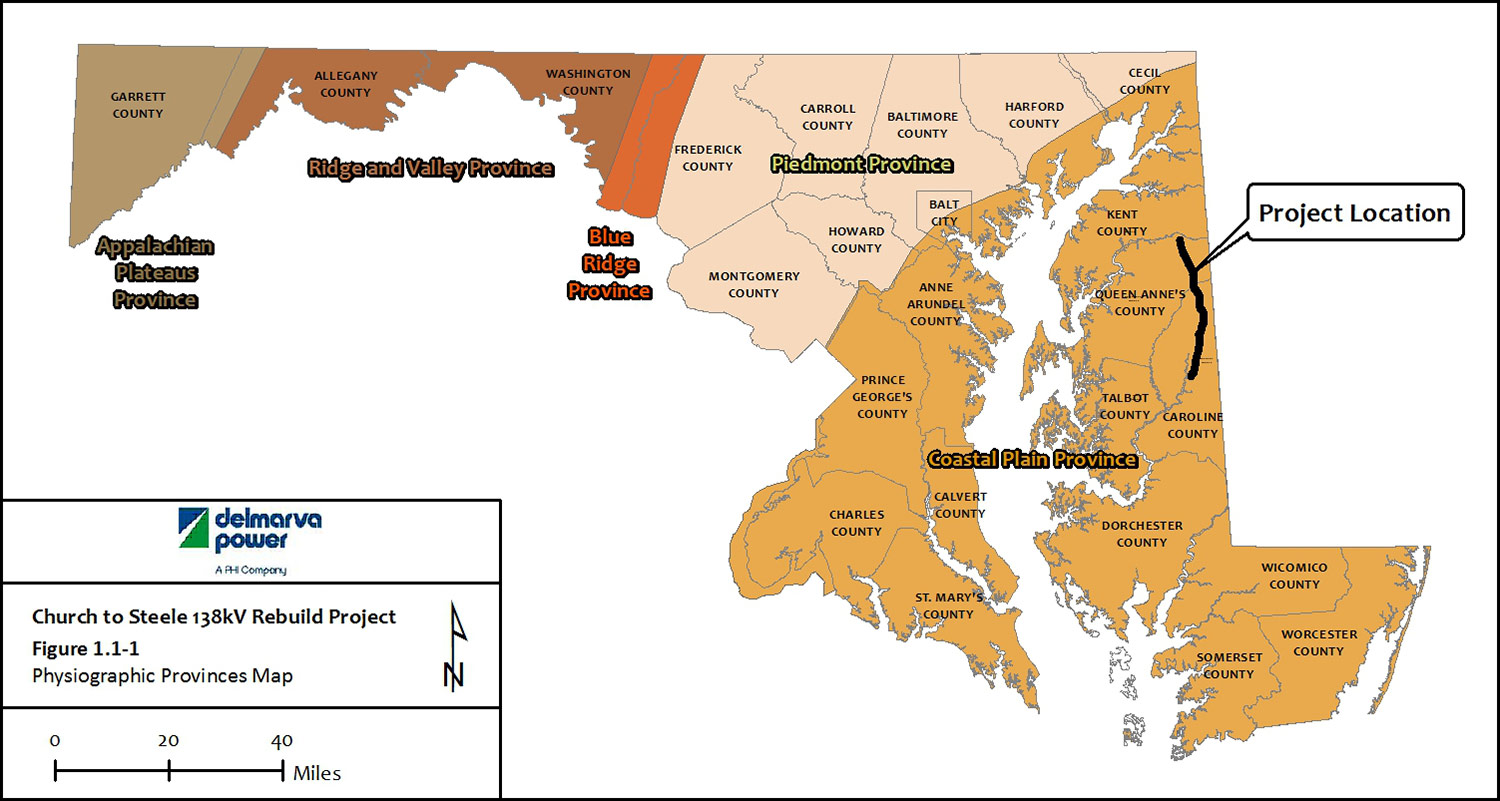
The Project area is within Queen Anne's County and Caroline County, and is entirely within the Atlantic Coastal Plain physiographic province (Figure 1.1-1). Physiographic provinces are landform regions that are characterized by elevation, topography, lithology, and geologic structure. There are five provinces located in Maryland (from west to east): the Appalachian Plateaus, the Ridge and Valley, the Blue Ridge, the Piedmont, and the Coastal Plain. There is an additional province located off the coast of Maryland call the Atlantic Coastal Shelf Province. The Fall Zone represents the approximate boundary between the Coastal Plain and the Piedmont Plateau. A description of the geology of the area and known mineral resources is provided below.
1.1.1 Geologic Resources
The Coastal Plain consists of an "eastward thickening wedge of sediments underlain by unconsolidated sediments including gravel, sand, silt, and clay, which overlaps the rocks of the eastern Piedmont along an irregular line of contact known as the Fall Zone" (Ref. 1-1). The unconsolidated sediments were deposited primarily in marine, shallow water, or fluvial environments. Underlying these sediments is Precambrian crystalline rock (gneiss or gneiss and schist) that dips to the southeast. A thin layer of windblown silts covers the land surface. The windblown deposits may have been reworked by streams and moving water in some areas (Ref. 1-2).
Older landforms of the Coastal Plain are found to the west; whereas, younger sediment deposits are found to the east and southeast. Surface geology to the west of the region began to form during the Cretaceous period of the Mesozoic era. The tidal marshes and barrier island dunes found to the east were primarily formed during the Quaternary period (Ref. 1-3). Topography throughout the region is generally flat. For example, the highest elevation in Queen Anne's County is located in the vicinity of Starr and is 87 feet above sea level, and the highest location in Caroline County is 79 feet above sea level just west of Henderson. The lowest parts of the county are tidal marshes, which are at or just above sea level (Ref. 1-4).
1.1.2 Mineral Resources
Sedimentary, weathering, and erosional processes that formed the Coastal Plain have resulted in the deposition of mineral resources that include sand, gravel, clay, and shale (Ref. 1-2). Sand and gravel are used as aggregate materials in the construction industry. Clays are also used in brick manufacturing. Based on a review of MDE's non-coal surface mine maps, 13 mineral production sites are within Queen Anne's County and 21 mineral production sites are found in Caroline County. Five sites are within one mile of the Project ROW as presented on the soils mapping in Appendix D (labeled as "Surface Mines") (Ref. 1-5). There are no mineral production sites located within the Project ROW. The property owners of the five sites within one mile of the Project ROW are listed in Table 1.1-1 and shown on Appendix D, Figure D-5: Soils.
1.2 Effects Analysis
1.2.1 Initial Effects Assessment
The Project construction activities will be conducted within the existing electric transmission ROW and involve excavation for the installation of approximately 189 steel structures with foundations ranging in depth below grade to a maximum of 35 feet. There are no known unique geological features or mineral mining operations in the Project work area (Ref. 1-1).
1.2.2 Avoidance and Minimization Evaluation
Since there are no mineral resource operations in the Project ROW, avoidance and minimization evaluations are not applicable. The scale and scope of the Project will not require any avoidance and minimization measures associated with geologic and mineral resources.
1.2.3 Final Effects Determination
The proposed removal of old structures and the installation of new structures will have no effect on geologic features and any mineral mining sites within Queen Anne's and Caroline Counties.
1.3 References
1-1 Maryland Geological Survey (MGS). Maryland Geology. Accessed December 17, 2013. http://www.mgs.md.gov/esic/brochures/mdgeology.html
1-2 MGS. 2008. Explanatory Text for the Physiographic Map of Maryland. Baltimore, MD. Prepared by James P. Reger and Emery T. Cleaves.
1-3 Hanner, Charlie, Susan Davis, and James Brewer (NRCS). Formation and General Geology of the Mid-Atlantic Coastal Plain. Accessed December 17, 2013. http://eppg-pdc-sprsummer2012.wikispaces.com/file/view/Formation+and+General+Geology+of+the+Mid+Atlantic+Coastal+Plain-1.pdf
1-4 MGS. 2008. Highest and Lowest elevations in Maryland Counties. Accessed January 14, 2014. http://www.mgs.md.gov/esic/fs/fs1.html
1-5 MDE. 2013. Mining in Maryland - Maps. Accessed January 14, 2014. http://www.mde.state.md.us/programs/Land/mining/Mapping/Pages/Programs/LandPrograms/mining/mapping/index.aspx
2.0 Potential Contaminated Sites
2.1 Existing Conditions
This section summarizes a review of federal and state regulatory compliance databases and records performed by Environmental Data Resources, Inc. (EDR), including environmental site investigations, compliance information, and the status for listed sites within a one-mile radius of the Project ROW (search area). The Project was evaluated with respect to the potential for encountering contaminated soils during construction activities.
2.1.1 Federal Records
The EDR DataMap Corridor Study, provided in Appendix L, included review of properties and sites within a one mile radius of the Project ROW (search area). The following records and databases related to potential soil contamination were investigated:
- Resource Conservation and Recovery Act Small Quantity Generator (RCRA-SQG) Sites - Includes sites that generate, treat, store, and/or dispose of hazardous materials in quantities between 100 kilograms (kg) and 1,000 kg per month.
- One RCRA-SQG was identified within the search area.
- Facility Index System (FINDS) Sites - FINDS contains both facility information and "pointers" to other sources of information that contain more detail. The source of this database is the USEPA/ NTIS.
- One FINDS site was identified within the search area.
2.1.1 State Records
- State Hazardous Waste Sites (SHWS) - Priority sites planned for cleanup using state funds (state equivalent of Superfund) are identified along with sites where cleanup will be paid for by potentially responsible parties. The data come from the MDE's Notice of Potential Hazardous Waste Sites list. These sites may or may not already be listed on the federal Comprehensive Environmental Response, Compensation, and Liability Information System (CERCLIS) list.
- One SHWS site was identified within the search area.
- MDE's Oil Control Program (MD-OCP) Cases - Include sites at which oil-related activities are monitored by the MDE.
- 13 MDE-OCP Case sites were identified within the search area.
- Resource Conservation and Recovery Act Underground Storage Tank (RCRA UST) sites - USTs are regulated under Subtitle I of RCRA. The data comes from the MDE's listing of USTs reported in Maryland.
- Three UST sites were identified within the search area.
- Maryland Historical Underground Storage Tank (HIST UST) sites - Include leaking underground storage tank sites listed by the MDE prior to 1999.
- Two HIST UST sites were identified within the search area.
- Maryland Lead Registry (LEAD) - includes rental properties with current lead inspection certificates.
- One LEAD site was identified within the search area.
- Recovered Government Archive State Hazardous Waste Sites (RGA-HWS) - provides a list of SHWS incidents derived from historical databases and includes many records that no longer appear in current government lists.
- One RGA-HWS site was identified within the search area.
Table 2.1-1 summarizes the results of the EDR data search of federal, state and local records conducted for the Project. Appendix D, Figure D-5 provides an overview of the EDR sites.
2.2 Effects Analysis
2.2.1 Initial Effects Assessment
The entire length of the Project will be within a ROW currently used for electric transmission that does not contain any known contaminated sites based upon the EDR Radius report. Therefore, the Project will have no impact on contaminated sites because there are none identified within the impacted area.
2.2.2 Avoidance and Minimization Evaluation
All construction activities outside the Project ROW (laydown areas, access roads) will be in locations chosen in order to avoid any known contaminated sites. If hazardous substances in soil are encountered during excavation as determined by odor, sheen, or change in soil characteristics, work will be stopped until the soil is characterized, and the necessary health and safety measures are implemented. If excavation of hazardous materials is required, soil will be handled, transported, and disposed of by Delmarva Power waste contractors in accordance with the Delmarva Power BMP Manual, local, state, and federal regulations. Procedures to address any encountered contamination will be included in the Project-specific construction manual.
2.2.3 Final Effects Determination
Based upon the results of the EDR radius report, it is anticipated that the Project will have no effect on contaminated sites. There are no contaminated sites within the Project ROW, and the sites within the Project area are being avoided in the Project Plans for laydown areas and access roads.
Multiple facilities with potential contamination concerns were identified within a one mile radius of the Project ROW. Due to the distance of these sites from the ROW, it is unlikely that contamination at any of the listed sites has impacted soils in the Project ROW. The closest contaminated site to the Project ROW is a MD LEAD contamination site located at 26290 Boyce Mill Road. This site is listed in the EDR report as having passed an inspection in 2009 and is located over 400 feet from the Project ROW.
2.3 References
2-1 EDR Data Map Corridor Study Report. "Churchtosteelecenterline". January 27, 2014.
3.0 Soils and Sediment
This section describes existing soil characteristics within and adjacent to the Project ROW, and evaluates the effect of Project construction activities on soils. Soils were reviewed using information provided by the Natural Resource Conservation Service (NRCS) and soil series data layers presented on Geographic Information System (GIS) overlay maps. All soil types within the ROW were identified and summarized in Table 3.1-1. Soils in the ROW were evaluated based on total area covered by that soil type, each soil's hydric rating, water, and wind erodibility.
3.1 Existing Conditions
3.1.1 Mapped Soils
As previously stated, the Project ROW is located within the Coastal Plain Province. The Coastal Plain Province is underlain by a wedge of unconsolidated sediments including gravel, sand, silt, and clay, which overlaps the rocks of the eastern Piedmont along an irregular line of contact known as the Fall Zone (Ref. 3-6). The Project ROW is located in a relatively flat area between the Delaware Bay and the Chesapeake Bay. NRCS's soil survey geographic (SSURGO) databases were used to create a soil association inventory map for the Project ROW. Soil associations and soil units are developed from distinctive soil characteristics and patterns in the landscape and soil profile. An association normally consists of one or more major soil units (from which it is named) and at least one minor soil unit. The Project ROW consists of 52 soil units or series. Appendix D, Figure D-5 Soils Mapping illustrates the location of each soil series identified within the Project ROW (Ref. 3-1). Table 3.1-1 generally describes each major soil series occurring within the Project ROW, including hydric soils, which are generally associated with wetland soils. Hydric soil is defined as "soil that forms under conditions of saturation, flooding, or ponding long enough during the growing season to develop anaerobic conditions in the upper part" (Ref. 3-2). The Hydric Rating column within Table 3.1-1 identifies soil series as hydric based on the NRCS Maryland Hydric Soils List (Ref. 3-4 and 3-5).
Approximately 79 percent of the soils in the Project ROW are in active agricultural use. As discussed in Section 4, soils within the Project ROW will be subject to disturbance during equipment access and staging, structure replacements, and the removal of old structures. Site specific disturbance, and potential soil erosion and sedimentation will depend on existing grades and presence or absence of vegetation.
A baseline evaluation using NRCS's SSURGO database was completed to identify existing soil conditions that could be adversely affected during construction and operation. The following soil characteristics were evaluated:
- Highly erodible soils - soils prone to high rates of erosion when exposed to wind or water when vegetation has been removed.
- Hydric soils - soils designated by NRCS that, under normal conditions, are saturated for a sufficient period of time during the growing season to support the growth of plants that thrive in wet conditions (hydrophytic vegetation) (Ref. 3-1).
Table 3.1-1 also provides NRCS erosion factors for the Project area soils. The K values listed in the table represent the susceptibility of soils to erosion from stormwater runoff. Low K values (.02 to .15) represent higher soil stability; whereas, high K values represent the most erodible soils (greater than 0.4). Only five of the 52 soil units in the Project area have K values above 0.4, and 22 of the 52 soil units have K values at or below 0.15. Wind erodibility of Project area soils is also listed in the table, on a scale between one and eight. On the wind erodibility scale, lower values represent highly erodible soils and higher values represent soils that are resistant to wind erosion. Most of the wind erodibility values in the Project ROW are between five and two, showing that the area is moderately prone to wind erosion.
Actual soil conditions at any location may vary from the generalized soil types/complexes mapped. Soils vary in their susceptibility to erosion. The removal of soil through water or wind erosion is of concern whenever soil is exposed during construction activities. Soils within the ROW that are susceptible to wind and/or water erosion are presented in Table 3.1-1.
3.1.2 Prime Farmland Soils
Prime Farmland Soil, as defined by the USDA, is land that has the best combination of physical and chemical characteristics for producing food, feed, forage, fiber, and oilseed crops, and is also available for these uses (the land could be cropland, pastureland, rangeland, forest land, or other land, but not urban built-up land or water). The soils are of the highest quality and can economically produce sustained high yields of crops when treated and managed according to acceptable farming methods. Very specific technical criteria were established by Congress to identify prime farmland soils. In general, the criteria reflects adequate natural moisture content; specific soil temperature range; pH between 4.5 and 8.4 in the rooting zone; low susceptibility to flooding; low risk to wind and water erosion; minimum permeability rates; and low rock fragment content (Ref. 3-5). Soil types identified as Prime Farmland include all of the mapped areas for these soils; however, some soil types might be identified as Prime Farmland as long as certain agricultural practices are currently being met (i.e., only if being irrigated). Eastern Shore counties have a higher than average percentage of prime soil, approximately 28% compared to the rest of Maryland which is approximately 19% (Ref. 3-3). Within the Project area ROW, there are approximately 444 acres of prime farmland soils (Table 3.1-2).
3.1.3 Farmland of Statewide Importance
Farmland of Statewide Importance, as defined by the USDA, is land, in addition to prime and unique farmland, that is of statewide importance for the production of food, feed, fiber, forage, and oil seed crops. Criteria for defining and delineating this land are determined by the appropriate state agency or agencies. Generally, additional farmlands of statewide importance include those that are nearly prime farmland and that economically produce high yields of crops when treated and managed according to acceptable farming methods. Some may produce as high a yield as prime farmlands if conditions are favorable. In some states, additional farmlands of statewide importance may include tracts of land that have been designated for agriculture by state law (Ref. 3-5).
3.2 Effects Analysis
3.2.1 Initial Effects Assessment
The initial effects assessment involved overlaying the Project ROW on available GIS NRCS Soil Survey and Prime Farmland soils data layer on recent GIS aerial photography. Soils within the Project ROW will be subject to disturbance during construction activities. Site specific disturbance, and potential soil erosion and sedimentation will depend on existing grades and the presence or absence of vegetation. Minor, short-term impacts to soils in the Project ROW may result from Project construction activities. Table 3.2-1 summarizes the estimation of temporary disturbance of Prime Farmland and Farmland of Statewide Importance soils within the Project ROW.
3.2.2 Avoidance and Minimization Evaluation
Soil disturbance associated with construction equipment access will be minor because, to the extent possible, Delmarva Power will use existing access roads, farm roads, and public roads to reach the Project ROW. In the Project ROW, Delmarva Power will phase construction activities to minimize the amount of construction access through each work area and stabilize work areas as construction is completed. Site specific disturbance and potential soil erosion and sedimentation will depend on existing grades and presence or absence of vegetation, as well as the appropriate use of erosion and sediment control barriers and BMPs. In areas of wet soil, there is a potential for construction equipment to disturb the soil through compression and the creation of ruts. Measures to reduce potential impacts in these areas will include the placement of temporary mats to support construction equipment and minimize soil disturbance. In general, soil erosion in the ROW during construction will be minimized using MDE and County-approved BMPs including erosion control barriers and soil stabilization measures. All soil-disturbing activities will comply with sediment and erosion control regulatory requirements. There will be several off-site lay-down/staging areas spaced along the ROW to facilitate construction phasing, equipment parking, and materials storage.
3.2.3 Final Effects Determination
Project effects on soils are considered minor because the majority of the proposed work areas are relatively level and actual excavation areas will be confined to small areas near existing structures. Short term effects from soil disturbance resulting from access will be temporary and will be minimized through BMPs and sediment and erosion control requirements. The Project will not have a long term effect on soils in the Project ROW.
3.3 References
3-1 U.S. Department of Agriculture (USDA) Natural Resources Conservation Service (NRCS). 2006. Digital General Soil Map of U.S. Shapefile. 2006.
3-2 USDA NRCS. 2011. Hydric Soils-Overview. Accessed December 31, 2013. http://www.nrcs.usda.gov/wps/portal/nrcs/detail/soils/use/?cid=nrcs142p2_053985 .
3-3 USDA NRCS Maryland. 2014. NRI Information/Prime Farmland. Accessed May 8, 2014. http://www.nrcs.usda.gov/wps/portal/nrcs/detail/md/technical/dma/nri/?cid=nrcs144p2_025681
3-4 USDA NRCS. Soil Survey Geographic (SSURGO) database for Caroline County, Maryland, published 2010.
3-5 USDA NRCS. Soil Survey Geographic (SSURGO) database for Queen Anne's County, Maryland, published 2010.
3-6 Maryland Geological Survey. Maryland Geology. Accessed December 17, 2013. http://www.mgs.md.gov/esic/brochures/mdgeology.html
4.0 Water Resources
This section describes the existing water resources identified within the Project ROW and analyzes the potential effect of the Project on these resources. Water resources evaluated in this section include surface water and its designated uses, water quality classification criteria, Maryland's anti-degradation policy, scenic and wild rivers program, floodplains, and the presence or absence of local groundwater wells. Delmarva Power identified the water resources within the Project ROW and conducted a detailed impact analysis. Upon identification of potential impacts to water resources, Delmarva Power also conducted an Avoidance and Minimization (A&M) analysis to identify measures to avoid and minimize impacts to water resources.
4.1 Existing Conditions
To evaluate the effect of Project construction on water resources, Delmarva Power reviewed stream data including references from USGS, Maryland Department of Natural Resources (MD DNR), and MDE. To identify potential water resources in the Project area, a search of MDE-listed surface waters and water quality status (Designated Use and Tier) was also performed. The study area for water resources includes the area within the Project ROW and surrounding watersheds in Appendix D. A description of the existing water resources in the Project ROW is provided below.
The Project is located within the Upper Chester River, Tuckahoe Creek and Upper Choptank River Watersheds. After reviewing MDE tidal mapping and field delineations, it was determined there are no tidal waters within the Project ROW.
4.1.1 Surface Water
As shown on Figure 4.1-1, the Project ROW traverses three Maryland Hydrologic Unit Code (HUC)-8 digit watersheds -- Upper Chester River, Tuckahoe Creek, and Upper Choptank River. All three watersheds drain to the Chesapeake Bay. The Upper Chester River watershed is part of the Upper Eastern Shore Tributary Basin, while the Tuckahoe Creek and Upper Choptank River watersheds are part of the Choptank River Tributary Basin.
According to the USGS National Hydrography Dataset (NHD) GIS layer, there are 12 named blue-line streams and 320 unnamed reaches within the one mile buffer of the ROW (Ref. 4-13) associated with these watersheds. Delmarva Power obtained GIS stream data layers, provided by MD DNR (Ref. 4-14), and confirmed the presence or absence of streams and tributaries during wetland delineation. The Water Resources Mapping (Appendix D, Figure D-2) and the Project Plans (Appendix C) depict the field delineated water resources. The Project ROW crosses the following USGS mapped streams:
- Unicorn Branch
- Oldtown Branch
- Broadway Branch
- Choptank River
- Tubmill Branch
- Spring Branch
- Little Gravelly Branch
- Chapel Branch
Field surveys were conducted in November 2013 and February 2014, and streams within the ROW were located and characterized. Stream characterization data is presented in the "Wetland Delineation Report" provided in Appendix M, and summarized in Table 4.1-1 as follows.
Non-tidal streams are classified using these definitions (Ref. 4-12):
- Ephemeral - An ephemeral stream has flowing water only during, and for a short duration after, precipitation events in a typical year. Ephemeral streambeds are located above the water table year-round. Groundwater is not the source of water for the stream. Runoff from rainfall is the primary source of water for stream flow.
- Intermittent - An Intermittent stream has flowing water during certain times of the year, when groundwater provides water for stream flow. During dry periods, intermittent streams may not have flowing water. Runoff from rainfall is a supplemental source of water for stream flow.
- Perennial - A perennial stream has flowing water year-round during a typical year. The water table is located above the streambed for most of the year. Groundwater is the primary source of water for stream flow. Runoff from rainfall is a supplemental source of water for stream flow.
In addition to MDE and US Army Corps of Engineers (USACE) regulations, Caroline and Queen Anne's Counties have stream and stream buffer regulations. Caroline County Code requires that all perennial streams have a 100-foot stream buffer and intermittent streams have a 25-foot stream buffer (Ref. 4-16). Additionally, Queen Anne's County Code requires that all perennial streams to have a 100-foot stream buffer and that intermittent streams to have a 50-foot stream buffer (Ref. 4-17).
4.1.1.1 Water Quality
Section 401 of the Clean Water Act establishes regulations and provides guidance for states to protect surface water quality. Individual states are required to develop water quality standards to define goals for water bodies by designating uses, setting water quality criteria, and establishing policies to protect water quality (Ref. 4-4). The water quality standards set forth by Maryland consist of three parts:
- Designated Uses
- Water Quality Criteria
- Antidegradation Policy
4.1.1.2 Designated Uses
Designated uses set standards for surface waters in Maryland and are based on existing or attainable uses by humans and/or aquatic life in order to protect public health or welfare, enhance the quality of water, protect aquatic resources, and serve the purposes of the Clean Water Act.
- Use I - Water Contact Recreation and Protection of Non-tidal, Warmwater Aquatic Life* (Stream Closure March 1 through June 15, inclusive)
- Use II - Estuarine and Marine Aquatic Life and Shellfish Harvesting (Stream Closure June 1 through September 30 and December 16 through March 14, inclusive)
- Use III - Non-tidal Cold Water/Natural Trout Waters* (Stream Closure October 1 through April 30, inclusive)
- Use IV - Recreational Trout Waters* (Stream Closure March 1 through May 31, inclusive)
*Freshwater categories may also include a 'P' modifier that indicates the use of the waterway as a public water supply
Use classes designate appropriate uses for surface waters based on existing conditions and potential uses and are defined in the Code of Maryland Regulations (COMAR) Section 26.08.02.02. No surface waters designated as Use II, III, or IV occur within or adjacent to the Project area (Ref. 4-5). All streams within the Project area are designated as Use I waters. Based on the potential or known occurrence of aquatic life in a stream or river, the MD DNR has developed restrictions associated with in-stream construction activity. Correspondence to MD DNR Fisheries was sent in November 2013 and a response letter dated January 27, 2014 was received. The MD DNR fisheries letter states that all streams in the vicinity of the ROW are Use I Streams and no in-stream work is permitted in Use I streams during the period of March 1 through June 15, inclusive, during any year. The letter also describes that where the presence of yellow perch has been documented, generally no in-stream work is permitted in Use I streams during the period of February 15 through June 15, inclusive, during any year. Where the presence of white perch has been documented, no in-stream work is permitted from March 1 through June 15, inclusive, during any year. Clupid species have also been documented near the site, and may require additional restrictions. There is no in-stream work planned for the Project, so there is no conflict with any of these restrictions. MD DNR Fisheries also included with the letter a map for anadromous fish locations, shown in Section 8.0, Fisheries.
Correspondence to MD DNR Integrated Policy and Review Unit was sent in November 2013 (Appendix B) to determine the potential for the Project to impact state and/or federally listed RTE species as part of the environmental screening process for this Project. A response was received on February 5, 2014 that identified sensitive species that could be present within the Project area. This letter is discussed in detail in Section 9.0.
4.1.1.3 Water Quality Criteria
Under Sections 305(b) and (d) of the Clean Water Act, the State of Maryland is required to assess its water resources annually and publish a list of waters that fail to meet water quality standards. Water quality standards include physical, chemical, and biological criteria such as dissolved oxygen, temperature, turbidity, metals, organic compounds, and bacteria. Waters that do not meet the water quality standards are considered impaired waters. For impaired waters, Maryland has developed Total Maximum Daily Loads (TMDLs) in order to establish the maximum permissible amount of an impairing substance in a body of water. TMDLs are calculations based on the relationship between sources of pollution and in-stream water quality conditions (Ref. 4-6). Each TMDL addresses a single pollutant or stressor for each body of water.
All three of the watersheds that occur within the Project area are listed as impaired. This is because the watersheds have biological stressors such as agricultural ditching that affect biological integrity and a high concentration of sediment (total suspended solids [TSS]), nitrogen, and phosphorous that is generally associated with agricultural use. Table 4.1-4 describes TMDL conditions within each of the three watersheds.
4.1.1.4 Antidegradation
The water quality standards set forth by the Clean Water Act include an anti-degradation policy and implementation method. States are required to establish a three-tiered anti-degradation program in order to ensure water quality continues to support designated uses. As outlined in COMAR 26.08.02.04, there are three tiers of protection:
- Tier I - Sets minimum water quality needed to maintain existing conditions.
- Tier II - Protects waters considered to possess an existing water quality that is better than the water quality standards established for them.
- Tier III - Protects high quality waters that constitute an outstanding national resource. (There are currently no Tier III designated waters in Maryland.)
The Project crosses two Tier II catchments (Tuckahoe River and Choptank River Upper Tributary) and one Tier II stream (Choptank River Upper Tributary). In accordance with COMAR 26.08.02.04, work within Tier II waters or catchments that will result in new, or increased, permitted annual discharge must not negatively impact existing water quality. In addition, discharges, including non-point source discharges from disturbed areas that could require additional review by the State prior to authorization. See the Water Resources Mapping in Appendix D.
4.1.1.5 Scenic and Wild Rivers
In 1968, Maryland created the Scenic and Wild Rivers System (MD Code - Natural Resources Article, 8-402(d)(2)) in order to preserve and protect the natural values of Maryland's most aesthetically and ecologically valuable rivers (Ref. 4-10). Nine rivers in Maryland are officially designated as Scenic: Youghiogheny River, Potomac, Monocacy River, Deer Creek, Severn River, Patuxent River, Anacostia River, Wicomico River, Zekiah Swamp, and Pocomoke River. There is a section of the Youghiogeny River in Western Maryland that is designated as a Wild river. None of the designated Scenic or Wild rivers are located near or adjacent to the Project area. There are no federally designated Wild and Scenic Rivers in Maryland.
4.1.2 Floodplains
Floodplains perform valuable natural functions by moderating storm water flows, allowing for groundwater recharge, and preventing erosion. Floodplains also provide specialized habitat for plants and wildlife. The state of Maryland recognizes these benefits and regulates the 100-year floodplains of non-tidal waters in order to prevent functional loss and prevent increased flooding. A permit is required for any activity proposing development within the 100-year floodplain. The Federal Emergency Management Agency (FEMA) has created Floodway and Flood Insurance Rate Maps (FIRM) that identify the 100-year floodplains.
Based on a review of the FIRMs for Queen Anne's and Caroline counties, the Project ROW intersects the floodplain in 11 different locations crossing approximately 27 acres of the 100-year floodplain. The southern portion of the ROW, south of Sandtown Road, crosses the 100-year floodplain of the Choptank River and its tributaries at seven different locations as shown in Table 4.1-5. Only four existing structures are located within the 100-year floodplain as shown on the Water Resources Mapping in Appendix D. All four of the existing structures will be re-built in the floodplain.
4.1.3 Ground Water
As discussed in Section 1.0, Geology, Maryland is divided into five distinct physiographic provinces, the largest being the Coastal Plain. Maryland's Coastal Plain covers nearly 50 percent of the state and extends from the Fall Zone east to the Atlantic Ocean. The Chesapeake Bay divides the Coastal Plain into two geographic subdivisions: the Western and Eastern Shores. The Project is located on the Eastern Shore in Queen Anne's and Caroline counties along the Maryland-Delaware border. The Eastern Shore is relatively flat with an elevation ranging from sea level to 100 feet above sea level and is underlain by unconsolidated sediments including gravel, sand, silt, and clay. Groundwater occurs in both unconfined and confined aquifers throughout the province due to the varied underlying geology of the Coastal Plain. Groundwater in unconfined aquifers is more greatly influenced by surface water and fluctuates to a greater extent than groundwater levels in confined aquifers. While most Coastal Plain aquifers contain both fresh and saline water, much of the public water supply on the Eastern Shore comes from confined aquifers, and saltwater intrusion is a common problem (Ref. 4-7). The Project ROW is located entirely over the Eastern Shore's Surficial aquifer, an unconfined aquifer extending from northern Queen Anne's county along the eastern border of the state south to southern Worchester County.
4.1.3.1 Local Groundwater Wells and Quality
The area east of the Chesapeake Bay is dependent almost entirely on groundwater for potable water supplies (Ref. 4-8). The location of groundwater monitoring wells near the Project ROW is depicted on the Water Resources Mapping in Appendix D, Table 4.1-6 lists the most recent groundwater depth measurements for these four well locations near the Project ROW.
4.1.4 Coastal Zones
In 1972, Congress passed the Coastal Zone Management Act (CZMA) in order to protect and restore the nation's coastal zones. In response to the CZMA, Maryland created the Coastal Zone Management Program (CZMP) in order to create and enforce policies to maintain federal consistency. The Maryland Coastal Zone extends from three miles out into the Atlantic Ocean to the inland boundaries of the 16 counties and Baltimore City that border the Atlantic Ocean, Chesapeake Bay, and the Potomac River up to the District of Columbia. Queen Anne's and Caroline counties are in Maryland's Coastal Zone.
The MD DNR is responsible for determining Coastal Zone Consistency for all federal actions (including issuance of authorizations under the Clean Water Act) as part of the State's Wetlands and Waterways review process. The Consistency review is an interagency process among various members of the CZMP network depending upon the nature of the proposed activity. When submitting a Joint Permit Application for activities in wetlands and waterways, the applicant is required to certify that the proposed activities will be conducted in a manner consistent with the CZMP, and following review, the State wetlands and waterways authorization includes the concurrence with the applicant's consistency certification (Ref 4-3).
4.1.5 Chesapeake Bay Critical Areas
The Chesapeake Bay is the largest estuary in the United States and receives water from the Atlantic Ocean and its 64,000 square-mile watershed (Ref. 4-2). The Critical Area Act, passed in 1984, identifies the "Critical Area" as all waters of and lands under the Chesapeake Bay and its tributaries and all land within 1,000 feet of the mean high water line of tidal waters or the landward edge of tidal wetlands (Ref. 4-1).
Any construction activity within the Critical Area must be approved by the local jurisdiction and/or the Critical Area Commission (CAC) (Ref. 4-2). The Critical Area boundary is shown on the Water Resources Mapping in Appendix D. No portion of the Project ROW is within the Critical Area, and no Critical Area Act coordination is required.
4.2 Effects Analysis
4.2.1 Initial Effects Assessment
Streams Crossings
Construction access to structure installation locations will necessitate the temporary crossing of four stream channels resulting in 45 linear feet of temporary impact. Delmarva Power does not propose to locate any structures within streams, and furthermore proposes to cross streams using BMPs. Project plans showing temporary stream crossings are provided in Appendix C. Temporary stream crossings will be in compliance with Maryland Waterway Construction Guidelines requiring bank to bank spans of the waterways. Table 4.2-1 lists the streams that will be crossed. Section 4.2.2 addresses the specific A&M addressed in the effects analysis for streams.
The project crosses one State designated Tier II stream identified as "Choptank River UT 1" at the southern end of the ROW between New Structure 184 and Existing structure 489. During the field delineation, this area was determined to be a wetland (Burissville WET2) with no defined stream channel within the ROW at this location and therefore it has not been included as an impacted stream. There will be temporary wetland impacts to this location for construction access, but there will be no permanent impacts. Structure 184 is proposed to the north of existing Structure 489 closer to the nearby substation which will reduce future maintenance access in this area.
Floodplains
The Project ROW crosses the 100-year floodplain at 11 different locations within the Choptank River watershed. Project activities associated with these floodplain areas include the replacement of the existing structures and temporary access associated with the construction of new structures. The four structures currently located within the floodplain will be rebuilt within the 100-year floodplain. These structures, although unavoidably located in the floodplain, will have a minor effect on flood storage or flood flow because of the small volume of fill associated with the structures. During construction, Delmarva Power will use appropriate BMPs for erosion and sedimentation control. Temporary soil and materials stockpiling or storage within the 100-year floodplain areas will be in compliance with BMPs and general permit conditions. Table 4.2-2 details the impacts to the 100-year floodplain.
Groundwater
Although the Project ROW is located over the regional Eastern Shore Surficial aquifer, the Project activities will not have a direct connection to the aquifer or pose a threat to the water quality of the aquifer. In general, the likelihood of encountering groundwater near the surface along the Project ROW is relatively low. Locations where groundwater may be encountered include structure locations, such as at angle locations, where excavation for concrete foundations will be necessary. The need for construction dewatering will be determined on field observations and the results of soil borings. Some angle locations could require excavations to a maximum depth of 35 feet below ground surface. Because the local groundwater may be encountered, especially near wetlands, structure excavations may require dewatering. If groundwater is encountered during construction of concrete foundations, Delmarva Power will set up BMPs around the structure excavation prior to pouring concrete. In these locations, Delmarva Power typically uses "tremie" concrete conveyed with a pipe to pump the concrete into the excavation. Excess water will be displaced by concrete and will be allowed to rise to the top of the excavation. The water will be pumped out of the excavation and treated in accordance with MDE's Maryland Standards and Specifications for Soil Erosion and Sediment Control (Ref. 4-15). As a result, impacts to groundwater associated with construction dewatering will be minor and temporary.
Impacts to groundwater recharge will be minor because there will be minimal increase in impervious surface (limited to structure foundations and the extension of the permanent access roads at the Oil City Substation) associated with the Project. No long term impacts to groundwater resources are expected. As a result, no mitigation for impacts to groundwater is being proposed.
4.2.2 Avoidance and Minimization Evaluation
Delmarva Power evaluated the proposed structure replacement locations and access options to avoid, where feasible, stream crossings during construction.
In addition to an A&M evaluation, Delmarva Power will apply appropriate BMPs during construction activities near streams to control the potential erosion and sedimentation. BMPs proposed for use during construction include, but are not limited to, the following:
- Restoration of areas temporarily impacted by Project activities to preconstruction conditions to the extent possible as soon as work in the area is completed.
- Water bodies within the ROW will be spanned, and no transmission structures will be located in any watercourse or water body.
- Vehicles will use existing access roads to reach the Project ROW, and vehicles will travel within the ROW. Water bodies and wetlands will not be crossed unless approved/authorized means (e.g., mats, bridges) are provided. Any ditches that were delineated as watercourses or water bodies that cannot be avoided will be matted from top of bank to top of bank using BMPs, as noted on the Project plans included in Appendix C of this ERD.
- Potential for sedimentation and erosion will be controlled by the use of appropriate best management practices, in accordance with state and local regulation, to protect surface waters.
- Potential discharge from concrete washout will be minimized by the implementation of standard washout facilities as required by MDE and Delmarva Power.
- A spill prevention plan will be in place, and spill response materials will be available during construction to guard against the release of undesirable materials into area surface waters.
- Delmarva Power will implement its Environmental Monitoring Program on this Project (Section 3.0 of the ERD)
4.2.3 Final Effects Determination
The Project will have minor effects to Water Resources. The Project will not result in any permanent impacts to surface waters, and construction access will avoid stream channels to the extent feasible. There will be construction activities around structures within the 100-year floodplain, riparian buffers and where temporary stream crossings are necessary for construction access. There will be no in-stream work activities, and streams that must be crossed will be temporarily bridged from bank to bank in accordance with the Maryland Waterway Construction Guidelines Specifications. There will be no stockpiling within the floodplain, and construction will adhere to the permit conditions. The Project only crosses one State designated Tier II stream, which was has been delineated as a wetland with no defined stream channel within the ROW. Impacts at this location are only temporary for construction access.
4.3 References
4-1 Annotated Code of Maryland. §8-1807 Natural Resources Article.
4-2 Chesapeake Bay Program. 2009. Bay Barometer: A Health and Restoration Assessment of the Chesapeake Bay and Watershed in 2008. May 2009.
4-3 DNR 2011. Maryland's Enforceable Coastal Policies. April, 8, 2011.
4-4 USEPA. 2014. Surface Water Standards & Guidance. Accessed January 14, 2014. http://water.epa.gov/scitech/swguidance/
4-5 Maryland Department of the Environment (MDE). 2014a. http://www.mde.state.md.us/programs/Water/TMDL/Pages/Programs/WaterPrograms/tmdl/index.aspx#back
4-6 Maryland Department of the Environment (MDE) 2014b. http://www.mde.state.md.us/programs/Water/TMDL/Integrated303dReports/Pages/Programs/WaterPrograms/TMDL/Maryland%20303%20dlist/index.aspx
4-7 MGS. 2014. A Brief Description of the Geology of Maryland. http://www.mgs.md.gov/esic/brochures/mdgeology.html
4-8 USGS. 2014. National Water Summary: Groundwater Resources, Caroline County, MD. Accessed January 2014. http://groundwaterwatch.usgs.gov/countymaps/MD_011.html
4-9 USGS. Clearwater, D., Turgeon, P., Noble, C., and LaBranche, J. 2000. An Overview of Wetlands and Water Resources of Maryland. Maryland Wetland Conservation Plan Work Group. January 2000.
4-10 MD DNR. Maryland Scenic and Wild Rivers. Accessed January 2014. http://dnr.maryland.gov/land/stewardship/scenicrivers.asp
4-11 USGS. Streams shapefile. 1999. Ref X - A Guide to Maryland's Coastal Zone Management Program Federal Consistency Process - Elder Ghigiarelli, Jr. Published 2/2004
4-12 USACE. 2012 Nationwide Permits, Conditions, District Engineer's Decision, Further Information, and Definitions. Accessed April 1, 2014. http://www.usace.army.mil/Portals/2/docs/civilworks/nwp/2012/NWP2012_corrections_21-sep-2012.pdf
4-13 USGS NHD GIS.
4-14 MD DNR GIS, 2014.
4-15 MDE. Maryland Standards and Specifications for Soil Erosion and Sediment Control. Accessed June 10, 2014 http://www.mde.maryland.gov/programs/Water/StormwaterManagementProgram/SoilErosionandSedimentControl/Pages/Programs/WaterPrograms/SedimentandStormwater/erosionsedimentcontrol/esc_standards.aspx
4-16 Caroline County. Caroline County Code, Zoning Reference 175-40. Accessed June 10, 2014. http://ecode360.com/87273344
4-17 Queen Anne's County. Queen Anne's County Code, Zoning Reference 18:1-63. Accessed June 10, 2014.
5.0 Wetlands
This section describes the existing wetland conditions within the Project ROW and evaluates special management areas, which include Wetlands of Special State Concern (WSSC). Delmarva Power identified the wetland resources along the Project ROW through a Wetland Delineation which can be found in Appendix M. Delmarva Power then conducted a detailed avoidance and minimization evaluation, as well as an evaluation of Project effects on unavoidable wetlands.
5.1 Existing Conditions
Maryland classifies wetlands as tidal or non-tidal, and defines each type by their spatial distribution, hydrology, vegetation, and soils. Prior to field investigations in the Project ROW, potential wetland areas were identified using GIS data sources and data layers, including Soil Survey maps for Queen Anne's County, Maryland and Caroline County, Maryland (Ref - 5-8), as well as digital National Wetlands Inventory (NWI) maps created by the US Fish and Wildlife Service (USFWS). Delmarva Power also obtained data layers from DNR to locate WSSC along the Project ROW. Potential wetlands were identified in areas with hydric soils and areas near streams. NWI maps and MD DNR wetland mapping assisted in identifying preliminary wetland areas within and adjacent to the Project ROW (See Figure 5.1-1 and Appendix D, Figure D-3).
No tidal wetlands were found to occur within the Project ROW based on a review of official State mapping.
Non-tidal wetlands are defined by the USACE and the USEPA as "those areas that are inundated or saturated by surface or groundwater at a frequency and duration sufficient to support, and that under normal circumstances do support, a prevalence of vegetation typically adapted for life in saturated soil conditions." Wetlands generally include swamps, marshes, bogs, and similar areas (Ref. 5-5 and Ref. 5-6). Wetlands are an important resource and perform numerous valuable ecosystem functions, including flood flow attenuation, sediment retention, nutrient removal/retention, provision of wildlife habitat, groundwater recharge and discharge, recreation, and erosion control (Ref. 5-7).
Following a review of available wetland mapping, Delmarva Power conducted field surveys of the ROW to delineate wetlands in the field in accordance with the procedures outlined in the Corps of Engineers Wetland Delineation Manual (1987) (Ref. 5-3) and the Regional Supplement to the Manual: Atlantic and Gulf Coastal Plain Region (Ref. 5-4). The delineated Waters of the United States and wetlands were classified according to the Cowardin Wetland Classification System, as described in Classification of Wetlands and Deepwater Habitats of the United States (Ref. 5-2). A preliminary Jurisdictional Determination from the USACE - Baltimore District will be requested for this Project.
Field investigations of the Project area began in November 2013 and were completed in February 2014. The results confirmed the presence of non-tidal palustrine wetlands within the Project ROW. These included the classifications below.
- Palustrine Emergent (PEM) - Wetlands dominated by perennial rooted herbaceous vegetation, excluding mosses and lichens. This vegetation is present for the majority of the growing season in most years.
- Palustrine Scrub-Shrub (PSS) - Wetlands dominated by woody vegetation less than 20 feet in height.
- Palustrine Forested (PFO) - Wetlands dominated by tall woody vegetation exceeding 20 feet in height.
- Palustrine Unconsolidated Bottom (PUB) - Wetlands and deepwater habitats with a vegetative cover less than 30 percent and at least 25 percent cover of substrate particles smaller than stones. The types of wetlands are commonly referred to as "open water" wetlands. Water regimes are restricted to subtidal, permanently flooded, intermittently exposed, and semi-permanently flooded.
Wetlands identified and delineated in the Project ROW and surrounding vicinity are under the joint regulatory jurisdiction of the USACE Baltimore District and MDE with the exception of "isolated" wetlands, which are under MDE's jurisdiction. MDE regulates an additional wetland buffer, defined as the upland area within 25 feet adjacent to the wetland boundary, expanded to 100 feet in certain situations including steep slopes and highly erodible soils, in which it also regulates activities that might impact wetlands.
A total of 79 wetland systems were identified within the Project ROW, many of which included more than one wetland classification. Locations of these wetland systems are shown on Wetland mapping located in Appendix D Figure D-3 and Appendix M (Wetland Delineation Report). It should be noted that wetland and stream systems were only delineated within Delmarva Power's ROW. In many cases the various systems delineated extended beyond the study area limits.
Table 5.1-1 provides a summary of all wetlands within the Project ROW.
5.1.1 Wetlands of Special State Concern
In Maryland, WSSCs are those wetlands that have been mapped and designated for their value in providing habitat for RTEs, unique natural areas, or contain ecologically unusual natural communities and receive certain protections as identified in COMAR 26.23.06 et. seq (Ref. 5-9). WSSC designated areas have regulated 100-foot upland buffers (COMAR 26.23.01.04) (Ref. 5-9). Additional information regarding WSSCs within the corridor was provided as a response to consultation letters sent to the MD DNR in November 2013. A response was received on February 7, 2014 that detailed the presence of WSSCs in or adjacent to the ROW. The letter included recommended BMPs and the request for additional detailed surveys related to the presence of RTE species (Section 9.0 and Appendix B).
The Wetland Resource Maps in Appendix D, Figure D-3 depicts the location of mapped WSSCs within and directly adjacent to the Project ROW. Table 5.1-2 lists eight WSSC wetlands that are within the Project ROW or immediately adjacent to the Project ROW. A description and additional mapping of these wetlands is presented in the Wetland Delineation Report (Appendix M). An evaluation of the Project's effects on wetlands is presented in Section 5.2.
5.2 Effects Analysis
5.2.1 Initial Effects Assessment
The initial assessment of wetlands effects involved reviewing the mapped wetlands in the Project ROW with respect to the location of existing transmission structures and access roads, and considering the proposed Project activities, including construction access, structure replacement, and staging/stockpiling areas. Specific details on the proposed construction activities are described in Appendix E.
5.2.2 Avoidance and Minimization Evaluation
Following this initial assessment, Delmarva Power conducted an engineering, planning, and construction evaluation process that integrated the Project design, the identification of existing natural resources and access in the ROW, and applicable construction and BMPs to identify opportunities to avoid and minimize wetland resource effects during construction. The evaluation of moving existing structures from wetlands involves consideration of several design and safety factors including, but not limited to topography and gradient changes, soil characteristics, structure design and electrical clearances, easement rights, constructability, safety during construction, and electrical outage constraints. To the extent feasible, Delmarva Power has re-located existing structures out of wetlands and buffers. However, some wetland and buffer impacts are unavoidable ( Table 5.2-1).
There are seven existing structures within WSSC and five are proposed (Table 5.2-2). There will be 35 wetlands crossed to provide access to structure installation locations. The construction access will result in approximately 121,652 square feet of temporary impacts to wetlands. In order to conduct the necessary work at existing and proposed new structure locations, temporary work areas must be established within wetlands. Delmarva Power will also use temporary mats to stage equipment during excavation, structure setting operations, and re-stringing conductor. This will result in an additional 271,141 square feet of temporary wetland impact. Permanent fill in wetland is estimated to be 737 square feet from the installation of the new structures. Table 1.2-1 in Appendix E summarizes the wetland impacts by structure and describes the avoidance measures for each location.
There are no wetland impacts associated with the proposed off-ROW staging/stockpiling areas, as they are all located in upland areas previously permitted and utilized for other Delmarva Power projects. Overall, the Project will result in approximately nine acres of temporary wetland impacts, eight acres of temporary wetland buffer impacts, 0.03 acre of permanent buffer impact and 0.02 acre of permanent wetland impact. This includes the 242 square feet of permanent impact to WSSC, 2.10 acres of temporary impact to WSSC, 401 square feet of permanent impact to the 100 foot WSSC buffer and 4.25 acres of temporary impact to the 100-foot WSSC buffer.
Table 5.2-2 lists the wetlands impacted by the Project and Table 5.2-3 summarizes Wetland Buffer impacts.
5.2.3 Final Effects Determination
Project effects on wetlands are considered minor because of the quantity of temporary impacts to wetlands resulting from access and work areas. The amount of permanent impact from the replacement of the structures is minor. Considering these impact quantities along with the identified A&M and environmental commitment measures, the overall effect on wetlands has been determined to minor. The short-term effects will be managed and there will be no significant long term effects to wetlands as a result of this Project.
5.3 References
5-1 MDE. 2003. Maryland State Wetland Conservation Plan. Accessed January 7, 2014. http://www.mde.maryland.gov/programs/Water/WetlandsandWaterways/MDWetlandConservationPlan/Pages/Programs/WaterPrograms/Wetlands_Waterways/wetland_conservation/index.aspx .
5-2 Cowardin, L. M., V. Carter, F. C. Golet, and E. T. LaRoe. 1979. Classification of Wetlands and Deepwater Habitats of the United States. U. S. Department of the Interior, Fish and Wildlife Service. Accessed January 7, 2014. http://www.npwrc.usgs.gov/resource/wetlands/classwet/
5-3 Environmental Laboratory. 1987. Corps of Engineers Wetlands Delineation Manual. Technical Report &-87-1, US Army Engineer Waterways Experiment Station, Vicksburg, Mississippi. Accessed January 7, 2014. http://el.erdc.usace.army.mil/elpubs/pdf/wlman87.pdf
5-4 U.S. Army Corps of Engineers (USACE). November 2010. Interim Regional Supplement to the Corps of Engineers Wetland Delineation Manual: Atlantic and Gulf Coastal Plain Region, ed. J. S. Wakeley, R. W. Lichvar, and C. V. Noble. ERDC/EL TR-08-30, Army Engineer Research and Development Center, Vicksburg, Mississippi. Accessed January 7, 2014. http://www.usace.army.mil/Portals/2/docs/civilworks/regulatory/reg_supp/AGCP_regsupV2.pdf
5-5 Environmental Protection Agency (USEPA), 40 CFR Part 230.3.
5-6 USACE, 33 CFR Part 328.3.
5-7 USACE. 1995. The Highway Methodology Workbook Supplement - Wetland Functions and Values; A Descriptive Approach. New England District.
5-8 USDA Natural Resources Conservation Service. Web Soil Survey. Accessed June 10, 2014. http://websoilsurvey.sc.egov.usda.gov/App/HomePage.htm
5-9 Maryland Code of Maryland Regulations (COMAR). Title 24 Department of the Environment Subtitle 23 Non-tidal Wetlands Chapter 06 Non-tidal Wetlands of Special State Concern Authority: Environment Article, §5-901―5-911. Accessed June 10, 2014. http://www.dsd.state.md.us/comar/getfile.aspx?file=26.23.06.01.htm
6.0 Vegetation and Management Areas
This section describes vegetation and management areas identified within the Project ROW. Potential impacts were assessed by evaluating all special management areas, Green Infrastructure areas, and Rural Legacy Areas along the Project ROW. Delmarva Power used data from the MD DNR, as well as local and federal resources, in order to examine the potential impact to vegetation and special management areas.
6.1 Existing Conditions
Queen Anne's and Caroline Counties are located within the Middle Atlantic Coastal Plain ecoregion. The land cover consists primarily of forest, wetlands and agricultural cropland (primarily soybeans and corn) (Ref. 6-6).
The Project ROW traverses numerous agricultural fields, forest lands, urban development, open water, and wetlands. Agricultural land makes up approximately 79 percent of the land use within the Project ROW. Deciduous forest (6.2 percent), mixed forest (0.88 percent), evergreen forest (0.36 percent) and brush (1.2 percent) consist of the forested land use within the Project ROW. Low-density residential makes up the majority of urban land use within the ROW as shown on the Land Use Mapping in Appendix D.
6.1.1 Agricultural Fields
Agricultural fields are the most common habitat type observed within and adjacent to the ROW. Of the 79 percent, 77 percent consists of cropland (primarily soybeans and corn, approximately two percent is pasture land, and 0.3 percent is land for agricultural breeding and training).
6.1.2 Forest
Land use data was used to quantify and graphically show locations and extents of forest land cover adjacent to the ROW corridor as shown on the Land Use Mapping in Appendix D. Based on data provided by the Vegetation Map of Maryland, the Project ROW falls within six different forest associations that were identified in Maryland (Ref 6-5). These forest associations include Basket Oak, Basket Oak-Loblolly Pine, River birch-Sycamore, Bald Cypress, Chestnut Oak - Bear Oak, and Willow Oak-Loblolly Pine. The Vegetation Map of Maryland is a map based off of field data collected from 1973 to 1975. The collection and analyses of data and mapping was supported by MD DNR (Power Plant Research Program). Forest associations were distinguished by the presence of common species with discontinuous distributions referred to as "characteristic species" (Ref 6-5). Descriptions of forest associations are discussed below.
Basket Oak Association: The following species are commonly found within this association: sweetgum, blackgum, white oak, greenbriers, red maple, sassafras, Spanish oak, willow oak, southern arrowwood, tulip poplar, American holly, black oak, serviceberries, black highbush blueberry, Virginia creeper, coast Pepperbush, common highbush blueberry, flowering dogwood, red cedar, scarlet oak, Virginia pine, black cherry, and grape.
Willow Oak - Loblolly Pine Association: The following species are commonly found within this association: red maple, sweetgum, black gum, American holly, greenbriers, white oak, Virginia creeper, sassafras, poison ivy, Spanish oak, common highbush blueberry, flowering dogwood, black oak, dwarf huckleberry, tulip polar, coast pepperbush, black cherry, Virginia pine, grape, beech, Japanese honeysuckle, scarlet oak, and southern arrow wood.
Basket Oak - Loblolly Pine Association: The following species are commonly found within this association: red maple, sweetgum, American holly, black gum, greenbriers, white oak, coast pepperbush, common highbush blueberry, Spanish oak, willow oak, beech, sassafras, black oak, southern arrow wood, scarlet oak, black highbush blueberry, poison ivy, sweetbay magnolia, and Virginia Creeper.
Bald Cypress Association - The following species are commonly found within this association: red maple, sweetgum, green ash, greenbriers, coast pepperbush, poison ivy, Virginia creeper, blackgum, southern arrowwood, American holly, common winterberry holly, flowering dogwood, grape, sweetbay magnolia, common highbush blueberry, elderberry, rose, spicebush, tassel-white, and wax myrtle.
River birch - Sycamore Association - The following species are commonly found within this association: red maple, poison ivy, Virginia creeper, greenbriers, sweet gum, Japanese honeysuckle, southern arrowwood, tulip poplar, spice bush, blackgum, grape, ironwood, American holly, flowering dogwood, black cherry, green ash, white oak, brambles, elderberry, slippery elm, and sassafras.
Chestnut Oak - Bear Oak Association - The following species are commonly found within this association: white oak, northern red oak, early low blueberry, red maple, black oak, sassafrass, tall deerberry, flowering dogwood, pignut hickory, black gum, black cherry, black locust, grape, mockernut hickory, greenbriers, serviceberries, mapleleaf viburnum, sweet pignut hickory, Virginia pine, and witch hazel.
Field efforts confirmed the species listed above were identified and were generally common within the different forest associations adjacent to the Project ROW.
6.1.3 Special Management Areas
6.1.3.1 Green Infrastructure
Green Infrastructure lands support animal and plant populations, filter the air, maintain hydrologic functions, and cycle nutrients. The MD DNR developed the Green Infrastructure Assessment (GIA) tool to help identify and prioritize the most important ecological lands in the state. The GIA identifies "Hubs," "Corridors," and "Gaps." Hubs are large, contiguous blocks of forests, wetlands, habitat areas, and other unique ecological communities and are at least 100 acres in size. Corridors are linear features such as stream valleys and mountain ridges that connect hubs, facilitating the movement of plant propagules and animals between hubs. Gaps are human-disturbed areas including developed, agricultural, mined, or cleared lands within the Green Infrastructure (Ref 6-2). The intent of the GIA is to minimize fragmentation of "Corridors" and "Hubs", and where possible, restore vegetation in the "Gap" areas. The Project ROW intersects several Green Infrastructure Hubs, Gaps, and Corridors as shown on Figure 6.1-1 (or for more detail the Natural Resource Grouping Mapping (Appendix D) which includes the GIA as a layer ( Table 6.1-1)). Approximately 34 percent of the Project ROW consists of habitat identified as Hubs, 27.5 percent consists of Gaps, and 8.8 percent of ROW is within habitat identified as Corridors. As discussed in the Land Use Analysis in Appendix I, over 82 percent of the land use within one mile of the Project ROW is either agricultural or forest, and much of this area is considered part of the State's Green Infrastructure. Planned vegetation management activities will take place in the existing ROW. However, this Project is a rebuild of an existing circuit, and Delmarva Power does not plan to expand the existing ROW for this circuit. Therefore, impacts in Green Infrastructure areas will be minor.
6.1.3.2 Rural Legacy Area and Rural Legacy Conservation Easements
The Rural Legacy Program is an MD DNR-sponsored program aimed at protecting large contiguous blocks of land and other strategic areas from sprawl development. The program provides focus and funding to protect and enhance agricultural and natural resource lands. Working with local partners such as landowners, Rural Legacy Sponsors, and local governments, the Rural Legacy Program provides land protection primarily through the acquisition of conservation easements (Ref. 6-3). The goals of the program include the following:
- Establish greenbelts of forests and farms around rural communities in order to preserve their cultural heritage and sense of place.
- Preserve critical habitat for native plant and wildlife species.
- Support natural resource economies such as farming, forestry, tourism, and outdoor recreation.
- Protect riparian forests, wetlands, and greenways to buffer the Chesapeake Bay and its tributaries from pollution runoff.
The Rural Legacy Program is comprised of a variety of conservation easements. The following easements are included in the Rural Legacy Program: Environmental Trust, Forest Legacy, Rural legacy, Private Conservation, and Agricultural Land Preservation. The transmission line ROW intersects Rural Legacy Area lands in Queen Anne's County and Caroline County, as shown on Figure 6.1-2.
6.1.3.3 Chesapeake Forest Lands
The Chesapeake Forest Lands consist of more than 66,000 acres of discontinuous forested tracts managed by the MD DNR Forest Service for natural resource protection (Ref. 6-4). These properties have been acquired by the state to protect natural resources including wetlands and forests. The Project ROW does not cross any Chesapeake Forest Lands.
6.1.4 The Maryland Forest Conservation Act
The Maryland Forest Conservation Act (FCA) of 1991 requires that prior to the approval of any public or private project plan, grading permit, or sediment control permit on a tract of land 40,000 square feet or greater, applicants shall submit a Forest Stand Delineation (FSD) and a Forest Conservation Plan (FCP). The provisions of the Forest Conservation Act of 1991 may be found in the Annotated Code of Maryland (Natural Resources Article, Title 5, Subtitle 16) and the COMAR Title 08, Subtitle 19, Forest Conservation). According to COMAR 08.19.01.04.A(5)(b) cutting or clearing of public utility ROWs is exempt from FCA requirements, provided a Certificate of Public Convenience and Necessity (CPCN) has been issued by the Maryland Public Service Commission (PSC) and cutting or clearing is conducted to minimize the loss of forest. The FCA requires the PSC to give due consideration to the need to minimize the loss of forest and the FCA's provisions for afforestation and reforestation when reviewing CPCN applications. Delmarva Power does not propose to expand the existing ROW. Planned vegetation management activities will take place in the existing ROW.
6.2 Effects Analysis
6.2.1 Initial Effects Assessment
Planned vegetation management activities will take place within the existing ROW. As a result, the Project may result in temporary disturbance to vegetation from construction within the existing ROW in MD DNR Green Infrastructure mapped areas that are not in active cultivated agricultural fields. In general, vegetation disturbance in Green Infrastructure areas will be temporary and limited to access, structure placement and equipment staging areas (Table 6.2-1). To minimize vegetation disturbance in the ROW that bisects designated MD DNR Green Infrastructure areas, Delmarva Power will (subject to appropriate landowner permission) restore and maintain the ROW such that the ROW wire zone supports a low growing plant community dominated by grasses, herbs, forbs, and small shrubs under 10 feet in height at maturity. This vegetation management strategy will mitigate and conserve cover vegetation and encourage wildlife use in the ROW.
6.2.2 Avoidance and Minimization Evaluation
To avoid significant crop damage, coordination with local landowners will occur prior to construction.
In addition, once the rebuilt Church-Steele Line is operational Delmarva Power will implement its Integrated Vegetation Management (IVM) program. The IVM program is intended to minimize tree removal over the long term by encouraging the growth of shrub and compatible border zone and wire zone tree species in and adjacent to the ROW.
6.2.3 Final Effects Determination
The Project will have minor effects on vegetation. Planned vegetation management activities will take place within the existing ROW. However, Delmarva Power does not propose to expand the existing ROW. Project construction activities will have a minor temporary effect from access and equipment staging areas as well as the installation of new structures on existing vegetation in the ROW that is not otherwise managed as cultivated field. Disturbed areas that pose an erosion hazard will be re-graded where necessary, and appropriately seeded and mulch in accordance with applicable BMPs.
The Project may result in temporary disturbance to vegetation from planned vegetation management and construction within the existing maintained ROW in MD DNR Green Infrastructure mapped areas that are not in active cultivated agricultural fields. In general, this vegetation disturbance in mapped Green Infrastructure areas will not measurably affect Green Infrastructure Corridors or Hubs and certainly will not result in fragmentation of Corridors or Hubs. Disturbance will be temporary and limited to access and equipment staging areas. To minimize vegetation disturbance in the ROW that bisects designated MD DNR Green Infrastructure areas Delmarva Power will (subject to appropriate landowner permission) restore and maintain the ROW such that the ROW wire zone supports a low growing plant community dominated by grasses, herbs, forbs, and small shrubs under 10 feet in height at maturity.
6.3 References
6-1 EPA. 2013. Ecoregions of EPA Region 3: Delaware, Maryland, Pennsylvania, Virginia, and West Virginia. Accessed January 7, 2014. http://www.epa.gov/wed/pages/ecoregions/reg3_eco.htm#.
6-2 MD DNR. 2003. Maryland's Green Infrastructure Assessment. Accessed January 7, 2014. http://dnrweb.dnr.state.md.us/download/bays/gia_doc.pdf.
6-3 MD DNR. 2013. The Rural Legacy Program Process. Accessed January 7, 2014. http://www.dnr.state.md.us/land/rurallegacy/rlprocess.asp.
6-4 MD DNR. 2013. Maryland State Forests. Accessed January 7, 2014. http://www.dnr.state.md.us/forests/mdforests.asp.
6-5 Brush, G. S., Lenk, C., Smith, J., Johns Hopkins University., Maryland., & Williams and Heintz Map Corporation. (1976). Vegetation map of Maryland, the existing natural forests. Annapolis, Md: Dept. of Natural Resources.
6-6 USGS. Middle Atlantic Coastal Plain, EcoRegion Summary. Accessed June 19, 2014. http://landcovertrends.usgs.gov/east/eco63Report.html
7.0 Wildlife Resources
This section describes the potential for wildlife use within and adjacent to the Project ROW. Potential impacts were assessed by coordinating with MD DNR and using GIS mapping data layers to identify any potentially affected wildlife species or habitat.
7.1 Existing Conditions
Delmarva Power investigated existing wildlife related data sources and GIS mapping data layers, including: Forest Interior Dwelling Species (FIDS) habitat, known bald eagle and other raptor nesting sites, Sensitive Species Project Review Areas (SSPRA), Targeted Ecological Areas (TEA), and Maryland Chesapeake Forest Lands and Natural Heritage Areas. Delmarva Power also investigated the applicability of several wildlife protection programs. These programs include the protection of colonial nesting birds, waterfowl staging areas, migratory species, and both the Golden and Bald Eagle. While Golden Eagles have been sited on the eastern shore, Maryland is not typically within the Golden Eagles breeding range (Ref. 7-11). Field surveys of the Project ROW included recording evidence of nesting birds, migratory bird nests, waterfowl staging areas, and raptor nesting sites. The following subsections describe information concerning mammals, amphibian, reptiles, and avian (bird) species in the Project area. An analysis of potential impacts to RTE species can be found in Section 9.0. (Ref. 7-8)
7.1.1 Mammals
Delmarva Power evaluated what mammals were present or could be present along the Project ROW. MD DNR lists 97 mammals in the state of Maryland as residents, migrants, accidental visitors, or species that are very likely to occur in the state. Twenty-one of these species are found only in the four western counties of Maryland and three of these species are found only on the Coastal Plain (Delmarva fox squirrel, Sika deer, Assateague pony). The remaining 73 species have statewide distributions. Some of the species that are likely to be found in the Project area include white-tailed deer (Odocoileus virginianus), red fox (Vulpes vulpes), gray fox (Urocyon cinereoargenteus), striped skunk (Mephitis mephitis), Virginia opossum (Didelphis virginiana), groundhog (Marmota monax), raccoon (Procyon lotor), eastern cottontail (Sylvilagus palustris), fox squirrel (Sciurus niger), eastern gray squirrel (Sciurus carolinensis), and eastern chipmunk (Tamias striatus) (Ref. 7-8).
The USFWS online project screening conducted on 11/11/2013 indicated that the Federally listed endangered species the Delmarva Fox Squirrel (DFS) may occur within the Project ROW. The online USFWS screening is broad and will typically provide rare, threatened and endangered species that are known to occur within the Project County and not necessarily within the Project area itself. DFS habitat is comprised primarily of mature hardwood forest stands along streams and bays and in small woodlots next to agricultural fields. Delmarva Power conducted a review of available mapping to determine the location of known DFS occupied habitat. It was determined that the DFS does occur in Queen Anne and Caroline Counties. However, the known occupied areas are over three-miles from the Project ROW, therefore, a DFS field study was not conducted.
7.1.2 Amphibians
The MD DNR provides a list of amphibians found within Maryland along with their distribution ranges in the state. This list identifies 21 salamanders and 20 frogs and toads that are found in Maryland. Data provided on specific ranges for these amphibians indicates that there are eight species of salamanders and 16 species of frogs that could potentially be found within the Project ROW. These species use slow moving streams and non-tidal wetland habitats for breeding and feeding. These species are listed in Table 7.1-1 below.
7.1.3 Reptiles
MD DNR has documented a list of reptiles that can be found within Maryland along with their distribution ranges in the state (Ref 7-10). Native reptiles of Maryland include 15 turtles, seven lizards, and 28 snakes. Data provided on specific ranges for these amphibians indicates that there are five turtles, 13 snakes, and four lizards that could potentially be found within the Project ROW. The reptiles that could possibly be found within the study area are listed in Table 7.1-2 below.
7.1.4 Avian (Bird) Species
A recent study determined that there are 447 different bird species observed in Maryland. The majority of avian species observed include migratory species (Ref. 7-9). The distribution of Maryland birds is largely affected by physiographic regions of the state. Coastal Plain birds are typically associated with water and wetland habitats. Delmarva Power evaluated this list and determined the most commonly occurring species within the Project ROW area. Table 7.1-3 lists waterfowl and terrestrial bird species commonly found in Queen Anne's and Caroline Counties.
7.1.5 Wildlife Protection Areas and Corridors
Numerous regulations in Maryland are responsible for the identification, classification, protection and management of wildlife resources. Delmarva Power evaluated these regulations to determine which ones would be applicable to this Project. Regulations that were identified include: The United States Migratory Bird Treaty Act of 1918; the United States Bald and Golden Eagle Protection Act of 1940 (amended 1994); and the Maryland Critical Area Act of 1984 which provides protection for FIDS. These regulations provide protection for colonial nesting birds, waterfowl staging areas, migratory species, and both the Golden and Bald Eagle. Descriptions of these regulations and how they apply to this Project are discussed below.
7.1.5.1 Forest Interior Dwelling Species
FIDS are avian species that require large intact areas of forested land to maintain a viable population level. Within Maryland, FIDS include songbirds, resident species, and short-distance migrants such as tanagers, warblers, vireos, woodpeckers, hawks, and owls. FIDS habitat, defined as riparian forests or forested tracts that meet certain criteria including acreage, forest characteristics, and landscape characteristics, is provided protection under Maryland's Critical Areas Laws. FIDS habitat is either greater than 50 acres in size, containing at least 10 acres of forest interior habitat (forest greater than 300 feet from the nearest forest edge) or Riparian forests that are at least 300 feet in total width and greater than 50 acres in total forest area (Ref. 7-1). Permanent changes in the size, structure, quality and quantity of mature forests can result in FIDS decline.
MD DNR published a GIS model based on the National Land Cover Dataset (30 meter resolution, 1992) that identifies the location of potential and documented FIDS habitat according to specific criteria. According to this GIS dataset, FIDS habitat is located adjacent to the Project ROW and is shown to cross the ROW in several locations (Ref. 7-2). The areas identified as FIDS habitat in the State's GIS layer are comprised of existing maintained ROW and does not meet the definition of FIDS habitat. These areas are highlighted on the Wildlife Mapping in Appendix D, Figure D-4.
7.1.5.2 Colonial Nesting Birds
Colonial nesting birds are avian species that obtain all or most of their food from the aquatic environment. They gather in large colonies, called rookeries, during the nesting season and often return to the same areas year after year. Colonial nesting bird areas are protected under Maryland's Critical Area Act regulations [COMAR 27.01.09.04 C (2)(a)(1)]. Habitats typically used for nesting by colonial nesting bird species are present within and adjacent to the Project ROW at Unicorn Mill Pond. Colonial nesting birds are not known to use the Project ROW or immediate vicinity for nesting, although Unicorn Mill Pond does provide foraging habitat for these species.
7.1.5.3 Waterfowl Staging Areas
Waterfowl staging areas are locations that have historically provided important wintering or staging habitat for waterfowl, including geese, diving ducks, and swans. The Critical Area Act has identified these areas as resources that should be protected from water-dependent facilities. MD DNR GIS mapping indicates that waterfowl staging areas do not occur within the Project ROW.
7.1.5.4 Bald Eagle Nesting Sites
Despite being removed from the federal list of threatened and endangered species in August 2007, and from the Maryland state list of threatened and endangered species in April 2010, the Bald Eagle is still federally protected under the Migratory Bird Treaty Act of 1918 and the Bald and Golden Eagle Protection Act of 1940 (amended 1994). In 2004, the MD DNR reported that there were 25 occupied Bald Eagle nests in Queen Anne's County and five in Caroline County (Ref. 7-3). Bald Eagles typically nest in proximity to open water areas, and their nests are generally constructed in tall trees or on cliffs where eagles are able to have a large field of view for hunting prey. Nests also have been found on man-made structures such as structures and utility structures. A raptor nest survey was conducted by Delmarva Power from November 11, 2013 through February 7, 2014 and can be found in Appendix N. Three raptor nests were identified on existing structures within the Project ROW, but none of these nests have been identified as bald eagle nesting sites. However, bald eagles have been observed within the Project ROW, in flight and perched on existing structures. Detailed results of this survey can be found in Appendix N. Delmarva Power contacted the USFWS Chesapeake Bay Field Office on June 20 th, 2014 to determine if there were more recent data available on Bald Eagle nests within the vicinity of the Project ROW. MD DNR no longer surveys for Bald Eagle nesting sites due to the fact that Bald Eagles were taken off the endangered species list in 2007.
7.1.5.5 Sensitive Species Project Review Areas
SSPRAs incorporate various types of lands identified under the Critical Area Act criteria and other areas of concern statewide, including Natural Heritage Areas, listed species sites, other or locally significant habitat areas, colonial water bird sites, waterfowl staging and concentration areas, non-tidal wetlands of special state concern, and geographic areas of particular concern. SSPRAs represent the general locations of federally and state-listed RTE species in Maryland. The areas were originally created by MD DNR to assist county planning and zoning departments in their review of proposed projects. As a result, SSPRAs provide general guidance, but are not considered a comprehensive inventory of RTE habitat areas.
SSPRAs are divided into four groups (Ref. 7-4):
- Group 1 - Areas containing federally listed species.
- Group 2 - Areas containing state-listed species.
- Group 3 - Areas of species or natural communities of concern to MD DNR.
- Group 4 - Areas containing bald eagle nests.
A review of the SSPRA GIS data layer indicates that the Project ROW intersects 10 SSPRAs (Appendix D, Figure D-4). Table 7.1-4 lists by group the acreage of SSPRA within the Project ROW. Delmarva Power has consulted with the DNR and USFWS to identify the status of potential species of concern in mapped SSPRAs. See Section 9 for the detailed RTE information.
7.1.5.6 Targeted Ecological Areas
TEAs are lands of high ecological value targeted for protection by Maryland. TEAs consist of a limited number of areas that rank exceptionally high (top 10 percent) for ecological criteria and that have a practical potential for preservation. These areas are identified on the basis of a compilation of several GIS data layers and have a large-scale resolution (i.e., 30 meter by 30 meter grid). Consequently, some areas identified as TEAs may not contain the targeted ecological features. TEAs can also include areas identified as Green Infrastructure because, if protected, they provide a Hub and Corridor habitat for the migration of plants and animals and reduce forest fragmentation. Due to a time lag in updating databases, TEAs may include recently developed areas, where the loss of habitat may not be reflected in the published databases (Ref. 7-5).
As a result, TEA coverage presented in this ERD and on Figure 7.1-2 is coarse resolution and may contain developed lands.
As shown on the TEAs Overview Figure 7.1-2 map the majority of the Project is located within a TEA, over 650 acres of the 925 acres ROW fall within TEAs. The existing ROW bisects this large TEA but due because this is a rebuild project of the existing line and there will be no additional ROW, no additional long term impact on this TEA is expected.
7.1.5.7 MD DNR Chesapeake Forest
Chesapeake Forest Lands consist of more than 66,000 acres of discontinuous forested tracts managed by the MD DNR Forest Service for natural resource protection, maintenance of regional character, water quality, and expansion of public access (Ref. 7-6). These properties have been acquired by the state to protect natural resources, including wetlands and forests; maintain the rural character, economy, and heritage of the region; and maintain and enhance water quality while also establishing large areas of important habitat for FIDS, threatened and endangered species, and upland game. All of these lands are located within Talbot, Caroline, Dorchester, Somerset, Wicomico, and Worcester Counties. None of these lands occur within or near the Project ROW (Ref. 7-6).
Since 1979, the Maryland Natural Heritage Program has been the lead state agency responsible for the identification, ranking, protection, and management of rare and endangered species and natural communities in Maryland. The Program seeks to sustain populations of rare plants and animals through the maintenance of healthy natural ecosystems. This is accomplished by restoration of degraded habitats, field surveys, research into natural history requirements, and public education. The Program also reviews proposed development projects for potentially harmful effects on rare species. GIS data provided by MD DNR identifies 32 areas throughout the state of Maryland designated as Natural Heritage Areas in the State's Threatened and Endangered Species regulations (COMAR 08.03.08) under Section 10. None of these areas are located in or within proximity of the Project ROW (Ref. 7-7).
7.2 Effects Analysis
7.2.1 Initial Effects Assessment
The Project ROW traverses primarily active agricultural land (84 percent of the ROW). Natural vegetated areas within the maintained ROW consist of scrub/shrub areas associated with wetlands, stream riparian areas, and upland areas generally characterized as old field and mown lawns on residential and commercial properties. As shown on the Wildlife Mapping in Appendix D, Figure D-4, and briefly described in preceding subsections, the Project ROW intersects several some potential wildlife corridors, and management areas mapped by the MDE, including SSPRAs, Critical, and Green Infrastructure Areas. Delmarva Power will conduct planned vegetation management activities within the existing ROW. To minimize vegetation and habitat disturbance in wetlands, Delmarva Power will use temporary construction matting in wetlands. Delmarva Power will restore disturbed areas in vegetated upland areas to the existing conditions. The temporary disturbance of vegetation will not adversely affect wildlife such as mammals, reptiles, and amphibians Temporary impacts to vegetation in the Project ROW during construction vehicle access and structure installation will not measurably affect wildlife. The Project will not result in a permanent change in the size, structure, quality and quantity of mature forests which can result in FIDS decline. Table 7.2-1 shows the impact of the Project on FIDS habitat.
Table 7.2-2 shows the impact of the Project on SSPRAs. Through continued consultation and detailed species-specific surveys, the RTE concerns will be further evaluated. The Project will commit to the agreed upon timing and construction conditions resulting from the DNR-USFWS consultation which is currently ongoing.
7.2.2 Avoidance and Minimization Evaluation
Construction work areas will be confined to relatively small areas that will be supervised and managed with appropriate erosion and sediment control BMPs. Once construction is complete at work sites, disturbed soils and vegetation will be appropriately stabilized and allowed to naturally re-vegetate.
As previously described, the area identified as FIDS habitat in the State's GIS layer, is located in existing maintained ROW and not adequate FIDS habitat. However, planned vegetation management activities will take place within the existing ROW. As a part of the overall Project commitments, IVM will be conducted at certain locations and will result in improved habitat for wildlife, although the effect on FIDS will be negligible.
7.2.3 Final Effects Determination
Vegetation disturbance from the Project will be temporary and limited to construction vehicle access and structure installation. Delmarva Power will restore disturbed areas in vegetated upland areas to the existing conditions. As a result, the Project will have minor affects on the existing habitat, wildlife use of the Project ROW, and adjacent management areas.
7.3 References
7-1 Jones, C., J. McCann, and S. McConville. 2001. A Guide to the Conservation of Forest Interior Dwelling Birds in the Chesapeake Bay Critical Area. Annapolis, Maryland. Critical Area Commission for the Chesapeake and Atlantic Coastal Bays. Accessed January 7, 2014. http://www.dnr.state.md.us/criticalarea/pdfs/tweetyjune_2000.pdf
7-2 MD DNR. 2003a. FIDS - Potential Habitat for Forest Interior Dwelling Species (FIDS). Accessed January 7, 2014. http://dnrweb.dnr.state.md.us/gis/data/data.asp.
7-3 MD DNR. 2004. Maryland 2004 Bald Eagle Nesting Summaries by County and by Select Watersheds. January 8, 2014. http://dnr.maryland.gov/wildlife/Plants_Wildlife/eagles/2004benestsum.asp .
7-4 SSPRAs Shapefile. MD DNR. 2003. Annapolis, Maryland. Geospatial Data from the Maryland Department of Natural Resources. Accessed January 7, 2014. http://dnrweb.dnr.state.md.us/gis/data/data.asp.
7-5 MD DNR. 2003b. Targeted Ecological Areas Metadata . Annapolis, Maryland. Geospatial Data from the Maryland Department of Natural Resources. Accessed January 23, 2014. http://dnrweb.dnr.state.md.us/gis/data/data.asp.
7-6 MD DNR. 2013. Chesapeake Forest. Accessed January 8, 2014. http://www.dnr.state.md.us/forests/chesapeakeforestlands.asp.
7-7 MD DNR. 2003b. Natural Heritage Areas Metadata. Annapolis, Maryland. Geospatial Data from the Maryland Department of Natural Resources. Accessed January 23, 2014. http://dnrweb.dnr.state.md.us/gis/data/data.asp.
7-8 MD DNR. 2005. Maryland Wildlife Diversity Conservation Plan. January 8, 2014. http://www.dnr.state.md.us/wildlife/Plants_Wildlife/WLDP/divplan_final.asp .
7-9 Maryland/District of Columbia Records Committee of the Maryland Ornithological Society, October 2013. Official List of the Birds of Maryland. Accessed January 8, 2014. http://www.mdbirds.org/mddcrc/pdf/mdlist.pdf
7-10 MD DNR. 2010. A Key to the Amphibians and Reptiles of Maryland. Publication # 12-10132011-532.
7-11 Cornell Lab of Ornithology. 2014. Golden Eagle. Accessed June 20, 2014. http://www.allaboutbirds.org/guide/golden_eagle/lifehistory
8.0 Fisheries
This section describes the fisheries within the Project ROW and its surroundings. It also presents the potential Project-related fisheries environmental impacts and the mitigation of such impacts. Potential impacts were assessed through coordination with the MD DNR Fisheries, DNR Environmental Review Unit, USFWS and the National Oceanic and Atmospheric Administration (NOAA) National Marine Fisheries Service (NMFS). Data from the Maryland Biological Stream Survey (MBSS) program was also examined to assess the quality of fishery resources within and downstream from the Project ROW.
8.1 Existing Conditions
The Project ROW lies within the Upper Chester River, Tuckahoe Creek and Upper Choptank watersheds as shown on Figure 8.1-1. Streams identified during the wetland delineation efforts were evaluated for fisheries along the Project corridor. The wetland delineation identified 41 streams within the Project ROW. Of the 41 streams identified, 31 streams were classified as perennial streams, which could potentially provide necessary fish habitat. Named streams included: Broadway Branch, Chapel Branch, Choptank River, Little Gravelly Branch, Oldtown Branch, Spring Branch, Tubmill Branch and Unicorn Branch. Descriptions of all streams identified can be found in the wetland delineation report (Appendix M).
Delmarva Power contacted MD DNR, USFWS and NMFS for any possible RTE species within the Project limits. To date, no response has been received from the USFWS, and NMFS. A response from MD DNR Heritage dated November 5, 2013 states that there are records of RTE species of freshwater fish and mussels documented in close proximity to the Project ROW. Table 8.1-1 below provides the MD DNR identified RTE resources. While no specific fish species were provided, MD DNR identified the dwarf wedge mussel that is both state and federally endangered. The response letter from the MD DNR Heritage is provided in Appendix B of this document. The response from MD DNR Fisheries was received dated January 27, 2014. The letter and enclosed mapping also describes where the presence of yellow perch has been documented. The letter states no in-stream work is permitted in Use I streams during the period of February 15 through June 15, inclusive, during any year. Where the presence of white perch has been documented, no in-stream work is permitted from March 1 through June 15, inclusive, during any year. Clupid species have also been documented near the site, and may require additional restrictions. There is no in-stream work planned for the Project, so there is no conflict with any of these restrictions.
8.1.1 Maryland Biological Stream Survey (MBSS)
The fisheries resources of Queen Anne's and Caroline Counties have been assessed by the MBSS, a program of the MD DNR. The MBSS is a probability-based, statewide monitoring program of Maryland's streams started by the MD DNR in 1993. The program evaluates the status of biological resources and the impact of anthropogenic activities by collecting samples from randomly selected sites throughout the state every two to three years. The objectives of the MBSS is to provide the most comprehensive data for the use of protecting and restoring Maryland's streams by assessing current conditions and maintaining a long-term database to assess change over time. Sampling crews visit the selected sites twice a year: once in the spring to collect benthic macroinvertebrate and water quality samples, and once during the low-flow period in the summer to sample fish, reptiles and amphibians, aquatic vegetation, and mussels, and to evaluate the physical habitat (Ref. 8-3). MBSS methods focus on stream biology "for two reasons: (1) organisms themselves have direct societal value and (2) biological communities integrate stresses over time and are a valuable and cost effective means of assessing ecological integrity" (Ref. 8-5). Survey methods of the MBSS involve rapid bioassessment of fish and benthic macroinvertebrate communities and an inventory of reptiles, amphibians, freshwater mussels, and aquatic plants. In choosing sites for assessment, the MBSS uses a random, multistratified approach to encourage the estimation of unbiased summary statistics and the allocation of efforts across the state.
The MBSS surveyed 82 sites in Queen Anne's County and 77 sites in Caroline County between 1995 and 2004. Six of the sample sites were located in streams that intersect the Project ROW, including Choptank River UT1, Gravelly Branch, Broadway Branch, Broadway Branch UT1, Unicorn Branch UT1, and Unicorn Branch. Commonly collected fish species identified from each site included the following species:
- American eel (Anguilla rostrata)
- Bluegill (Lepomis macrochirus)
- Eastern mudminnow (Umbra pygmaea)
- Least Brook Lamprey (Lampetra aepyptera)
- Pumpkinseed (Lepomis gibbosus)
- Pirate perch (Aphredoderus sayannus)
- Redbreast Sunfish (Lepomis auritus)
- Tessellated Darter (Etheostoma olmstedi)
Yellow perch, found in Gravelly Branch during the 1996 MBSS, and swamp darters, found in Unicorn Branch and Unicorn Branch UT1 during the 1995 MBSS, are considered species in need of conservation in Maryland. Species "in need of conservation" are species whose existence in Maryland have been determined to be in jeopardy and conservation measures are in place to protect them (Ref. 8-9). No other threatened or endangered fish species of Maryland were found by the MBSS (Ref. 8-8).
8.1.2 Index of Biotic Integrity
In order to evaluate the extent of degradation in a stream site, the MBSS developed the Index of Biotic Integrity (IBI). IBI scores are calculated by comparing the fish or benthic macro-invertebrate communities at each site to those found at minimally impacted reference sites (Ref. 8-2). The IBI are used to evaluate the biological integrity of a stream. The biological integrity of a stream is important and represents the stream's ability to support and maintain a balanced, integrated, and adaptive community of organisms. Species composition, diversity, and functional organization of a site are incorporated into the IBI, with attention to regional differences in habitat (Ref. 8-2). Separate IBIs have been developed to assess fish (F-IBI) and benthic (B-IBI) communities. While the health of and diversity of fish communities in a stream are an important indicator of stream and ecosystem condition, benthic macro-invertebrates are also useful indicators due to their sensitivity to changes in water quality and low position on the food chain. In addition to F-IBI and B-IBI, the combined biotic index (CBI) was developed to provide a single measure of a stream health. F-IBI, B-IBI, and CBI are all scored using the same scoring scale. Table 8.1-2 summarizes IBI scores and how they are interpreted.
Among all counties in Maryland sampled in 2004, Queens Anne's County had the highest CBI with a score of 3.49 and an overall stream health rating of Fair (Ref. 8-3), and Caroline County had the highest mean value for total nitrogen with a concentration of 6.24 milligrams per liter (mg/l) and the highest mean nitrate-nitrogen levels with a concentration of 5.51 mg/L (Ref. 8-4). IBI data for the streams within the Project ROW and one mile buffer are presented in Table 8.1-3.
8.1.3 Fish Hatchery
Unicorn Lake is located northwest of the Church substation. Unicorn Lake is 43 acres and includes recreational amenities such as a boat ramp and picnic areas. Upstream from Unicorn Lake is Maryland DNR's Unicorn Lake Fish Hatchery. The Unicorn Lake Fish Hatchery has five fish culture ponds used to culture trout, largemouth bass, bluegill, and yellow perch for corrective stocking programs and population restoration (Ref. 8-10). A fish ladder allows migratory spawning fish to enter the tributary upstream of the lake. Unicorn Branch, a major tributary to Unicorn Lake supports year-round brown trout (Salmo trutta) populations (Ref. 8-11). While a portion of Unicorn Branch crosses the Project corridor, it is not known at this time if brown trout are present within the stream segment that crosses the Project corridor. A response is pending from MD DNR in regards to the presence or absence of the brown trout within Unicorn Branch.
8.1.4 Essential Fish Habitat
Essential fish habitats (EFH) are defined as aquatic habitats necessary to fish for spawning, breeding, feeding, or growing to maturity (Ref. 8-12). NOAA, in combination with regional fishery management councils, identifies EFHs that are essential to all stages of life for federally managed fish species. In Maryland, waters identified as EFH are confined to the immediate Chesapeake Bay.
8.2 Effects Analysis
8.2.1 Initial Effects Assessment
There is no in-stream work proposed as part of the replacement of the structures or for the temporary work areas and access. The potential for impact to fisheries will be through erosion and sedimentation from the work areas.
There are 42 streams that traverse the Project ROW. Delmarva Power determined options to avoid stream crossings and minimize the potential to adversely affect stream water quality and fish populations.
8.2.2 Avoidance and Minimization Evaluation
It is anticipated impacts to fisheries will be minor. Work areas have been adjusted to avoid waterways as much as possible. The Project will utilize BMPs as required by the Project permits and approvals. Through these BMPs and adherence to applicable environmental standards, the Project will result in only minor impacts to fisheries.
There will be no in-stream work associated with the Project activities. Two protected fish species are known to exist in two streams that traverse the Project ROW. Yellow Perch was found in Gravelly Branch and the Swamp Darter was found in Unicorn Branch. Delmarva Power has conducted an A&M evaluation to minimize the potential for Project access and construction activities to affect water quality and fish species of nearby streams. Delmarva Power will maximize to the extent possible work in stream buffers and conserve existing vegetative cover at these streams as well as all streams in the Project ROW, in order to minimize the potential for erosion and sediment transport to these streams.
Unavoidable stream crossings will be accomplished with the use of temporary bridging in accordance with Maryland Waterway Construction Guidelines, so as to avoid adverse stream bank and streambed effects during the installation, operation and removal of these bridges. All temporarily disturbed areas near streams will be stabilized and re-vegetated as soon as possible after disturbance.
8.2.3 Final Effects Determination
With the avoidance and BMPs described in the preceding section, Delmarva Power anticipates effects on stream water quality or fisheries will be minor.
The Project may result in temporary impacts to riparian vegetation from construction access, work areas and structure installation within the existing ROW. However, once construction is complete, vegetation will be restored to preconstruction conditions. Impacts to fisheries are not anticipated as part of this Project.
8.3 References
8-1 DNR 1998. Development of a Benthic Index of Biotic Integrity for Maryland Streams. December 1998.
8-2 DNR 2000. Refinement and Validation of a Fish Index of Biotic Integrity for Maryland Streams. October 2000.
8-3 DNR 2001a. Queen Anne's County - Results of the 1994-1997 Maryland Biological Stream Survey: County Assessments. December 2001.
8-4 DNR 2001b. Caroline County - Results of the 1994-1997 Maryland Biological Stream Survey: County Assessments. December 2001b.
8-5 DNR 2004. Stream Macroinvertebrates. Maryland Department of Natural Resources. Annapolis, Maryland. March 2004.
8-6 DNR 2005a. Maryland Biological Stream Survey, Volume VIII: County Results. July 2005.
8-7 DNR 2005b. Maryland Biological Stream Survey, Volume IX: Aquatic Biodiversity. July 2005.
8-8 MD DNR. MBSS Shapefiles. 2008. Annapolis, Maryland. Geospatial Data from the Maryland Department of Natural Resources. Accessed January 30, 2014. http://dnrweb.dnr.state.md.us/gis/data/data.asp.
8-9 DNR 2014a. Fisheries Management: Threatened and Endangered Fish Species and Fish Species in Need of Conservation in Maryland. Accessed January 20, 2014. http://www.dnr.state.md.us/fisheries/management/endangered/index.asp
8-10 DNR 2014b. Hatcheries Division - Unicorn Lake Hatchery. Accessed January 20, 2014. http://dnr.maryland.gov/fisheries/hatchery/?page=unicorn
8-11 Maryland Recreational Fisheries (MRF). 2014. Freshwater Fishing Hotspots: Unicorn Lake. Accessed January 20, 2014. http://www.dnr.state.md.us/fisheries/recreational/unicornlake.html.
8-12 NOAA 2014a. Habitat Conservation-Habitat Protection. Accessed January 8, 2014. http://www.habitat.noaa.gov/protection/efh/index.html
8-13 NOAA 2014b. Habitat Conservation, EFH Text Descriptions and GIS Data Inventory. Accessed January 8, 2014. http://www.habitat.noaa.gov/protection/efh/newInv/index.html
9.0 Rare, Threatened, and Endangered Species
This section describes the RTE that are potentially present within or adjacent to the Project ROW. Potential impacts were assessed through coordination with MD DNR, MDE, and UFSWS. Data from these agencies and a habitat suitability assessment were also used to assess any potential impacts. Delmarva Power sent consultation letters to MD DNR and USFWS to identify if any RTE species were known to be within the Project ROW. Delmarva Power also conducted independent due diligence with an online self-screening and desktop reviews for potential RTE species within the area of the ROW.
9.1 Existing Conditions
In advance of the consultation response, Delmarva Power conducted targeted habitat suitability assessments during the field investigations in late 2013 and early 2014. These assessments targeted isolated wetlands (Delmarva Bays) and raptor nests. The habitat suitability assessments identified eight isolated wetlands (Delmarva Bays/vernal pools) along the corridor. Using data from the field surveys in conjunction with response letters provided by the various agencies, Delmarva Power determined that species specific surveys were necessary. Targeted species surveys including various plant species, Eastern Tiger Salamander, and the Barking Treefrog will be conducted between March - November 2014.
9.1.1 Delmarva Bays/Vernal Pools
Delmarva bays are unique wetlands found along the peninsula's backbone, the Maryland-Delaware line, where soil drainage is poor and 50 feet above sea level qualifies as upland. In Maryland, they are distributed throughout the upper and middle Eastern Shore counties but are most abundant in Caroline and Queen Anne's Counties, particularly concentrated in the region from Millington to Goldsboro. Seasonally flooded, they are formed from rainwater or snow melt in late winter, drying out by late summer. Unlike marshes, they are fed by rain and groundwater only; there is no natural drainage into or out of them. Their entire ecosystem is dependent upon the natural fluctuation of rain and the water table.
In advance of the RTE data request sent to the MDE, DNR, and USFWS, Delmarva Power conducted habitat suitability assessments for Delmarva Bays and isolated wetlands and vernal pools delineated in the Project ROW during wetland and stream field surveys conducted in late 2013 and early 2014; these surveys were conducted based on an understanding that the Eastern Tiger Salamander and the Barking Treefrog have been observed in the Project area.
The habitat suitability assessments identified eight areas of Delmarva Bay/Vernal Pool Habitat in the corridor.
9.1.2 Bald Eagle/Osprey
A raptor nest survey was conducted November 11, 2013 through February 7, 2014. Three raptor nests were identified on existing structures within the Project ROW. The nest locations were recorded with a global positioning system (GPS) unit and photos were taken. Data has also been recorded regarding the status (i.e., occupied, unoccupied) of the nest. The results of this survey concluded that none of the nests have been identified as bald eagle nests. However, bald eagles have been observed within the Project ROW, in flight and perched on existing structures. Detailed results of this survey can be found in Appendix N.
9.1.3 Federally Listed Species
A consultation with the USFWS Chesapeake Bay Field Office to identify any known occurrences of federally listed species, critical habitats, or other protected areas within the Project ROW has been initiated and is pending a response. The USFWS Online Self Screening Process was completed in November 2013. The results are shown in Table 9.1-1 and the document is included in Appendix B.
9.1.4 Delmarva Fox Squirrel (Sciurus niger cinereus)
The Delmarva fox squirrel lives in mature forests of mixed hardwoods and pines with a closed canopy and open understory. It spends considerable time on the ground foraging for food, typically in woodlots of mixed loblolly pine and hardwoods such as oak, maple, hickory, walnut, and beech trees that provide nuts and seeds. The squirrel will also take food from farm fields. The Delmarva fox squirrel may nest in tree cavities or build a leaf nest (Ref. 9-2). A response letter from MD DNR indicated that there are no records of the Delmarva fox squirrel in the area of the Project ROW.
9.1.5 Dwarf wedge mussel (Alasmidonta heterodon)
The dwarf wedge mussel is a small freshwater mussel that inhabits shallow to deep quick water on cobble, fine gravel, or firm silt or sandy bottoms. This species has also been observed among submerged aquatic plants or near stream banks under overhanging tree limbs (Ref. 9-3). According to MD DNR Wildlife and Heritage Service (WHS), the dwarf wedge mussel has been recorded in six locations in the immediate vicinity of the Project ROW. Although a dwarf wedge mussel survey has not been performed to date, Delmarva Power understands that a survey may be necessary as the impact analysis progresses.
9.1.6 State-Protected Species
Consultation letters were submitted to the MD DNR WHS in November 2013. A response was received on February 7, 2014 with information relating to potential state-protected species or their habitat and locations within the Project ROW (included in Appendix B). In addition to federally listed species, other status species may also occur within the vicinity of the Project ROW, including Maryland state-listed RTE species.
According to MD DNR WHS, the Dwarf Wedge Mussel has been recorded in six streams in the immediate vicinity of the Project ROW. Delmarva Power is consulting with the MD DNR WHS to determine if any of these mussel populations are located in streams located in the Project ROW and whether field surveys are necessary. The Dwarf Wedge Mussel is a small freshwater mussel that inhabits shallow to deep quick water on cobble, fine gravel, or firm silt or sandy bottoms. This species has also been observed among submerged aquatic plants or near stream banks under overhanging tree limbs (Ref. 9-3).
9.1.6.1 MD DNR Consultation
The consultation response from DNR WHS indicated the presence of numerous RTE species and watch list species within the Project ROW and within the vicinity of the Project. Table 9.1-2 lists the species identified by DNR WHS (Appendix B).
Delmarva Power is currently conducting targeted species surveys, planned completion Fall 2014, for the corresponding plant or animal species to determine their current distribution within the Project ROW. These include surveys for various plant species, Eastern Tiger Salamanders and Barking Treefrogs. Procedures that were followed along with survey dates are discussed below.
Targeted Plant Surveys
Delmarva Power will conduct a field assessment of specific segments of the alignment to determine the presence/absence of state-listed RTE plant species identified within the DNR WHS Environmental Review response letter. All targeted plant species occur in wetlands and include the following:
Surveys will be conducted using approved DNR survey protocols during two seasons in 2014; one in late June or early July and another in late August or early September. Following the field surveys, Delmarva Power will prepare a targeted species survey report that documents the results of all plant species surveys. The report will include mapping of all species locations, representative photographs, and a discussion of avoidance and minimization recommendations. Species searches are proposed for the following locations:
- Duhamel Corner Road to Basic Church Road
- North of Barclay Road
- North of Bee Tree Road
- South of Bee Tree Road to Henderson Road
- From 0.5 mile to 1.0 mile south of Henderson Road
- North of Red Bridges Road
- South of Red Bridges Road to Boyce Mill Road
Targeted Eastern Tiger Salamander Surveys
Delmarva Power is currently conducting surveys at eight vernal pool/Delmarva Bay habitat areas within the Project ROW. Two sites lie between Duhamel Road and Basic Church Road. The site just north of Basic Church Road is historically a breeding site for Eastern Tiger Salamander. The remaining seven sites are located between Trunk Line Road and Sandtown Road.
Surveys began March 21, 2014 and will continue through early April within the vernal pools to look for the presence of Eastern Tiger Salamander egg masses attached to submerged vegetation. These surveys were performed using the recommended MD DNR protocol and equipment decontamination procedures. Following field surveys, Delmarva Power will prepare a report that summarizes the results of the field surveys, including which, if any, vernal pools contained egg masses, the numbers of egg masses found, mapping, and representative photographs.
For the vernal pools in which Eastern Tiger Salamander egg masses were not found during the initial surveys, Delmarva Power plans to conduct dipnet surveys to look for larval salamanders. Four surveys will be carried out during May and June 2014 with each survey separated by at least a 7-14 day interval. The dipnet surveys will be conducted using the recommended protocols and equipment decontamination procedures previously mentioned. Upon completion a report will follow summarizing the results of the field surveys, including which, if any, vernal pools contained larval Eastern Tiger Salamanders, their numbers recorded, mapping, and representative photographs.
Targeted Barking Treefrog Surveys
Delmarva Power will conduct dipnet surveys within nine previously identified vernal pools sites. Four surveys will be carried out between June and July 2014. The dipnet surveys will be conducted using the recommended MD DNR protocol and equipment decontamination procedures. Following field surveys, Delmarva Power will prepare a memorandum that summarizes the results of the field surveys, including which (if any) vernal pools contained larval Barking Treefrogs, the numbers recorded, mapping, and representative photographs.
9.2 Effects Analysis
9.2.1 Initial Effects Assessment
The impact to RTE species should be minor for this Project as it is all located within a current Transmission ROW. Nonetheless, Delmarva Power intends to limit any impacts to RTE species during the construction phases of this Project.
9.2.2 Avoidance and Minimization Evaluation
A more detailed analysis of the impact to RTE species is pending further analysis of the ongoing coordination with public agencies. A habitat suitability assessment has been completed and detailed species-specific surveys have been performed, for which the results are pending completion of the reports. This analysis will determine the appropriate avoidance and minimization and environmental commitment measures are in place to reduce the overall effect of the Project on RTE species and habitat. Delmarva Power will strategically plan Project construction schedules and sequencing around timing restrictions and buffer requirements based on the presence of confirmed locations of RTE species and/or suitable habitat for these species.
9.2.3 Final Effects Determination
Upon completion of the field studies and through implementation of BMPs, Delmarva Power anticipates that the effects to RTE species within the Project area will be moderate.
9.3 References
9-1 USFWS. 2013. Federally Listed Endangered and Threatened Species: Maryland. Accessed January 8, 2014. http://www.fws.gov/chesapeakebay/EndSppWeb/LISTS/specieslist-md.html.
9-2 USFWS. 2013. Delmarva Peninsula Fox Squirrel. USFWS Publication. Accessed January 8, 2014. http://www.fws.gov/endangered/esa-library/pdf/squirrel.pdf.
9-3 USFWS. February 1993. Dwarf Wedge Mussel Alasmidonta heterodon Recovery Plan. Hadley, Massachusetts. Accessed January 8, 2014. http://www.fws.gov/northeast/nyfo/es/dwm.pdf
9-4 USFWS. 2006. Canby's Dropwort (Oxypolis canbyi) 5-Year Review: Summary and Evaluation. U.S. Fish and Wildlife Service Southeast Region, South Carolina Ecological Services Field Office Charleston, South Carolina. Accessed January 8, 2014. http://www.fws.gov/southeast/5yearreviews/5yearreviews/canbysdropwort.pdf
10.0 Air Quality
This section describes air quality characteristics and potential impacts within the vicinity of the Project ROW. Potential impacts to the ambient air quality and climatology were assessed by using data from NOAA and the USEPA.
10.1 Existing Conditions
10.1.1 Climatology / Meteorology
The climate of eastern Maryland is humid subtropical and consists of hot and humid summers with relatively short and mild-to-cool winters (Ref. 10-1).
Average and extreme temperatures were obtained from the 2012 Annual Local Climatic Data (LCD) for Baltimore, Maryland for the 1983 to 2012 period (Ref. 10-2). The coldest mean daily minimum temperature for the 30 year period is 24.7 degrees Fahrenheit (°F) and occurs in January. The coldest mean monthly temperature of 32.2°F also occurs in January. The warmest mean daily maximum temperature and mean monthly maximum temperatures occur in July and are 87.6°F and 77.3°F, respectively. The annual mean temperature for Baltimore over the 1983 to 2012 period was 55.4°F.
Average monthly and annual precipitation was also obtained from the LCD for Baltimore, Maryland. The wettest month is August, which averages 4.06 inches of precipitation. The driest month is February, which averages 2.93 inches of liquid equivalent precipitation. Baltimore's average annual precipitation is 41.97 inches (Ref. 10-2). Figure 10.1-1 features the average monthly high and low temperatures as well as average monthly precipitation for Denton, Maryland where the Church Substation is located within the Project area.
(Ref. 10-6)
Wind data for a 29-year period available via the Baltimore LCD indicate that the lowest average wind speed occurs in August and is 6.1 miles per hour (mph). The highest average wind speed is 8.9 mph, occurring in March. The annual average wind speed is 7.4 mph (Ref. 10-2).
Thunderstorms are a common occurrence in Maryland, especially during the summer months of June, July, and August. The annual average for thunderstorm days is 28.3, with 59 percent occurring during these three months. The peak month for thunderstorms is July, with 6.1 thunderstorm days on average (Ref. 10-2).
The overall probability for a tropical storm or hurricane to affect the Project ROW is low (less than one percent). According to NOAA's hurricane database, three tropical storms and no hurricanes, defined as the center of circulation, have passed the center of the Project ROW (Ref. 10-3). However, despite the low historical probabilities for tropical storm/hurricane occurrence, the Project ROW's proximity to the Atlantic Ocean indicates that the probability of hurricane events is greater than zero.
Tornadoes are another weather phenomenon that must be considered in eastern Maryland. According to NOAA's tornado report database, 10 tornadoes occurred in Queen Anne's County, Maryland, from 1950 to 2012, and six tornadoes occurred in Caroline County, Maryland during the same time period, all of which were F2 or weaker. This equates to a 16 percent chance of a tornado occurring in Queen Anne's County and a nine percent chance in Caroline County in any given year (Ref. 10-4). However, the chance of a tornado directly impacting a transmission line is much lower given the localized effects typical of tornadoes.
10.1.2 Ambient Air Quality
The Project is not expected to create any permanent sources of air emissions. The 25.5 mile ROW is within Queen Anne's County and Caroline County, which are both currently designated an attainment area for all criteria pollutants (NAAQS) (Ref. 10-5). Additionally, while an area's pollutant designation status generally applies to the entire county, nonattainment is typically tied to a particular city or region with concentrated industry. The Project area does not contain any area with high concentrations of industrial facilities.
10.2 Effects Analysis
10.2.1 Initial Effects Assessment
The Project may result in a temporary increase in suspended dust particles from construction activities. This minor disturbance will be limited to the Project area, which will be located within and adjacent to existing ROW and will be built in phases.
10.2.2 Avoidance and Minimization Evaluation
Delmarva Power intends to follow BMPs during construction in order to minimize dust including wetting disturbed areas for dust control, stabilizing with seed and mulch as soon as areas are completed, and phasing work to minimize unstabilized areas. All vehicles involved in transporting soil from the Project site will be covered and have required emission control equipment. These practices will minimize dust and emissions-related air quality impacts during construction.
10.2.3 Final Effects Determination
The Project is anticipated to have minor effects on air quality. However, the Project may result in a temporary increase in suspended dust particles from construction activities. This minor disturbance will be limited to the Project area, which will be located within and adjacent to existing ROW and will be built in phases.
10.3 References
10-1 Encyclopedia Britannica. Humid Subtropical Climate. Accessed January 23, 2014. http://www.britannica.com/EBchecked/topic/276218/humid-subtropical-climate
10-2 NOAA and the Department of Commerce. 2012. Local Climatological Data (LCD) Annual Summary with Comparative Data for Baltimore, Maryland. Accessed January 7, 2014. http://www1.ncdc.noaa.gov/pub/orders/IPS-9CFCD872-785B-46C4-946F-5C03C5D66C3F.pdf
10-3 NOAA Coastal Services Center, Historical Hurricane Tracks. Accessed January 7, 2014. http://www.csc.noaa.gov/hurricanes/#.
10-4 NOAA Storm Prediction Center, WCM Page. Severe Weather Database Files (1950-2012). Accessed January 7, 2014. http://www.spc.noaa.gov/wcm/#data.
10-5 EPA. The Green Book Nonattainment Areas for Criteria Pollutants. Accessed January 7, 2014. http://www.epa.gov/oar/oaqps/greenbk
10-6 US Climate Data. Climate of Denton. Accessed March 26, 2014. http://www.usclimatedata.com/climate-on-your-site.php?id=USMD0126
11.0 Noise – Provided under separate cover
12.0 EMF – Provided under separate cover
Appendix G - Cultural Resource Technical Report
This technical report documents the existing cultural resources in the Project rights-of-way (ROW) and provides an initial effects analysis and the avoidance and minimization (A&M) measures Delmarva Power & Light (Delmarva Power) will implement. Resources reviewed for this section include reported and undocumented historic, cultural and archeological sites. Consultations with various agencies (and tribes) were made in order to determine the potential impact the Project could have on cultural resources.
1.1 Existing Conditions
Documented resources are listed on the National Register of Historic Places, Maryland Inventory of Historic Properties, or designated as Maryland Heritage Areas.
1.1.1 National Register of Historic Places
The National Register of Historic Places (NRHP), authorized by the National Historic Preservation Act of 1966, is a program of the National Park Service and is administered at the state level by the Maryland Historical Trust (MHT). The NRHP recognizes districts, buildings, structures, objects, and sites for their significance in American history, archaeology, architecture, engineering, or culture and identifies them as worthy of preservation.
The NRHP currently comprises over 1,300 listings in Maryland, including some 200 historic districts. Listed properties span a wide variety of types and periods, ranging from prehistoric archeological sites to buildings of the recent past. Listings include rural landscapes, urban and suburban neighborhoods, bridges, and other types of historically valuable resources.
To be eligible for the NRHP, a property must demonstrate significance in terms of one or more of the following four broad criteria:
- Events or trends.
- Association with individuals who made a demonstrable and lasting contribution.
- Architectural merit.
- The potential to yield information that will contribute to a better understanding of our past.
Significance is evaluated in a national, state, or local context (Ref. 1-1).
1.1.2 Maryland Inventory of Historic Properties
The MHT's Maryland Inventory of Historic Properties is a research and documentation instrument that serves as an archive of information to further the understanding of the state's architectural, archeological, and cultural resources. To date, the MIHP lists nearly 90,000 resources, including archaeological sites, buildings, structures, objects, and survey districts. While a Maryland Inventory form provides a description of each historic resource and discusses its history, the MIHP is not a regulatory instrument, and the determination of a resource's historic significance is not a requirement for inclusion in the Inventory (Ref. 1-2).
1.1.3 Maryland Heritage Areas
Maryland's Heritage Areas are locally designated and state-certified regions where public and private partners make commitments to preserve historical, cultural, and natural resources for sustainable economic development through tourism. At the local level, Heritage Areas focus community attention on often-underappreciated aspects of history, living culture, and distinctive natural areas, which is intended to foster a stronger sense of pride in the places where Marylanders live and work. The Maryland Heritage Areas Authority (MHAA) uses targeted state financial and technical assistance within a limited number of areas designated as Certified Heritage Areas. The program recognizes that a successful Heritage Area needs to have a viable economy and recognition of the value of the area's unique heritage resources. Successful Heritage Areas also use state, government, and private sector partnerships to preserve and enhance the resources that make the area attractive to visitors (Ref. 1-4).
1.1.3.1 Stories of the Chesapeake Heritage Area
The Stories of the Chesapeake Heritage Area is a Certified Heritage Area occurring within Queen Anne's County and Caroline County. The area is preserved by Eastern Shore Heritage Inc., a private nonprofit organization. The board of Eastern Shore Heritage Inc. works to preserve the "Eastern Shore Experience" through promotion, development, economic enhancement, and stewardship of natural, cultural, and historic resources. In total, the Stories of the Chesapeake Heritage Area spans three counties and includes six National Historic Landmarks, six historic districts, and hundreds of NRHP listed resources (Ref. 1-3).
1.1.4 Other Consulting Agencies
Consultations with several other cultural and historical organizations were conducted in Spring 2014 to provide information and request their input with regard to potential impacts on historical or cultural resources. The following agencies were contacted: Queen Anne's County government, Historic Sites Consortium of Queen Anne's County, the Delaware Nation, Delaware Tribe (Indians of Oklahoma), Archaeological Society of Maryland, Archaeological Society of the Northern Chesapeake, Chesapeake Bay Watershed Archaeological Research Foundation, Inc., and Queen Anne's County Historical Society. The letters and responses are located in Appendix B, presently none of the responses received from these agencies require follow up.
1.1.5 Cultural Resources Study
Through consultation with Maryland Historical Trust it was determined that the Project will have no adverse effects to historic or archeological resources, therefore a Cultural Resources Sensitivity Assessment Study will be not be required. For this analysis readily available public data was obtained and reviewed. This data is depicted on Figure 1.1-1 and on the Cultural Resources Mapping in Appendix D. Also, from a visual perspective new steel monopole structures will not significantly alter the area due to the fact that existing transmission lines are already in the ROW.
1.1.5.1 Historical Sites
Nineteen historic properties were identified near the Project ROW, and none are within the ROW. In February 2014, letter MHT concurred that the Project will have no adverse effect on historic properties within the Project ROW (Appendix B).
1.1.5.2 Archaeological Sites
Because Maryland Historical Trust concurred that there will be no adverse effect to historic or archeological resources, an archaeological assessment is not warranted for this Project.
1.2 Effects Analysis
1.2.1 Initial Effects Assessment
The entire length of the Project will be within a ROW currently used for electric transmission. Proposed construction activities involve mobilization of equipment, structure replacement, and conductor installation within the Project ROW. No historic properties or archeological sites are located within or immediately adjacent to the Project ROW, and new steel monopole structures will not significantly affect the area from a visual perspective. Therefore there should be no impact to Cultural Resources in the Project area.
1.2.2 Avoidance and Minimization Evaluation
While there are no known sites within or adjacent to the Project ROW, Delmarva Power will follow the required procedures if any potential cultural resources are found as a result of construction activities.
1.2.3 Final Effects Determination
The project will have no effect on cultural resources.
1.3 References
1-1 Maryland Department of Planning (MHT). 2013. National Register of Historic Places. Accessed January 8, 2014. http://mht.maryland.gov/nationalregister.html.
1-2 Maryland Department of Planning (MHT). 2013. Maryland Inventory of Historic Properties. Accessed January 8, 2014. http://www.mdihp.net/.
1-3 Maryland Department of Planning (MHT). 2013. Stories of the Chesapeake Heritage Area. Accessed January 8, 2014. http://mht.maryland.gov/heritageareas_stories.html.
1-4 Maryland Department of Planning (MHT). 2014. Maryland Heritage Areas Program. Accessed March 25, 2014. http://mht.maryland.gov/heritageareas_program.htm
Appendix H - Socioeconomics Technical Report
This appendix provides information on the existing socioeconomic conditions within the vicinity of the Project right-of-way (ROW). Resources reviewed for this section included population, education, health, economy, recreational land, essential services and transportation. Avoidance and minimization efforts to minimize potential impacts to these resources were assessed along with environmental commitments, and an analysis of the effects that the Project may have on each resource.
1.1 Existing Conditions
In order to determine potential impacts to socioeconomic factors, the existing socioeconomic factors were assessed. The mapping for socioeconomic impacts related to the Project is located in Appendix D, Figures D-6 and D-7 on the Land Use and Cultural Maps.
1.1.1 Population, Education, and Health
1.1.1.1 Population
There are six census tracts along the ROW including 8101, 8102, 9550, 9551, 9553.01 and 9553.02. Census Tract 9553 from the Year 2000 Census was divided into two separate Census Tracts 9553.01 and 9553.02 in the 2010 Census. Population figures by Census Tract are shown in Table 1.1-1 (Ref. 1-1).
Table 1.1-2 provides a summary of population growth in Queen Anne's and Caroline Counties. Both counties have seen marked growth from 2000 to 2010. This growth has been primarily in the existing urban areas of each county such as the Kent Island area and Denton, while the proposed Project traverses the more rural sections of the counties. Figure 1.1-1 and Figure 1.1-2 further display these growth trends for County Population and Statewide Populations.
The largest age group in both Queen Anne's County and Caroline County consists of adults ages 45 to 54. While age distribution is similar between the counties and the state of Maryland, there is a lower percentage of young adults (ages 25 to 34) in both counties compared to the state. Table 1.1-3 provides US Census Bureau age distribution data for Queen Anne's County and Caroline County in 2010. Maryland data is included for comparison.
1.1.1.2 Education
Approximately 16 percent and 17 percent of the total population of Queen Anne's and Caroline Counties, respectively, are enrolled in public school. Public schools in Queen Anne's County had an enrollment of 7,752 in 2013 while Caroline County had a public school enrollment of 5,585 in 2013 (Ref. 1-3). The total number of public education facilities is summarized in Table 1.1-4. Two public school facilities in Caroline County, Greensboro Elementary School and Lockerman Middle School, are located within one mile of the Project ROW as shown on Appendix D, Figure D-6.
There are two colleges located within 15 miles of the Project ROW. Chesapeake College, located in Wye Mills, Maryland in Queen Anne's County and approximately 14.5 miles from the Project ROW, is the only college in either Queen Anne's County or Caroline County. Chesapeake College, was the first regional community college in Maryland and is intended to serve Caroline, Queen Anne's, Dorchester, Kent and Talbot Counties. Chesapeake College's core commitment is to prepare students from diverse communities to excel in further education and employment (Ref. 1-24). Washington College, which is located in Chestertown, Maryland in Kent County, is a private, independent liberal arts college (Ref. 1-25). The college dates back to 1782 and is named in honor of President George Washington. Washington College is located approximately 15 miles from the Project ROW.
1.1.1.3 Health
Medical emergency services in Queen Anne's County are primarily provided by the Queen Anne's Emergency Center (QAEC), approximately 21.5 miles west of the Project ROW. Although there are no major hospitals/emergency centers located in Caroline County, smaller health service facilities are located throughout the county such as Goldsboro Medical Center and Choptank Community Health Center. In addition, the University of Maryland Shore Regional Health Facility located in Easton, Maryland in Talbot County provides health services to Caroline, Dorchester, Kent, Queen Anne's and Talbot Counties.
When more urgent medical care is needed, QAEC transports patients to hospitals in other counties (Ref. 1-6). Caroline County is served primarily by Queen Anne's Emergency Center and by Chester River Hospital Center in Chestertown, MD (Ref. 1-20). Nearby hospitals in other counties include the University of Maryland Shore Regional Health Facility, Anne Arundel Medical Center in Anne Arundel County, and Union Hospital in Elkton, Maryland in Cecil County (Ref. 1-7). The closest major medical service facilities are shown on Appendix D, Figure D-6.
1.1.2 Housing
Both Queen Anne's County and Caroline County have policies related to growth management. Queen Anne's County's growth management goals are to preserve rural and environmentally sensitive areas while accommodating residential growth in designated priority areas (Ref. 1-26). The nearest growth area to the Project ROW in Queen Anne's County is Centreville, Maryland which is approximately 17 miles west of the Project ROW. Caroline County targets growth to incorporated municipalities where services are more readily available. The closest and largest municipality to the Project ROW in Caroline County is Denton, which is where the Steele Substation is located (Ref. 1-18).
According to 2010 Census data, Queen Anne's County contains 20,141 total housing units. Approximately 82.9 percent of the housing stock is owner-occupied with 17.1 percent identified as renter occupied. Most homes in Queen Anne's County are single-family dwellings. The median home price was $375,700 and the detached, single-family home is in greatest supply in Queen Anne's County (Ref. 1-1). Issues identified in the 2010 Queen Anne's County Comprehensive Plan Section 7 Workforce Housing Section include a need to attract more young families, a need for more diversity in housing types, and a desire to reduce the average commute time for County residents (Ref. 1-26).
According to 2010 Census data, Caroline County contains 13,482 total housing units. Approximately 72 percent of housing stock is owner-occupied with 28 percent identified as renter occupied. Most homes in Caroline County are single-family residential dwellings. The median home price was $228,100 in 2010 (Ref. 1-1). Issues identified in Caroline County's 2010 Comprehensive Plan (Chapter 8 Housing) include a lack of housing affordability and availability, condition of existing housing stock, special needs housing, and the adequacy of housing assistance resources (Ref. 1-18).
1.1.3 Economy
There are approximately 1,440 businesses employing 10,900 workers in Queen Anne's County. The largest industry sector is trade, transportation and utilities, followed by leisure and hospitality, education and health, and professional and business services. Major employers include PRS Guitars, S.E.W. Friel, and Shore Health System. Business parks currently under development include the Centreville Business Park, Matapeake Professional Park, and the Shore Health System medical complex in Grasonville. Average Class A office rents are $19.00 per square foot while the average industrial/warehouse rent is $7.00 per square foot (Ref. 1-3).
In Caroline County, farming is a major economic pursuit according to the Maryland Department of Business and Economic Development Report for the County. The County's 670 businesses employ 6,800 workers with manufacturing accounting for nearly 13 percent of total employment, the third highest concentration in manufacturing employment among Maryland's counties. Major employers include Hanover Foods, Kraft Foods, Maryland Plastics, Solo Cup, Tri-Gas and Oil and Unisite Design. Medifast, a maker of dietary health products, is expanding in Caroline County. Caroline County participates in the One Maryland Program, which offers significant tax credits for capital investments that create jobs. Average Class A office and industrial/warehouse rents in the County are $11.00 per square foot and $5.00 per square foot respectively, which is significantly lower than rent in Queen Anne's County (Ref. 1-19).
1.1.4 Recreational Land
Parks and Recreation in Queen Anne's County includes the Wye Island Wildlife Refuge, the Chesapeake Bay Environmental Center, and Tuckahoe State Park. The parks offer wildlife and camping, hiking, fishing and water-related activities. Twenty public landings and 32 public parks totaling 2,942 acres are located throughout the County, and award-winning nature parks, walking trails and the Matapeake Public Beach and Clubhouse highlight the park system. The County also offers four golf courses, including one public course (Ref. 1-2).
Caroline County has over 8,000 acres of public parks, nature preserves, and wildlife sanctuaries, including Tuckahoe State Park (3,800 acres) and Adkins Arboretum (500 acres). Caroline County also includes several private parks that offer camping, swimming, fishing and boat rentals as well as municipal parks in seven towns that offer field sports. Caroline County also has an extensive network of trails including Harriet Tubman Underground Railroad Scenic Byway (ROW crosses), the Chesapeake Country Scenic Byway (west of ROW near Church substation), the Civil War Trail (located in Greensboro near the ROW), and the Tuckahoe and Choptank Rivers Water Trail (Upper River portion of trail is located near Denton and Greensboro) (Ref. 1-19). See the Parks Overview map Figure 1.1-3, below.
1.1.5 Services
Essential services include emergency services, law enforcement, water and wastewater treatment, recycling, and solid waste disposal. The following sections discuss these services in relation to the Project ROW.
1.1.5.1 Emergency and Fire
In the vicinity of the Project ROW within Queen Anne's County, emergency services are overseen by the Queen Anne's County Department of Emergency Services. The department includes the following divisions: Communications, Emergency Medical Services (EMS), Emergency Management, and the Office of the Fire Marshal. Emergency services are staffed by both career and volunteer professionals (Ref. 1-8).
The Maryland Fire and Rescue Institute (MFRI), a part of the University of Maryland, has a training center in Queen Anne's County. The MFRI provides training and educational programs for emergency services responders located in Kent, Talbot, Anne Arundel, Caroline, and Queen Anne's Counties (Ref. 1-9). Fire/emergency service facilities in the vicinity of the Project ROW are shown on Appendix D, Figure D-6 and Figure 1.1-4.
In Caroline County, the Caroline County Department of Emergency Services provides emergency planning and coordination for county government; Emergency Communications including 911, police communications for the Sheriff's Department and four town police departments; fire and rescue communications for 9 Fire/EMS Departments. The Department also provides Advanced Emergency Medical Services to the citizens and visitors of the community (Ref. 1-20).
1.1.5.2 Police
Law enforcement in Queen Anne's County is under the purview of the County Sheriff's office, as well as the individual police forces of the county's municipalities. Detention services in the county are provided by the Queen Anne's County Detention Center, located in Centreville. The Queen Anne's County Sheriff Station in Sudlersville is located five miles from the northern extents of the Project area.
Law Enforcement in Caroline County is under the purview of the County Sheriff's office located in Denton, as well as the individual police forces of the county's municipalities. Detention services in the County are provided by the Department of Corrections which as stated on its website is "not currently designed for direct supervision" (Ref. 1-21). There are three police stations in Caroline County that are near the Project ROW - the Caroline County Greensboro District Office, the Caroline County Denton District Office, and the Caroline County Sherriff's Office in Denton (Ref. 1-10).
The Maryland State Police have one barrack located in Queen Anne's County. Located in Centreville, this barrack serves both Kent and Queen Anne's Counties (Ref. 1-11).
1.1.5.3 Water and Wastewater Treatment
Queen Anne's County derives its municipal, industrial, and private water supplies solely from groundwater (Ref. 1-12). Queen Anne's County is declared to be a Sanitary District but does not exercise any authority over the facilities within any incorporated municipality. There is one wastewater treatment plant in the County sanitary district: the Kent Narrows/Stevensville/Grasonville Treatment Plant which is approximately 22.5 miles west of the Project ROW. There are 11 water treatment plants located throughout Queen Anne's County (Ref. 1-13).
Caroline County derives its municipal, industrial, and private water supplies solely from fresh water aquifers. Due to the rural nature of much of the County, many of its residents are on well and septic systems, some of which have failed in recent years. The County drafted a Comprehensive Water and Sewer Plan in 2010 which is intended to be used as a working guide for water and wastewater planning, and to serve as an incremental, long-range plan that supports County goals for growth and development. Currently the County does not operate any wastewater treatment facilities, although one new facility is planned for the northern portion of the County. Existing towns with water treatment plants in the County include Denton, Federalsburg, Greensboro, Preston, and Ridgely. Both Denton and Federalsburg own major plants (Ref. 1-18; Ref. 1-22).
1.1.5.4 Solid Waste/Recycling
The Queen Anne's County Department of Public Works oversees waste disposal and recycling services. Solid waste is disposed of in five disposal areas throughout the County: Queen Anne's County participates in the Midshore Regional Recycling Program (MRRP) that provides free recycling services for the county residents (Ref 1-13). The Church Hill Transfer Station is located less than one mile from the Project ROW. The Glanding Transfer Station is located approximately 1,000 feet southeast of the Project ROW and 1,200 feet southwest of Church Substation.
The Caroline County Department of Public Works oversees waste disposal and recycling services. There are five solid waste collection sites in the County - Hobbs in Denton, Holly Road in Ridgely, Melville Road in Henderson, Old Denton Road in Federalsburg, and Preston. In addition to the solid waste collection sites, the MRRP provides igloo recycling drop-off stations in Caroline County in Choptank, Denton, Federalsburg, Goldsboro, Greensboro, Holly Road Recycling Center, Preston, Ridgely, and Templeville (Ref. 1-18). The Melville Road location in Henderson is the closest of these to the Project ROW.
1.1.6 Transportation
The Project ROW begins near the intersection of US 301 and Maryland Route 291 south of the town of Millington in Queen Anne's County and crosses six state maintained roadways as well as numerous county and local roadways. The transmission line runs relatively parallel to Maryland Route 313 between Millington and Denton in Caroline County. Average Annual Daily Traffic (AADT) volumes for roads that are adjacent to or within the Project area are presented in Table 1.1-5. Traffic counts near the ROW are highest at Shore Highway (MD 404) in Denton (Ref 1-14).
While there are no commuter rail lines in Queen Anne's County, there is a freight transportation railway. The line begins in Centreville and continues to Carville, Price, Roberts, Barclay, and Sudlersville before leaving the county at Millington (Ref. 1-15). The rail line crosses the path of the Project ROW within Queen Anne's County, just south of Millington. There are no active rail lines near the Project ROW in Caroline County.
Major air travel in the Project area is either through Baltimore/Washington International Thurgood Marshall Airport which is approximately 65 miles from Denton, or Philadelphia International Airport which is approximately 65 miles from Millington. Local public airports include: Ridgley Airpark, located 3.8 miles west of the ROW in Caroline County; Massey Aerodrome, 4.8 miles north of the ROW in Kent County, and Easton/Newman Field, approximately 15 miles south from the Project ROW (Ref. 1-16). No public airports are located within one mile of the Project ROW. One private airport, Spiering Airport, is located in Greensboro ,Maryland within one mile of the Project ROW.
1.2 Effects Analysis
1.2.1 Initial Effects Assessment
The entire length of the Project is within a ROW currently used for electric transmission. There will be no new ROW development, and impacts from the Project to public services, such as emergency services, law enforcement, and waste management will be negligible. Waste materials produced during construction will not strain existing management facilities and practices because of the minor quantities involved. The presence of construction vehicles and equipment may cause minor, short-term disruptions to traffic patterns on local roadways. However, the roadways are primarily located in rural areas that accommodate small traffic volumes, and construction mobilization will occur only on weekdays during daylight hours and is not expected to require road closure. During construction, some local businesses may benefit from spending due to employees working on the Project.
1.2.2 Avoidance and Minimization Evaluation
The Project will have no long term effect on population, education, healthcare, county facilities and services or schools due to the fact that construction will be located within the existing ROW which is primarily surrounded by rural and agricultural land. In order to minimize disturbance to the adjacent communities and facilities, Delmarva Power will coordinate with the State, Counties and municipalities regarding construction access and restricted work areas if necessary.
1.2.3 Final Effects Determination
The Project will have no effect on the socioeconomics of the area.
1.3 References
1-1 United States Census Bureau (U.S. Census). American Factfinder. Accessed December 12, 2013. http://factfinder2.census.gov/faces/nav/jsf/pages/index.xhtml.
1-2 Maryland Department of Business and Economic Development (MBED). 2012. Queen Anne's County Brief Economic Facts. Accessed December 17, 2013. http://www.choosemaryland.org/factsstats/Documents/briefeconomicfacts/QueenAnnesBef12.pdf.
1-3 Maryland State Department of Education (MDDE). 2011. 2013 Maryland Report Card- Queen Anne's County and Caroline County. Accessed December 17, 2013. http://www.mdreportcard.org/Demographics.aspx?K=05AAAA&WDATA=Local+School+System.
1-4 Queen Anne's County Public Schools (QACPS). 2012. School Listings. Accessed December 17, 2013. http://qacps.schoolwires.net/domain/3.
1-5 Queen Anne's County (QAC). 2012a. Educational Opportunities. Accessed December 17, 2013. http://www.qac.org/default.aspx?pageid=1064&template=3&PageLevel=2&toplevel=34&cid=66.
1-6 Queen Anne's Emergency Center (QAEC). 2012. Accessed December 17, 2013. http://www.qaemergencycenter.org/.
1-7 QAC. 2012b. Hospitals. Accessed December 17, 2013. http://www.qac.org/default.aspx?pageid=854&template=3&PageLevel=2&toplevel=34&cid=67.
1-8 QAC. 2012c. Emergency Services. Accessed December 18, 2013. http://www.qac.org/default.aspx?pageid=67&template=3&toplevel=34.
1-9 Maryland Fire and Rescue Institute (MFRI). 2011. Accessed December 18, 2013. http://www.mfri.org/.
1-10 Maryland State Highway Administration (MD SHA). Points of Interest GIS shapefile. Accessed February 6, 2014.
1-11 Department of Maryland State Police (MDSP). 2013. Accessed January 2, 2014. http://www.mdsp.org/.
1-12 QAC. 2011. 2011 Comprehensive Water and Sewerage Plan. Prepared by the Departments of Public Works, Planning & Zoning, and Environmental Health. Accessed December 18, 2013. http://www.qac.org/Docs/PublicWorks/CWSP_2011_FINAL.pdf.
1-13 QAC. 2012d. Public Works. Accessed December 18, 2013. http://www.qac.org/default.aspx?pageid=75&template=3&toplevel=34.+
1-14 MD SHA. Average Annual Daily Traffic Locator. Accessed December 21st, 2013. http://shagbhisdadt.mdot.state.md.us/AADT_Locator_Public/default.aspx.
1-15 Maryland and Delaware Railroad Company (MDRC). 2011. Operations. Accessed December 17, 2013. http://www.mdde.com/operations.html.
1-16 Office of Regional Aviation Assistance. 2013. Maryland Public-use Airports. Accessed December 18, 2013. http://www.marylandregionalaviation.aero/content/mdpublicuseairports/index.html.
1-17 Caroline County Public Schools. 2014. Accessed January 2, 2014. http://www.cl.k12.md.us/
1-18 Caroline County Comprehensive Plan. April 2010. Accessed January 2, 2014. http://www.carolineplancode.org/comp_plan/comp_plan_as_adopted_100406.pdf
1-19 Maryland Department of Business and Economic Development (MBED). 2012. Caroline County Brief Economic Facts. Accessed December 17, 2013. http://www.choosemaryland.org/factsstats/Documents/briefeconomicfacts/CarolineBef12.pdf
1-20 Caroline County Department of Emergency Services. 2013. Accessed December 18, 2013. http://www.carolineem.org/
1-21 Caroline County Department of Corrections. Accessed December 18, 2013. http://www.carolinemd.org/governmt/doc/corrections.html
1-22 Caroline County DRAFT Comprehensive Water and Sewer Plan. 2010. Accessed January 14, 2014. http://www.carolineplancode.org/2010_draft_water_and_sewer_plan_chapters_1_2_3.pdf
1-23 Maryland Department of Planning. Population Projections. Accessed January 24, 2014. http://www.mdp.state.md.us/msdc/S3_Projection.shtml
1-24 Chesapeake College. 2014. Accessed February 6, 2014. http://www.chesapeake.edu/
1-25 Washington College. 2014. Accessed February 6, 2014. http://www.washcoll.edu/
1-26 Queen Anne's County Comprehensive Plan. 2010. Accessed February 6, 2014. http://www.qac.org/default.aspx?pageid=1402&template=3&PageLevel=2&toplevel=34&cid=73
Appendix I - Land Use Analysis
This appendix evaluates the Project's consistency with applicable land use plans, goals and policies and also addresses land use compatibility issues within the vicinity of the Project right-of-way (ROW). Resources reviewed for this section included land use types both within the ROW and within the vicinity of the Project ROW, as well as county land use and long range plans. Avoidance and minimization (A&M) efforts to minimize potential impacts to these resources were assessed along with environmental commitments and analysis of the effects that the Project may have on each resource.
1.1 Existing Conditions
Land use adjacent to the Project ROW was determined through geographic information system (GIS) analysis, which showed the following land use categories adjacent to the Project ROW:
- Agricultural
- Forest
- Urban Land Uses
- Wetlands
- Water
- Transportation
- Barren Land
To further identify existing land use in the Project area, a review of state and local records was performed. References for the review of Project area land use included the Maryland Department of Planning (MDP) the Queen Anne's County Comprehensive Plan and the Caroline County Comprehensive Plan. A review of transportation features in Queen Anne's and Caroline Counties was also conducted, including review of average annual daily traffic volumes. In addition, information from the Maryland Agricultural Land Preservation Foundation (MALPF) was reviewed to determine potential land use restrictions.
1.1.1 MDP Land Use Classification
Land use data for Queen Anne's and Caroline Counties is available from the MDP and is based on an analysis of high altitude aerial photography and delineated land uses greater than 10 acres. Primarily, land use data for both Counties is grouped into general categories, including urban land uses, agricultural, and forested land. Under each general category, more detailed land use classifications are outlined. The general land use and approximate acreage within one mile of the Project ROW in Queen Anne's and Caroline Counties is outlined in Table 1.1-1. Agricultural and forest lands consist of approximately 83 percent of the land use within one mile of the Project ROW (Ref 1-1).
The detailed land use calculations were conducted through a GIS analysis. Approximate acreage within the Project ROW in Queen Anne's and Caroline Counties is outlined in Table 1.1-2. Cropland consists of approximately 81 percent of the land use within the Project ROW. Figure 1.1-1 shows a graphic representation of the Land Use areas that are within the Project ROW.
1.1.2 Regulatory and Planning Framework
The following identifies adopted land use regulations that are applicable to the Project ROW.
1.1.2.1 Smart Growth
In 1997, the Maryland General Assembly passed five pieces of legislation and budget initiatives, collectively referred to as "Smart Growth." Smart Growth directs Maryland to target programs and funding to support established communities and locally designated growth areas and to protect rural areas (Figure 1.1-2). The Priority Funding Area (PFA) law provides a geographic focus for the state's investment in growth-related infrastructure. The towns of Millington, Sudlersville, Barclay, Henderson, Goldsboro, Greensboro and Denton all have PFAs either located within the Project area or in close proximity to the Project area. The remaining four pieces of legislation - Brownfields, Live Near Your Work, Job Creation Tax Credits, and Rural Legacy - target specific state resources to preserve land outside of PFAs, to encourage growth inside PFAs, and to ensure that existing communities continue to provide a high quality of life for their residents (Ref. 1-2). The four primary goals for Smart Growth include the following:
- Save the state's most valuable natural resources before they are lost.
- Support existing communities by targeting resources to support development in areas where infrastructure exists.
- Prevent public expenditures on unnecessary costs of building the infrastructure required to support sprawl.
- Provide state residents with a high quality of life, whether choosing to live in a rural community, suburb, small town, or city.
Maryland has adopted the following principles of Smart Growth:
- Mixed land uses.
- Compact building design.
- Housing opportunities and choices.
- Walkable communities.
- Attractive communities.
- Open space, farmland, natural beauty, critical environmental areas.
- Transportation options.
- Predictable, fair, and cost effective development decisions.
- Community and stakeholder collaboration in development decisions.
The passage of the Smart and Sustainable Growth Act of 2009 (Act) provided additional measures to enhance the Smart Growth Program, including the requirement for local jurisdictions to develop Smart Growth goals and indicators and to implement 12 new planning visions identified in the Act. Consequently, new development and redevelopment proposals will be evaluated by the local jurisdictions to determine whether they are consistent with the principles of Smart Growth (Ref. 1-2). The Project will have no impact on current PFAs or Smart Growth because the ROW is remaining the same.
1.1.2.2 Conservation Reserve Enhancement Program
The Conservation Reserve Enhancement Program (CREP) is a voluntary, incentive-based federal program that pays farmland owners for taking their land out of agricultural production and instead implementing conservation practices on the land that benefit wildlife, improve water quality, and conserve soil. There is a crossing of CREP land just west of Templeville in Queen Anne's County, but there are no crossings of CREP land near the Project ROW in Caroline County. (Ref. 1-3; Ref. 1-4).
1.1.2.3 Maryland Agricultural Land Preservation Foundation
The MALPF, operated by the Maryland Department of Agriculture, was established to restrict development on prime farmlands and woodlands. MALPF easements permanently preserve the land for agricultural use (Ref. 1-6). The Project ROW intersects and abuts multiple lands that are preserved for agricultural use through this foundation (Ref. 1-7). MALPF lands, private conservation properties, county parks and other protected lands in the vicinity of the Project ROW are shown in Figure 1.1-3 below.
1.1.2.4 Maryland Land Use Article
Maryland's Land Use Article within the Annotated Code of Maryland, delegates basic planning and land use regulatory powers to the state's municipalities and charter counties. The Maryland Land Use Article also requires counties to establish a Priority Preservation Area (PPA) element in their comprehensive plans. A PPA is intended to further the preservation of rural and forestland areas and must include the following features:
- Contain productive agricultural or forest soils, or be capable of supporting profitable agricultural and forestry enterprises where productive soils are lacking.
- Be governed by local policies that stabilize the agricultural and forest land base so that development does not convert or compromise agricultural or forest resources.
- Be large enough to support the kind of agricultural operations that the county seeks to preserve.
Queen Anne's and Caroline Counties have developed comprehensive plans consistent with the Maryland Land Use Article. According to both Counties' Comprehensive Plan maps, there are many parcels of land designated as PPAs that are present in and adjacent to the Project ROW throughout its length (Ref. 1-9).
1.1.3 Queen Anne’s County and Caroline County Zoning
Zoning in Queen Anne's County is outlined in the County's Comprehensive Plan. According to the Plan, the area is primarily zoned for agricultural use. Small parcels within the Project ROW fall under low density residential zones, but as shown in Table 1.1-2 over 92 percent of the land use within the ROW consists of either agricultural or forest uses.
Caroline County is in the process of developing six sector plans in place of the County Plan (Ref. 1-8). Other than the immediate area surrounding the Steele Substation in Denton, the vast majority of the Project ROW in Caroline County is rural. The 2010 Comprehensive Plan classifies rural land as an "agricultural conservation area" consisting of farm fields, large forested areas, extensive natural resources, and scattered historic and cultural sites and structures (Ref. 1-4).
1.1.4 Transportation
Both Queen Anne's and Caroline counties have incorporated transportation goals and policies into the Land Use portions of their Comprehensive Plans. The Queen Anne's County 2010 Comprehensive Plan states that a goal of the plan is to achieve a well-maintained, multi-modal transportation system with proper facilities and efficient movement of people, goods, and services within and between population and business centers. The County seeks to provide a variety of transportation choices such as bicycle and pedestrian connections while also improving connections between towns within the County and between the County and the larger region.
Caroline County's 2010 Comprehensive Plan outlines the objectives of improving the transport of people and goods along Maryland Route 404 (Shore Highway), the maintenance of roads and bridges, encouraging jobs in population centers in order to reduce vehicle miles travelled, and providing for alternative modes of travel within designated growth areas such as pedestrian and bicycle routes. The Caroline County Comprehensive Plan also recommends "Work with the State Highway Administration to develop corridor-wide transportation and land use strategies to manage land use/growth and protect the integrity of the highway safety and capacity for MD 313 which runs through our current TDR receiving area" (Ref. 1-4; Ref. 1-5).
1.2 Effects Analysis
1.2.1 Initial Effects Assessment
The replacement of existing structures and the associated construction activities will not affect existing land uses, state and federal protected lands, or agricultural land preservation efforts. Once construction is complete, conditions within the Project ROW are expected to be reestablished within several months through the use of best management practices (BMPs), reseeding of disturbed areas, and natural regeneration ( Table 1.2-1).
1.2.2 Avoidance and Minimization Evaluation
The replacement of existing structures and the associated construction activities will not affect agricultural land preservation efforts. Once construction is complete, conditions within the Project ROW are expected to be reestablished within several months through the use of BMPs, reseeding of disturbed areas, and natural regeneration (Table 1.2-1).
1.2.3 Final Effects Determination
The Project will have no effect on the surrounding land in the near-term and the long-term.
1.3 References
1-1 Land Use/Land Cover Shapefile. MDP. 2010. Baltimore, Maryland.
http://www.mdp.state.md.us/OurProducts/downloadFiles.shtml
1-2 Maryland Department of Planning, Smart Growth webpage. Accessed December 20, 2013. http://planning.maryland.gov/OurWork/smartGrowth.shtml.
1-3 Queen Anne's County Department of Land Use, Growth Management, and the Environment, Conservation Lands - Queen Anne's County, Maryland. May 2013. Accessed December 20, 2013. http://www.qac.org/Docs/GIS/ConservationLands/Consland%20Map%20051413%20-%20CONS01%2030%20x%2040.pdf
1-4 Caroline County Comprehensive Plan. April 2010. Accessed December 21, 2013. http://www.carolineplancode.org/comp_plan/comp_plan_as_adopted_100406.pdf
1-5 Queen Anne's County. 2010. 2010 Comprehensive Plan. Accessed December 21, 2013. http://www.qac.org/default.aspx?pageid=1402&template=3&PageLevel=2&toplevel=34&cid=73 .
1-6 MALPF. 2010. Fact Sheets. Accessed January, 2014. http://www.malpf.info/facts.html.
1-7 MALPF Shapefiles. MD DNR. 2011. Annapolis, Maryland. Geospatial Data from the Maryland Department of Natural Resources. Accessed January 30, 2014. http://dnrweb.dnr.state.md.us/gis/data/data.asp.
1-8 County Commissioners of Caroline County, MD. December 2013. ORDINANCE #2013-2, Official Zoning Maps of 2013. Accessed January 10, 2014. http://www.carolinemd.org/news/ordinance_2013_2_comprehensive_rezoning.pdf
1-9 Maryland Department of Planning. Local Government Planning. Accessed 3.25.2014. http://planning.maryland.gov/OurWork/localplanning.shtml
Appendix J - Delmarva Power Best Management Practices
Best Management Practices and Construction Common Work Practices
Appendix K - Integrated Vegetation Management
Integrated Vegetation Management
Appendix L - EDR Report
Appendix M - Wetland Delineation Report
Wetland Delineation Report
Appendix N - Raptor Nest Survey Report
Raptor Nest Report
Appendix O - Habitat Suitability Assessment Report
Habitat Suitability Assessment Report
View the Rare, Threatened, and Endangered Species Survey Report